
The Osborn Maitland Miller Cartographic Medal was established in 1968 by the American Geographical Society Council. The Osborn Maitland Miller Cartographic Medal honors "outstanding contributions in the field of cartography or geodesy". [1]
The Osborn Maitland Miller Cartographic Medal was established in 1968 by the American Geographical Society Council. The Osborn Maitland Miller Cartographic Medal honors "outstanding contributions in the field of cartography or geodesy". [1]
Osborn Maitland Miller's forty-six year career with the American Geographical Society was only one of the many accomplishments of his career. While on staff, Miller headed, researched, and taught at the American Geographical Society’s School of Surveying, specializing in photogrammetry and cartography. He developed the Miller cylindrical projection in 1942, and completed many other aerial photography and surveying projects. Miller was born in Perth, Scotland in 1897, and was educated at Glenalmond College and the Royal Military Academy, Woolwich, after which he served as a regular officer in the Royal Field Artillery in the First World War, being awarded the Military Cross in 1917 [2] when he was severely injured. He became a US citizen in 1957 and died in 1979, in New York.
The following people received the award in the year specified: [3]

Waldo Rudolph Tobler was an American-Swiss geographer and cartographer. Tobler's idea that "Everything is related to everything else, but near things are more related than distant things" is referred to as the "first law of geography." He has proposed a second law as well: "The phenomenon external to an area of interest affects what goes on inside". Tobler was an active Professor Emeritus at the University of California, Santa Barbara Department of Geography until his death.

A Canadian nonprofit educational organisation
Paul Felix Hoffman, FRSC, OC is a Canadian geologist and Sturgis Hooper Professor Emeritus of Geology at Harvard University. He specializes in the Precambrian era and is widely known for his research on Snowball Earth glaciation in the Neoproterozoic era particularly through his research on sedimentary rocks of Namibia.

Eduard Imhof was a professor of cartography at the Swiss Federal Institute of Technology, Zürich, from 1925 to 1965. His fame, which extends far beyond the Institute of Technology, stems from his relief shading work on school maps and atlases. Between 1922 and 1973 Imhof worked on many school maps. He drew and shaded maps of Switzerland as well her various cantons and the Austrian province of Vorarlberg.
Raleigh Ashlin Skelton is best known for his work on the history of cartography and particularly his attempts to prove the authenticity of the Vinland map.
Henry Bradford Washburn Jr. was an American explorer, mountaineer, photographer, and cartographer. He established the Boston Museum of Science, served as its director from 1939–1980, and from 1985 until his death served as its Honorary Director. Bradford married Barbara Polk in 1940, they honeymooned in Alaska making the first ascent of Mount Bertha together.
Raymond Thorsteinsson, was a Canadian geologist who focused on the geology of the high Arctic. He was a Fellow of The Arctic Institute of North America, primarily known for his contribution to the geology of the Proterozoic and Paleozoic rocks.
The International Cartographic Association (ICA), is an organization formed of national member organizations, to provide a forum for issues and techniques in cartography and geographic information science (GIScience). ICA was founded on June 9, 1959, in Bern, Switzerland. The first General Assembly was held in Paris in 1961. The mission of the International Cartographic Association is to promote the disciplines and professions of cartography and GIScience in an international context. To achieve these aims, the ICA works with national and international governmental and commercial bodies, and with other international scientific societies.
The Victoria Medal is an award presented by the Royal Geographical Society. It is awarded "for conspicuous merit in research in geography" and has been given since 1902, in honour of the late Queen Victoria. Up until then, the society's Patron's Medal had alternatively been known as the "Victoria Medal", and the new medal resembled its original design.
Raymond Alexander Price, is a Canadian geologist. He has used his research on the structure and tectonics of North America’s lithosphere to produce extensive geological maps. He has also provided guidance for nuclear fuel waste disposal and reports on the human contribution to Global warming.
David William Rhind is a British geographer and expert on geographic information systems (GIS). He was Vice-Chancellor of City University, London, until July 2007.
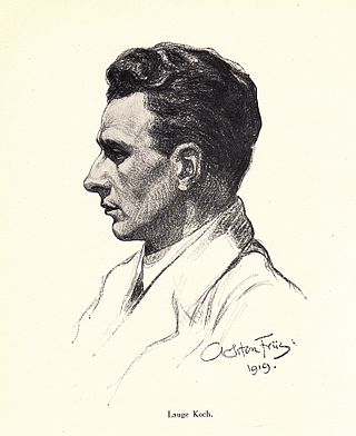
Lauge Koch was a Danish geologist and Arctic explorer.

Chauncy Dennison Harris was a pioneer of modern geography. His seminal works in the field of American urban geography along with his work on the Soviet Union during and after the Cold War era established him as one of the world's foremost urban geographers. He also made significant contributions to the geographical study of ethnicity, specifically with respect to non-Russian minorities living within the Soviet Union. Harris traveled regularly to the Soviet Union and played a key role in establishing a healthy dialog between Soviet and American scholars.
The British Cartographic Society (BCS) is an association of individuals and organisations dedicated to exploring and developing the world of maps. It is a registered charity. Membership includes national mapping agencies, publishers, designers, academics, researchers, map curators, individual cartographers, GIS specialists and ordinary members of the public with an interest in maps.
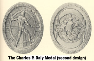
The Charles P. Daly Medal is awarded to individuals by the American Geographical Society (AGS) "for valuable or distinguished geographical services or labors." The medal was established in 1902. This medal was originally designed by Victor D. Brenner, but the destruction of the dies caused the medal to be redesigned in 1924 by Brenda Putnam.
Maitland Glacier is a glacier flowing along the west flank of the Hitchcock Heights into Mobiloil Inlet, on the east coast of the Antarctic Peninsula. This glacier may appear indistinctly in an aerial photograph taken by Sir Hubert Wilkins on his flight of December 20, 1928, but it was more clearly shown in aerial photographs taken by Lincoln Ellsworth in 1935 and by the United States Antarctic Service in 1940. It was named by the Advisory Committee on Antarctic Names in 1952 for Osborn Maitland Miller of the American Geographical Society, who by utilizing Wilkins' and Ellsworth's photographs assisted in constructing the first reconnaissance map of this area.

Alexey V. Postnikov is an internationally known specialist on the History of Science, with particular emphasis on the geography and cartography of Russia and these countries that have been under Russian influence from the 17th through the 20th centuries.
Richard Maitland Laws was Director of the British Antarctic Survey from 1973 to 1987; Master of St Edmund's College, Cambridge, from 1985 to 1996 and Secretary of the Zoological Society of London.
Osborn Maitland Miller (1897–1979) was a Scottish-American cartographer, surveyor and aerial photographer. A member of several expeditions himself, he also acted as adviser to other explorers. He developed several map projections, including the Bipolar Oblique Conic Conformal, the Miller Oblated Stereographic, and most notably the Miller Cylindrical in 1942.