Osen River

Last updated

Coordinates: 57°56′08.9″N36°22′00.8″E / 57.935806°N 36.366889°E / 57.935806; 36.366889

Geographic coordinate system Coordinate system

A geographic coordinate system is a coordinate system that enables every location on Earth to be specified by a set of numbers, letters or symbols. The coordinates are often chosen such that one of the numbers represents a vertical position and two or three of the numbers represent a horizontal position; alternatively, a geographic position may be expressed in a combined three-dimensional Cartesian vector. A common choice of coordinates is latitude, longitude and elevation. To specify a location on a plane requires a map projection.

Osen
Russian: Осень
Rybinsk vdhr.svg
Country Russia
Physical characteristics
River mouth Mologa
Length 8.7 km (5 mi) [1]
Basin features
Basin size 3,210 km2 (1,240 sq mi) [1]
Map of the Rybinsk Reservoir basin. The Osen is shown on the map as a stretch between the Melecha and the Mologa. Rybinsk vdhr eng.svg
Map of the Rybinsk Reservoir basin. The Osen is shown on the map as a stretch between the Melecha and the Mologa.

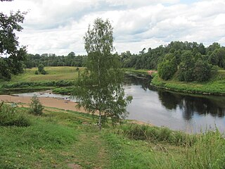
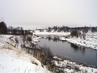
The Osen (Russian : Осень) is a river in Bezhetsky District of Tver Oblast in Russia. It is a major right tributary of the Mologa River. It is 8.7 kilometres (5.4 mi) long, and the area of its basin is 3,210 square kilometres (1,240 sq mi). [1]

Russian language East Slavic language

Russian is an East Slavic language, which is official in the Russian Federation, Belarus, Kazakhstan and Kyrgyzstan, as well as being widely used throughout Eastern Europe, the Baltic states, the Caucasus and Central Asia. It was the de facto language of the Soviet Union until its dissolution on 25 December 1991. Although nearly three decades have passed since the breakup of the Soviet Union, Russian is used in official capacity or in public life in all the post-Soviet nation-states, as well as in Israel and Mongolia.

Bezhetsky District District in Tver Oblast, Russia

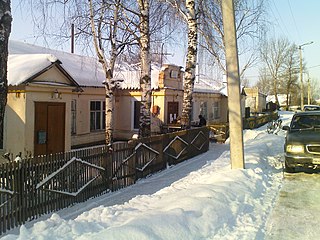
Bezhetsky District is an administrative and municipal district (raion), one of the thirty-six in Tver Oblast, Russia. It is located in the east of the oblast and borders with Molokovsky District in the north, Krasnokholmsky District in the northwest, Sonkovsky and Kesovogorsky Districts in the east, Kashinsky District in the southeast, Rameshkovsky District in the south, and with Maksatikhinsky District in the west. The area of the district is 2,810 square kilometers (1,080 sq mi). Its administrative center is the town of Bezhetsk. Population: 36,701 ; 14,277 (2002 Census); 18,786 (1989 Census). The population of Bezhetsk accounts for 66.8% of the district's total population.

Tver Oblast First-level administrative division of Russia

Tver Oblast is a federal subject of Russia. Its administrative center is the city of Tver. From 1935 to 1990, it was known as Kalinin Oblast, named after Mikhail Kalinin. Population: 1,353,392.

The source of the Osen is located in Tver Oblast, close to the village of Pereuz. The Osen is formed by two rivers, the Mogocha and the Melecha, both of which are about 100 kilometres (62 mi) long. The Osen flows southwest and joins the Mologa at the village of Yeski.

Mogocha River river in Tver Oblast, Russia

The Mogocha is a river in Krasnokholmsky, Molokovsky, and Bezhetsky Districts of Tver Oblast in Russia. Together with the Melecha River, it forms the Osen, a major right tributary of the Mologa River. It is 106 kilometres (66 mi) long, and the area of its basin is 1,880 square kilometres (730 sq mi). The principal tributaries of the Mogocha are the Uyvesh River (left) and the Loyka River (right).

Melecha River river in Tver Oblast, Russia

The Melecha is a river in Sandovsky, Molokovsky, and Bezhetsky Districts of Tver Oblast in Russia. Together with the Mogocha River, it forms the Osen, a major right tributary of the Mologa River. It is 95 kilometres (59 mi) long, and the area of its basin is 1,310 square kilometres (510 sq mi). The principal tributary is the Belaya River (left).

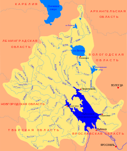
Despite the short length, the Osen has a rather big drainage area. It includes almost all of Molokovsky District, the southern half of Sandovsky District, the northern and the western parts of Bezhetsky District, and the southern half of Krasnokholmsky District, as well as minor areas in Vesyegonsky and Sonkovsky Districts. The town of Krasny Kholm and the urban-type settlement of Molokovo lie in the drainage basin of the Osen.

Molokovsky District District in Tver Oblast, Russia

Molokovsky District is an administrative and municipal district (raion), one of the thirty-six in Tver Oblast, Russia. It is located in the northeast of the oblast and borders with Sandovsky District in the north, Vesyegonsky District in the northeast, Krasnokholmsky District in the east, Bezhetsky District in the south, and with Maksatikhinsky District in the west. The area of the district is 1,182.6 square kilometers (456.6 sq mi). Its administrative center is the urban locality of Molokovo. Population: 5,235 ; 7,015 (2002 Census); 8,931 (1989 Census). The population of Molokovo accounts for 44.5% of the district's total population.

Sandovsky District District in Tver Oblast, Russia

Sandovsky District is an administrative and municipal district (raion), one of the thirty-six in Tver Oblast, Russia. It is located in the northeast of the oblast and borders with Ustyuzhensky District of Vologda Oblast in the north, Vesyegonsky District in the northeast, Molokovsky District in the southeast, Maksatikhinsky District in the south, Lesnoy District in the west, and with Pestovsky District of Novgorod Oblast in the northwest. The area of the district is 1,608 square kilometers (621 sq mi). Its administrative center is the urban locality of Sandovo. Population: 6,811 ; 9,385 (2002 Census); 12,495 (1989 Census). The population of Sandovo accounts for 51.5% of the district's total population.

Krasnokholmsky District District in Tver Oblast, Russia

Krasnokholmsky District is an administrative and municipal district (raion), one of the thirty-six in Tver Oblast, Russia. It is located in the northeast of the oblast and borders with Vesyegonsky District in the north, Breytovsky District of Yaroslavl Oblast in the northeast, Nekouzsky District, also of Yaroslavl Oblast, in the southeast, Sonkovsky District in the south, Bezhetsky District in the southwest, and with Molokovsky District in the northwest. The area of the district is 1,495 square kilometers (577 sq mi). Its administrative center is the town of Krasny Kholm. Population: 11,835 ; 14,736 (2002 Census); 18,813 (1989 Census). The population of Krasny Kholm accounts for 47.4% of the district's total population.

Related Research Articles

Mologa River river in Russia

The Mologa is a river in Maksatikhinsky, Bezhetsky, Lesnoy, and Sandovsky Districts of Tver Oblast, Pestovsky District in Novgorod Oblast, and Ustyuzhensky and Cherepovetsky Districts in Vologda Oblast Russia. It is a left tributary of the Volga River. The lower course of the Mologa has been turned into the Rybinsk Reservoir. It is 456 kilometres (283 mi) long, and the area of its basin 29,700 square kilometres (11,500 sq mi). The principal tributaries of the Mologa are the Osen (right), the Volchina (left), the Kobozha (left), the Chagodoshcha (left) and the Sit.

Tvertsa River river in Russia

The Tvertsa is a river in Vyshnevolotsky, Spirovsky, Torzhoksky, and Kalininsky Districts, as well as in the cities of Torzhok and Tver in Tver Oblast, Russia, a left tributary of the Volga River. It is 188 kilometres (117 mi) long, and the area of its basin 6,510 square kilometres (2,510 sq mi). The principal tributaries of the Tvertsa are the Tigma River (left), the Shchegrinka River (right), the Osuga River (right), the Logovyazh River (left), and the Kava River (left).

Nerl River (Volga) river in Russia

The Nerl River is a river in Pereslavsky District of Yaroslavl and Kalyazinsky District of Tver Oblast in Russia, a right tributary of the Volga River. The length of the river is 112 kilometres (70 mi). The area of its drainage basin is 3,270 square kilometres (1,260 sq mi). Its main tributary is the Kubr River (left).

Shosha River river in Russia

Shosha River is a river in Zubtsovsky, Staritsky, Kalininsky and in Konakovsky Districts of Tver Oblast and Lotoshinsky District of Moscow Oblast in Russia. It is a right tributary of the Volga River. The length of the Shosha River is 163 kilometres (101 mi). The area of its basin is 3,080 square kilometres (1,190 sq mi). The river flows into the Ivankovo Reservoir. The Shosha freezes up in November through early January and stays icebound until late March or early April.

Kunya River river in Kunyinsky, Velikoluksky, and Loknyansky Districts of Pskov Oblast, Toropetsky District of Tver Oblast, and Kholmsky District of Novgorod Oblast in Russia

The Kunya is a river in Kunyinsky, Velikoluksky, and Loknyansky Districts of Pskov Oblast, Toropetsky District of Tver Oblast, and Kholmsky District of Novgorod Oblast in Russia. It is a major right tributary of the Lovat River. It is 258 kilometres (160 mi) long, and the area of its basin 5,143 square kilometres (1,986 sq mi). The town of Kholm is located in the mouth of the Kunya. The principal tributaries of the Kunya are the Oka, the Serezha, the Maly Tuder, and the Bolshoy Tuder.

Kashinka River river in Russia

Kashinka is a river in Kesovogorsky and Kashinsky Districts of Tver Oblast, Russia, a left tributary of the Volga River. The length of the river is 128 kilometres (80 mi), and the area of its drainage basin is 661 square kilometres (255 sq mi). The town of Kashin and the urban-type settlement of Kesova Gora are located along the Kashinka.

Medveditsa River (Volga basin) river

Medveditsa is a river in Spirovsky, Likhoslavlsky, Rameshkovsky, Kashinsky, and Kimrsky Districts of Tver Oblast, Russia, a left tributary of the Volga River. The main tributaries are the Kushalka River (left), the Ivitsa River (right), the Drezna River (left), the Rudomosh River (left), and the Yakhroma River (right). The length of the Medveditsa is 259 kilometres (161 mi), and the area of its drainage basin is 5,570 square kilometres (2,150 sq mi).

The Obsha is a river in Sychyovsky District of Smolensk Oblast and Oleninsky, Belsky, and Zharkovsky Districts of Tver Oblasts, Russia. It is a left tributary of the Mezha. It is 153 kilometres (95 mi) long, and the area of its basin 2,080 square kilometres (800 sq mi). The town of Bely is located on the banks of the Obsha.

Vazuza River river in Russia

The Vazuza is a river in Novoduginsky and Sychyovsky districts of Smolensk Oblast and Zubtsovsky District of Tver Oblast, Russia, a right tributary of the Volga River. It is 162 kilometres (101 mi) long, and its drainage basin covers 7,120 square kilometres (2,750 sq mi). The lower part of the river has been transformed into Vazuza Reservoir. The towns of Sychyovka and Zubtsov are located on the banks the Vazuza. The main tributaries of the Vazuza are the Kasnya River, the Gzhat River, and the Osuga River (left).

Selizharovka River river in Russia

Selizharovka is a river in Ostashkovsky and Selizharovsky Districts of Tver Oblast, Russia, a left tributary of the Volga River. The length of the river is 36 kilometres (22 mi), and the area of its drainage basin is 2,950 square kilometres (1,140 sq mi). It is one of the uppermost substantial tributaries of the Volga. The settlement of Selizharovo is located near the river mouth.

Sit River river in Russia

The Sit' River (Сить) is a tributary of the Rybinsk Reservoir. The river flows for 159 kilometres (99 mi) through Sonkovsky District of Tver Oblast and Nekouzsky and Breytovsky Districts of Yaroslavl Oblasts of Russia before entering the Rybinsk Reservoir near the large village of Breitovo. Its average width varies from 40 to 50 metres. The river mouth is about 1,500 metres (4,900 ft) wide. The drainage basin occupies some 1,900 square kilometres (730 sq mi). The river is 159 kilometres (99 mi) long.

The Korozhechna is a river in Sonkovsky Kesovogorsky, and Kashinsky Districts of Tver Oblast and in Myshkinsky and Uglichsky District of Yaroslavl Oblast in Russia. It is a left tributary of the Volga River. It is 147 kilometres (91 mi) long, and the area of its basin 1,690 square kilometres (650 sq mi).

Volchina River river in Russia

The Volchina is a river in Vyshnevolotsky, Udomelsky, and Maksatikhinsky Districts of Tver Oblast in Russia. It is a left tributary of the Mologa River. It is 106 kilometres (66 mi) long, and the area of its basin 3,050 square kilometres (1,180 sq mi). The main tributaries are the Tifina River (left) and the Vorozhba River (right).

The Shlina is a river in Firovsky, Bologovsky, and Vyshnevolotsky Districts, as well as of the closed urban-type settlement of Ozyorny of Tver Oblast of Russia. It is a tributary of the Tsna River and belongs to the drainage basin of the Neva and the Baltic Sea. It is 102 kilometres (63 mi) long, and the area of its basin 2,300 square kilometres (890 sq mi). The principal tributaries of the Shlina are the Granichnaya River (right), the Shlinka River (left), and the Lonnitsa River (right). The Lonnitsa is technically an inflow of the Vyshny Volochyok Reservoir.

Tifina River river in Russia

The Tifina, also known as the Tikhvinka is a river in Bezhetsky, Rameshkovsky, Maksatikhinsky, Likhoslavlsky, and Spirovsky Districts of Tver Oblast in Russia. It is a right tributary of the Volchina River and belongs to the drainage basin of the Volga River. It is 128 kilometres (80 mi) long, and the area of its basin 1,180 square kilometres (460 sq mi). The principal tributary is the Sudomlya (left).

Osuga River (Vazuza) river in Russia

The Osuga River is a river in Oleninsky, Rzhevsky, and Zubtsovsky Districts of Tver Oblast and in Sychyovsky District of Smolensk Oblast of Russia, a left tributary of the Vazuza River in the basin of the Volga River. The Osuga is 100 kilometres (62 mi) long, and the area of its drainage basin is 1,290 square kilometres (500 sq mi).

References

  1. 1 2 3 "Река Осень" (in Russian). State Water Register of Russia. Retrieved 18 July 2013.