
Oelde is a town in the district of Warendorf, in North Rhine-Westphalia, Germany. It is located near Beckum.

Westphalia is a region of northwestern Germany and one of the three historic parts of the state of North Rhine-Westphalia. It has an area of 20,210 square kilometres (7,800 sq mi) and 7.9 million inhabitants.

North Rhine-Westphalia, commonly shortened to NRW, is a German state (Land) in Western Germany. With more than 17.9 million inhabitants, it is the most populous state of Germany. Covering an area of 34,084 square kilometres (13,160 sq mi), it is the fourth-largest German state by size. Apart from the city-states, it is also the most densely populated state in Germany.

Extertal is a municipality in the Lippe district of North Rhine-Westphalia, Germany, with c. 11,500 inhabitants (2013).
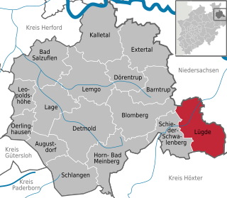
Lügde[ˈlʏçtʰə](listen) is a town in the Lippe district of North Rhine-Westphalia, Germany, with c. 9,800 inhabitants (2013).

Warendorf is a town in North Rhine-Westphalia, Germany, and capital of Warendorf District.

Telgte is a town in the Warendorf district, North Rhine-Westphalia, Germany. It is situated on the river Ems, 10 km east of Münster, and 15 km west of Warendorf.

Raesfeld is a municipality in the district of Borken in the state of North Rhine-Westphalia, Germany. It is located approximately 10 km south of Borken and 30 km east of the Dutch border.

Verl is a town in the district of Gütersloh in the state of North Rhine-Westphalia, Germany. It is approximately 15 km south of Bielefeld and 10 km east of Gütersloh.

Beverungen is a town in Höxter district in North Rhine-Westphalia, Germany.

Borchen is a municipality in the district of Paderborn, in North Rhine-Westphalia, Germany.

Lotte is a municipality in the district of Steinfurt, in North Rhine-Westphalia, Germany.
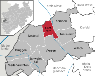
Grefrath is a municipality in the district of Viersen, in the western part of North Rhine-Westphalia, Germany.

Beckum is a town in the northern part of North Rhine-Westphalia, Germany. It is about 20 km north-east of Hamm and 35 km south-east of Münster. It gives its name to the nearby Beckum Hills.
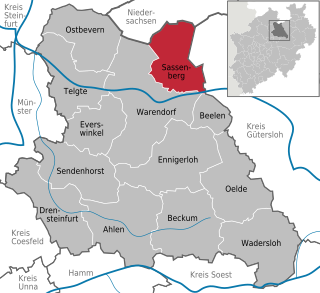
Sassenberg(German pronunciation: [ˈzasn̩bɛʁk]) is a town in the district of Warendorf, in North Rhine-Westphalia, Germany. It is situated approximately 6 km north-east of Warendorf and 30 km east of Münster.

Sendenhorst is a town in the district of Warendorf, in North Rhine-Westphalia, Germany. It is situated approximately 20 km (12 mi) north of Hamm and 20 km (12 mi) south-east of Münster.

Beelen is a municipality in the district of Warendorf, in North Rhine-Westphalia, Germany. It is situated approximately 30 km south-west of Bielefeld and 35 km east of Münster.
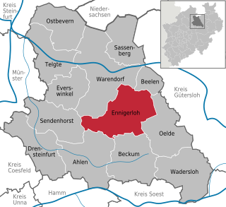
Ennigerloh is a town in the district of Warendorf, in North Rhine-Westphalia, Germany. It is situated approximately 25 km northeast of Hamm and 30 km southeast of Münster.

Everswinkel is a municipality in Warendorf District, North Rhine-Westphalia, Germany. It is situated some 30 km north of Hamm and 15 km east of Münster.
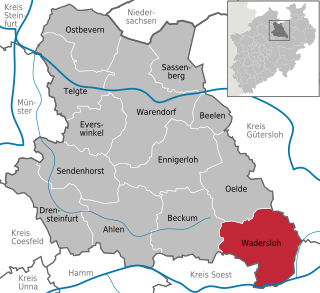
Wadersloh is a municipality in the district of Warendorf, in North Rhine-Westphalia, Germany. It is situated approximately 10 km north-west of Lippstadt and 30 km east of Hamm. In it there is a grammar school which is named Gymnasium Johanneum. Wadersloh was the place of a bike race in 2008 with competitors from all over the world.


