Industrial waste is the waste produced by industrial activity which includes any material that is rendered useless during a manufacturing process such as that of factories, mills, and mining operations. Types of industrial waste include dirt and gravel, masonry and concrete, scrap metal, oil, solvents, chemicals, scrap lumber, even vegetable matter from restaurants. Industrial waste may be solid, semi-solid or liquid in form. It may be hazardous waste or non-hazardous waste. Industrial waste may pollute the nearby soil or adjacent water bodies, and can contaminate groundwater, lakes, streams, rivers or coastal waters. Industrial waste is often mixed into municipal waste, making accurate assessments difficult. An estimate for the US goes as high as 7.6 billion tons of industrial waste produced annually, as of 2017. Most countries have enacted legislation to deal with the problem of industrial waste, but strictness and compliance regimes vary. Enforcement is always an issue.

Owerri is the capital city of Imo State in Nigeria, set in the heart of Igboland. It is also the state's largest city, followed by Orlu, Okigwe and Ohaji/Egbema. Owerri consists of three Local Government Areas including Owerri Municipal, Owerri North and Owerri West, it has an estimated population of 1,401,873 as of 2016 and is approximately 100 square kilometres (40 sq mi) in area. Owerri is bordered by the Otamiri River to the east and the Nworie River to the south. The Owerri Slogan is Heartland. It is also called the Las Vegas of Africa, due to the night life of the city and the numerous hotels, casino and leisure parks all over the city.

The Escravos River is a river in southern Nigeria, close to the city of Warri. "Escravos" is a Portuguese word meaning "slaves" and the area was one of the main conduits for slave trade between Nigeria and the United States in the 18th century. The Escravos is a distributary of the Niger River, it flows for 57 kilometres (35 mi), ending at the Bight of Benin of the Gulf of Guinea where it flows into the Atlantic Ocean. Chevron, a major US oil company, has its main Nigerian oil production facility at the mouth of the Escravos River. This oil terminal pumps approximately.

Rivers State, also known as Rivers, is a state in the Niger Delta region of southern Nigeria. Formed in 1967, when it was split from the former Eastern Region, Rivers State borders include Imo and Anambra to the north, Abia and Akwa Ibom to the east, and Bayelsa and Delta to the west.The State capital, Port Harcourt, is a metropolis that is considered to be the commercial center of the Nigerian oil industry.

The Kamchiya is a 191-kilometre (119 mi) river in eastern Bulgaria. From its longest source, Golyama Kamchiya, it has a total length of (244.5-kilometre. The river Kamchiya proper starts from the confluence of the two rivers springing from Eastern Stara Planina, Golyama Kamchiya and Luda Kamchiya, flows eastward to the Black Sea and empties into it 25 km south of Varna, in the Resort of Kamchiya.
Egbu is a town in Owerri North Local Government Area of Imo state in southern Nigeria, located on the Otamiri River near the city of Owerri. Egbu is among the brother clans in owerri known as "Ala Enyi" including; Ihitta Ogada, Awaka, Owerri Nchi Ise and Naze. Egbu is linked to other towns and villages by the Owerri–Umuahia road.
Nekede is a town in southeastern Nigeria. It is located near the city of Owerri. This is an Igbo speaking town that is made up of three distinct towns, viz Umualum, Umudibia, and Umuoma. Nekede also hosts the Imo State new Owerri capital territory popularly known as new Owerri. Federal University of Technology Owerri is 20 minutes drive from Nekede. It lies on the junction of the Nworie River and the Otamiri River. The population of Nekede is fast developing into a city with increasing population due to the citing of the Federal Polytechnic, Nekede, a federal government-owned higher institution.
Obinze is a community in southeastern Nigeria, located near the city of Owerri, Imo State under the supervision of Owerri West Local Government Area. The community Obinze had six clans/villages but a clan known as Umuanunu got their own autonomous community and separated. It's known for its fast rise in industrialization due to its location along Owerri-Port-harcourt Road, giving hosts/non-indigents access to the Local government area, State capital and neighbouring state such as Abia State, Anambra state and Rivers State. Obinze shares boundaries with Oforola, Avu, Ihiagwa, Eziobodo, Umuokani, Nekede and Mbirichi etc.
Imo State is a state in the South-East geopolitical zone of Nigeria, bordered to the north by Anambra State, Rivers State to the west and south, and Abia State to the east. It takes its name from the Imo River which flows along the state's eastern border. The state capital is Owerri and the State's slogan is the "Eastern Heartland."
Ihiagwa is a town in Owerri West Local Government Area of Imo State, Nigeria. It is located 12 km (7.5 mi) south of the capital city of Owerri. The township is composed of eight villages: Umuelem, Umuchima, Mboke, Nnkaramochie, Iriamogu, Aku/Umuokwo, Ibuzo and Umuezeawula. Ihiagwa has been divided into two autonomous communities, namely Ihiagwa Ancient Kingdom (Chimelem), comprising two villages: Umuelem and Umuchima;and Dindi-Ihiagwa, comprising the remaining six villages, all divisions done for administrative and developmental reasons. Each autonomous community is a monarchy ruled by an Eze.
Umuagwo is a town in the Ohaji/Egbema Local Government Area (LGA) of Imo State in Nigeria. The population is mostly Christian and Igbo-speaking. The town lies on the Otamiri River downstream from Ihiagwa and 26 km (16 mi) from Owerri on the Port Harcourt road. Eze Tony Oguzie, Chairman of the Council of Traditional Rulers in the Orlu senatorial zone, is monarch of Umuagwo.
Chokocho is a community in Etche Local Government Area in Rivers State, Nigeria near the Otamiri River. It has a population of about 18000 residents. The Chokocho bridge across the Otamiri, damaged during the Nigerian civil war, was rebuilt during the governorship of Peter Odili. The bridge on the Igwuruta – Okehi – Okpalla road is 60m x 11m, built by Setraco Nigeria Ltd and completed in December 2002. In March 2008, Ephraim Nwuzi of the Etche Local Government Area said he was going to complete "abandoned projects" like the cottage hospital at Chokocho.

Echie administratively known as Etche is an indigenous Igbo group mostly found in the Niger Delta region of Nigeria. Presently, its people makeup Etche and Omuma, two of the 23 Local Government Areas of Rivers State the can also been found in Ngor Okpala L.G.A and Omuma town both in Imo state. They are part of the 13 federal constituencies representing River State in Nigeria's National Assembly and part of the Rivers East Senatorial District. Its people are mostly farmers, and they speak the Etche dialect of the Igbo language family.
Owerri West is a Local Government Area of Imo State, Nigeria. Its headquarters are in the town of Umuguma. Owerri West Local Government is administered under the terms of the Constitution of the Federal Republic of Nigeria. Elections to the office of the Chairman of the local government are held through nominations by registered political parties as stipulated by the constitution of the Federal Republic of Nigeria, under the supervision of Imo State Electoral Commission. Owerri West was carved out of the former Owerri Local Government Area in 1996. A very large portion of the local government constitute the capital city of Imo State, Nigeria.

The Zadorra is a river tributary of the Ebro in the Basque Country at the north of the Iberian Peninsula. The river flows across province Álava all along till it pours into the Ebro near Miranda de Ebro in Burgos' lands. The river's water volume is the largest in Álava, with its basin being the most extensive in the province. Nowadays it provides by means of the Zadorra Reservoir System water supply for Vitoria and half of the Basque Autonomous Community.

The Imo River (Igbo:Imo) is located in southeastern Nigeria and flows 240 kilometres (150 mi) into the Atlantic Ocean. In Akwa Ibom State, the river is known as Imoh River, that is, Inyang Imoh, which translates to River of Wealth. Its estuary is around 40 kilometres (25 mi) wide, and the river has an annual discharge of 4 cubic kilometres (1.0 cu mi) with 26,000 hectares of wetland. The Imo's tributary rivers are the Otamiri and Oramirukwa. The Imo was cleared under the British colonial administration of Nigeria in 1907–1908 and 1911; first to Aba and then to Udo near Umuahia.
Savick Brook is a watercourse in Lancashire, England, which runs from the outskirts of Longridge westward north of Preston to the River Ribble.
Umuguma Town is Owerri West Local Government Area's headquarters. It is in Imo State, Nigeria. It evolved out of the old Owerri Local Government Area in 1996. Umuguma—a descendant of Arugo—is one of the 774 communities in the constitution of the Federal Republic of Nigeria as Local Government administrative

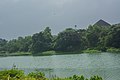
The Nworie River is a river in Nigeria that passes through Owerri and drains into the Otamiri River at Nekede. The length of the river from its source to its confluence is 9.2 km. The river is heavily polluted; in 2017 the local government issues warnings against using water from the river. In order to increase the state's supply of electricity, the formal President of Nigeria, Muhammadu Buhari approved the conceptual design of a proposed power producing facility near the Nworie River in Owerri, the capital of Imo.
Michigan Disposal Service, also known as Kalamazoo City Dump, Kalamazoo City Landfill, Dispose-O-Waste and the Cork Street Landfill, is a 68-acre Superfund site in Kalamazoo, Michigan. Davis Creek is adjacent to the site. It is one of six Superfund sites in the Kalamazoo River watershed.