
Berney Marshes and Breydon Water RSPB reserve is a nature reserve managed by the Royal Society for the Protection of Birds (RSPB). Berney Marshes is situated south of the River Bure while Breydon water is the combined estuary of the River Waveney and the River Yare inland from Great Yarmouth in Norfolk, England.

WWT Slimbridge is a wetland wildlife reserve near Slimbridge in Gloucestershire, England. It is midway between Bristol and Gloucester on the eastern side of the estuary of the River Severn. The reserve, set up by the artist and naturalist Sir Peter Scott, opened in November 1946. Scott subsequently founded the Wildfowl & Wetlands Trust, which has since opened nine other reserves around the country. Slimbridge comprises some 800 hectares of pasture, reed bed, lagoon and salt marsh. Many water birds live there all year round, and others are migrants on their ways to and from their summer breeding grounds. Other birds overwinter, including large numbers of white-fronted geese and increasing numbers of Bewick's swans.

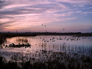
Snettisham RSPB reserve is a nature reserve in the care of the Royal Society for the Protection of Birds, situated near Snettisham in the county of Norfolk, England, north of King's Lynn, and close to Sandringham. It faces The Wash, a large estuary. In autumn and winter, the big tides of the Wash pushes up hundreds of thousands of wading birds onto the Norfolk coast. The nature reserve's bird lagoons provide a safe habitat for them.
Strumpshaw Fen is a nature reserve managed by the Royal Society for the Protection of Birds (RSPB). It is situated at Strumpshaw on the River Yare in the English county of Norfolk around 6 miles (9.7 km) east of Norwich. The Buckenham Marshes RSPB reserve borders the reserve to the east.

Titchwell Marsh is an English nature reserve owned and managed by the Royal Society for the Protection of Birds (RSPB). Located on the north coast of the county of Norfolk, between the villages of Titchwell and Thornham, about 8 km (5.0 mi) east of the seaside resort of Hunstanton, its 171 hectares include reed beds, saltmarshes, a freshwater lagoon and sandy beach, with a small woodland area near the car park. This internationally important reserve is part of the North Norfolk Coast Site of Special Scientific Interest (SSSI) and the Norfolk Coast Area of Outstanding Natural Beauty (AONB), and is also protected through Natura 2000, Special Protection Area (SPA) and Ramsar listings.

Ouse Washes is a linear 2,513.6-hectare (6,211-acre) biological Site of Special Scientific Interest stretching from near St Ives in Cambridgeshire to Downham Market in Norfolk, England. It is also a Ramsar internationally important wetland site, a Special Protection Area for birds, a Special Area of Conservation and a Nature Conservation Review site, Grade I. An area of 186 hectares between March and Ely is managed by the Wildlife Trust for Bedfordshire, Cambridgeshire and Northamptonshire and another area near Chatteris is managed by the Royal Society for the Protection of Birds. The Wildfowl & Wetlands Trust manages another area near Welney.

Sandwell Valley RSPB reserve is a nature reserve, run by the RSPB, in Sandwell Valley, to the north of West Bromwich, in the Sandwell borough of West Midlands in England. It is adjacent to, and shares its main lake with, Sandwell Valley Country Park and near the settlement of Hamstead.

Blacktoft Sands RSPB reserve is a nature reserve in the East Riding of Yorkshire, England. It is managed by the Royal Society for the Protection of Birds, which leases the site from Associated British Ports.

Insh Marshes are an area of floodplain of the River Spey between Kingussie and Kincraig in Badenoch and Strathspey, Highland, Scotland. The marshes are said to be one of the most important wetlands in Europe. They lie at altitude of approximately 240 to 220 m above sea level, and form one of the largest areas of floodplain mire and fen vegetation in Scotland.
Nene Washes is a 1,522-hectare (3,760-acre) biological Site of Special Scientific Interest on the bank of the River Nene east of Peterborough in Cambridgeshire, England. It is also a Ramsar internationally important wetland site, a Special Area of Conservation, a Special Protection Area and a Nature Conservation Review site. An area of 280 hectares is managed by the Royal Society for the Protection of Birds. The total area of the Ramsar site is 1,517 hectares.

RSPB Dearne Valley Old Moor is an 89-hectare (220-acre) wetlands nature reserve in the Dearne Valley near Barnsley, South Yorkshire, run by the Royal Society for the Protection of Birds (RSPB). It lies on the junction of the A633 and A6195 roads and is bordered by the Trans Pennine Trail long-distance path. Following the end of coal mining locally, the Dearne Valley had become a derelict post-industrial area, and the removal of soil to cover an adjacent polluted site enabled the creation of the wetlands at Old Moor.

Otmoor or Ot Moor is an area of wetland and wet grassland in Oxfordshire, England, located halfway between Oxford and Bicester. It is about 60 metres (200 ft) above sea level, and has an area of nearly 400 hectares.

Burton Mere Wetlands is a nature reserve on the Dee Estuary straddling the border between Cheshire, England and Flintshire, Wales. It is run by the Royal Society for the Protection of Birds (RSPB) and incorporates the older Inner Marsh Farm reserve. It lies near the village of Burton, about 3 kilometres (1.9 mi) south of Neston. It has all been developed by the RSPB and includes a large area of mixed wetland habitats, bluebell woodlands, and arable fields all managed to attract wildlife.

Lodmoor is a Site of Special Scientific Interest (SSSI), RSPB reserve and country park in Dorset, England. The country park features a visitor centre, model railway and pitch and putt golf course. The SSSI has a wetland habitat with native birds that are rare in the UK and a range of migratory species.

Ynys-hir RSPB reserve is a nature reserve of the RSPB situated beside the Dyfi estuary in Ceredigion, mid Wales between Aberystwyth and Machynlleth. The reserve covers 550 hectares and includes a variety of habitats extending inland from mudflats and salt marsh through farmland and pools to oak woodland and hillside scrub. Facilities include a small visitor centre and seven hides.

Conwy RSPB reserve is a nature reserve of the Royal Society for the Protection of Birds situated on the east side of the Conwy estuary in Conwy county borough, North Wales. It covers 47 hectares and protects a variety of habitats including grassland, scrubland, reedbeds, salt marsh and mudflats. It was created as compensation for the destruction of areas of wildlife habitat during the construction of the A55 road tunnel under the estuary between 1986 and 1991. Waste from dredging was dumped onto the site which was later landscaped to create two large pools and several smaller ones. The reserve opened to the public on 14 April 1995 and facilities for visitors now include a visitor centre, café and three hides. A farmers' market is held on the reserve car park each month.

Ashleworth Ham is a 104.73-hectare (258.8-acre) biological Site of Special Scientific Interest. It is a large area of grassland on the Severn floodplain, north of Ashleworth in Gloucestershire, England. It is registered as a Site of Special Scientific Interest and was notified in 1974 and renotified in 1985. Ashleworth Ham received this designation because it is one of three sites in the Severn Vale where migratory waterfowl winter.

West Thorney is a village and civil parish in the Chichester district in West Sussex, England located nine kilometres west of Chichester south of the A27 road.

Ham Wall is an English wetland National Nature Reserve (NNR) 4 kilometres (2.5 mi) west of Glastonbury on the Somerset Levels. It is managed by the Royal Society for the Protection of Birds (RSPB). Since the last Ice Age, decomposing plants in the marshes of the Brue valley in Somerset have accumulated as deep layers of peat that were commercially exploited on a large scale in the twentieth century. Consumer demand eventually declined, and in 1994 the landowners, Fisons, gave their old workings to what is now Natural England, who passed the management of the 260 hectares Ham Wall section to the RSPB.
Otmoor SSSI is a 213-hectare (530-acre) biological Site of Special Scientific Interest north of Oxford in Oxfordshire. It is adjacent to RSPB Otmoor, and they are both part of Otmoor, an area of wetland and wet grassland which was enclosed in the early nineteenth century.

