Oued Seguen | |
|---|---|
Commune and town | |
 | |
| Country | |
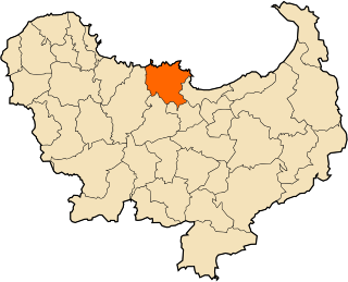
| Province | Mila Province |
| Population (1998) | |
• Total | 11,792 |
| Time zone | UTC+1 (CET) |
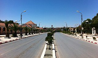
Oued Seguen is a town and commune in Mila Province, Algeria. At the 1998 census it had a population of 11,792. [1] .
Oued Seguen | |
|---|---|
Commune and town | |
| | |
| Country | |
| Province | Mila Province |
| Population (1998) | |
• Total | 11,792 |
| Time zone | UTC+1 (CET) |
Oued Seguen is a town and commune in Mila Province, Algeria. At the 1998 census it had a population of 11,792. [1] .
Bordj Bou Arréridj is the capital city of Bordj Bou Arréridj Province, Algeria. According to the 2008 estimation, its population was 168,346. It is situated 148 miles by road east of Algiers, near the Hodna Massif in the southern Kabylie Mountains, at an elevation of 916 metres.
The Algerian Air Force is the aerial arm of the Algerian People's National Army.

Dar El Beïda is a suburb of Algiers, Algeria. It is the seat of the district with the same name. During French colonial times, it was officially called by its French name Maison Blanche, which meant the same thing as its current Arabic name: (the) white house.. It is pronounced in Classical Arabic and in Darja. It has an area of 3200 hectares. It is home to the international Houari Boumedienne Airport, the largest in Algeria. The airport is divided into two main terminals, one for international flights and the other one for domestic flights. It has 44,753 inhabitants as of the 1998 census. In 1987 it had 12,900 inhabitants.
Ben Allal, Algeria is a town in northern Algeria.
Souk El Khemis is a town and commune in Bouïra Province, Algeria. According to the 1998 census it had a population of 8,039. The town is located at 36° 23' 17" N, 3° 38' 6" E and the name means Thursday Market.
Grarem Gouga is a town in Grarem municipality, Grarem Gouga District, Mila Province, Algeria.
Hamala, Algeria is a town and commune in Mila Province, Algeria. At the 1998 census it had a population of 10810.
Rouached is a town and commune in Mila Province, Algeria. At the 1998 census it had a population of 25399.
Teleghma is a town and commune in Mila Province, Algeria. At the 2008 census it had a population of 48,846.
Abed Hamdani Stadium is a multi-use stadium in El Khroub, Algeria. It is currently used mostly for football matches and is the home ground of Algerian Ligue Professionnelle 2 side AS Khroub. The stadium has an official capacity of 10,000 people.

Aïn Bouziane is a town and commune in Skikda Province in north-eastern Algeria.

Aïn Kechra is a town and commune in Skikda Province in north-eastern Algeria.
Aïn Zouit is a town and commune in Skikda Province in north-eastern Algeria.
Beni Oulbane is a town and commune in Skikda Province in north-eastern Algeria.
Beni Zid is a town and commune in Skikda Province in north-eastern Algeria.

Bir El Ouiden is a town and commune in Skikda Province in north-eastern Algeria. In April 2008 it had a census population of 21,629 inhabitants.
Kerkera is a town and commune in Skikda Province in north-eastern Algeria.
Salah Bouchaour is a town and commune in Skikda Province in north-eastern Algeria.
Sidi Mezghiche is a town and commune in Skikda Province in north-eastern Algeria.

The Université Constantine 1, formerly Mentouri University of Constantine, is a university located in Constantine, Algeria. Designed by Brazilian architect Oscar Niemeyer, the university was built from 1969 to 1972.
36°10′16″N6°25′12″E / 36.170991°N 6.419985°E
| | This article about a location in Mila Province is a stub. You can help Wikipedia by expanding it. |
