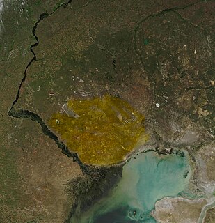
The Ryn Desert or Ryn-Peski Desert is a desert in western Kazakhstan, located north of the Caspian Sea and southeast of the Volga Upland. The borders of the desert are very loosely defined. Some maps show the desert almost entirely within the Caspian Depression, stretching almost to the coast of the Caspian Sea, while others show it north of the depression. It lies west of the Ural River between 46° N and 49° N latitude, and 48° E to 52° E longitude. Temperatures can reach extreme highs of 45 to 48 °C during summer and in winter they can drop to a low of −28 to −36 °C.
Łomna is a former village in the administrative district of Gmina Bircza, within Przemyśl County, Subcarpathian Voivodeship, in south-eastern Poland. It lies approximately 8 kilometres (5 mi) south of Bircza, 25 km (16 mi) south-west of Przemyśl, and 58 km (36 mi) south-east of the regional capital Rzeszów.

Shadaw Township is a township of Loikaw District in the eastern part of Kayah State in Myanmar.
Wójcin is a village in the administrative district of Gmina Piotrków Kujawski, within Radziejów County, Kuyavian-Pomeranian Voivodeship, in north-central Poland. It lies approximately 4 kilometres (2 mi) south of Piotrków Kujawski, 13 km (8 mi) south of Radziejów, and 58 km (36 mi) south of Toruń.

Wojnówka is a village in the administrative district of Gmina Dubicze Cerkiewne, within Hajnówka County, Podlaskie Voivodeship, in north-eastern Poland, close to the border with Belarus. It lies approximately 8 kilometres (5 mi) south-east of Dubicze Cerkiewne, 16 km (10 mi) south of Hajnówka, and 62 km (39 mi) south of the regional capital Białystok.
Wygoda is a village in the administrative district of Gmina Wola Krzysztoporska, within Piotrków County, Łódź Voivodeship, in central Poland. It lies approximately 2 kilometres (1 mi) south-east of Wola Krzysztoporska, 10 km (6 mi) south-west of Piotrków Trybunalski, and 51 km (32 mi) south of the regional capital Łódź.
Chrząstowice is a village in the administrative district of Gmina Wolbrom, within Olkusz County, Lesser Poland Voivodeship, in southern Poland. It lies approximately 10 kilometres (6 mi) south-west of Wolbrom, 10 km (6 mi) north-east of Olkusz, and 36 km (22 mi) north-west of the regional capital Kraków.
Grąbczewo is a village in the administrative district of Gmina Naruszewo, within Płońsk County, Masovian Voivodeship, in east-central Poland. It lies approximately 3 kilometres (2 mi) south-west of Naruszewo, 14 km (9 mi) south of Płońsk, and 57 km (35 mi) north-west of Warsaw.
Mącice is a village in the administrative district of Gmina Chorzele, within Przasnysz County, Masovian Voivodeship, in east-central Poland. It lies approximately 11 kilometres (7 mi) north-east of Chorzele, 36 km (22 mi) north of Przasnysz, and 124 km (77 mi) north of Warsaw.
Myszki is a village in the administrative district of Gmina Kiszkowo, within Gniezno County, Greater Poland Voivodeship, in west-central Poland. It lies approximately 6 kilometres (4 mi) east of Kiszkowo, 20 km (12 mi) west of Gniezno, and 36 km (22 mi) north-east of the regional capital Poznań.
Młynik is a village in the administrative district of Gmina Sośnie, within Ostrów Wielkopolski County, Greater Poland Voivodeship, in west-central Poland. It lies approximately 6 kilometres (4 mi) north of Sośnie, 17 km (11 mi) south-west of Ostrów Wielkopolski, and 109 km (68 mi) south-east of the regional capital Poznań.
Jastrowo is a village in the administrative district of Gmina Szamotuły, within Szamotuły County, Greater Poland Voivodeship, in west-central Poland. It lies approximately 5 kilometres (3 mi) west of Szamotuły and 36 km (22 mi) north-west of the regional capital Poznań.
Nowy Dworek is a village in the administrative district of Gmina Świebodzin, within Świebodzin County, Lubusz Voivodeship, in western Poland. It lies approximately 10 kilometres (6 mi) north of Świebodzin, 44 km (27 mi) north of Zielona Góra, and 48 km (30 mi) south of Gorzów Wielkopolski.
Siodłary is a village in the administrative district of Gmina Kamiennik, within Nysa County, Opole Voivodeship, in south-western Poland. It lies approximately 6 kilometres (4 mi) south of Kamiennik, 14 km (9 mi) west of Nysa, and 58 km (36 mi) west of the regional capital Opole.
Ruska Wieś is a village in the administrative district of Gmina Mrągowo, within Mrągowo County, Warmian-Masurian Voivodeship, in northern Poland. It lies approximately 10 kilometres (6 mi) north of Mrągowo and 58 km (36 mi) east of the regional capital Olsztyn.
Turośl is a village in the administrative district of Gmina Pisz, within Pisz County, Warmian-Masurian Voivodeship, in northern Poland. It lies approximately 18 kilometres (11 mi) south-west of Pisz and 79 km (49 mi) east of the regional capital Olsztyn.
Czarne Małe is a village in the administrative district of Gmina Czaplinek, within Drawsko County, West Pomeranian Voivodeship, in north-western Poland. It lies approximately 7 kilometres (4 mi) east of Czaplinek, 36 km (22 mi) east of Drawsko Pomorskie, and 117 km (73 mi) east of the regional capital Szczecin.
Mołdawinek is a settlement in the administrative district of Gmina Radowo Małe, within Łobez County, West Pomeranian Voivodeship, in north-western Poland. It lies approximately 9 kilometres (6 mi) north-west of Radowo Małe, 20 km (12 mi) west of Łobez, and 58 km (36 mi) north-east of the regional capital Szczecin.

Primavera do Leste is a municipality in the state of Mato Grosso in the Central-West Region of Brazil.

The Battle of Fraga was a battle of the Spanish Reconquista that took place on 17 July 1134 at Fraga, Aragon, Spain. The battle was fought between the forces of the Kingdom of Aragon, commanded by Alfonso the Battler and a variety of Almoravid forces that had come to the aid of the town of Fraga which was being besieged by King Alfonso I. The battle resulted in an Almoravid victory. The Aragonese monarch Alfonso I died shortly after the battle.
