Cambridgeshire is a county in the East of England, bordering Lincolnshire to the north, Norfolk to the north-east, Suffolk to the east, Essex and Hertfordshire to the south, and Bedfordshire and Northamptonshire to the west. The city of Cambridge is the county town. Following the Local Government Act 1972 restructuring, modern Cambridgeshire was formed in 1974 through the amalgamation of two administrative counties: Cambridgeshire and Isle of Ely, comprising the historic county of Cambridgeshire ; and Huntingdon and Peterborough, comprising the historic county of Huntingdonshire and the Soke of Peterborough, historically part of Northamptonshire. Cambridgeshire contains most of the region known as Silicon Fen.

The Wash is a rectangular bay and multiple estuary at the north-west corner of East Anglia on the East coast of England, where Norfolk meets Lincolnshire and both border the North Sea. One of Britain's broadest estuaries, it is fed by the rivers Witham, Welland, Nene and Great Ouse. It is a 62,046-hectare (153,320-acre) biological Site of Special Scientific Interest. It is also a Nature Conservation Review site, Grade I, a National Nature Reserve, a Ramsar site, a Special Area of Conservation and a Special Protection Area. It is in the Norfolk Coast Area of Outstanding Natural Beauty and part of it is the Snettisham Royal Society for the Protection of Birds nature reserve.

The River Great Ouse is a river in England, the longest of several British rivers called "Ouse". From Syresham in Northamptonshire, the Great Ouse flows through Buckinghamshire, Bedfordshire, Cambridgeshire and Norfolk to drain into the Wash and the North Sea near Kings Lynn. With a course of about 143 miles (230 km), mostly flowing north and east, it is the fifth longest river in the United Kingdom. The Great Ouse has been historically important for commercial navigation, and for draining the low-lying region through which it flows; its best-known tributary is the Cam, which runs through Cambridge. Its lower course passes through drained wetlands and fens and has been extensively modified, or channelised, to relieve flooding and provide a better route for barge traffic. The unmodified river would have changed course regularly after floods.
The River Little Ouse is a river in the east of England, a tributary of the River Great Ouse. For much of its length it defines the boundary between Norfolk and Suffolk.

The Fens, also known as the Fenlands, is a coastal plain in eastern England and the East Midlands. This naturally marshy region supports a rich ecology and numerous species, and helps absorb storms. Most of the fens were drained centuries ago, resulting in a flat, dry, low-lying agricultural region supported by a system of drainage channels and man-made rivers and automated pumping stations. There have been unintended consequences to this reclamation, as the land level has continued to sink and the dykes have been built higher to protect it from flooding.

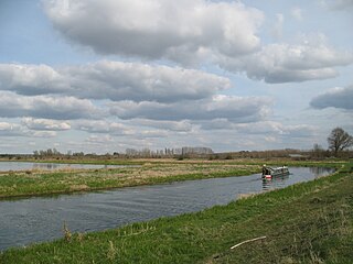
The Old Bedford River is an artificial, partial diversion of the waters of the River Great Ouse in the Fens of Cambridgeshire, England. It was named after the fourth Earl of Bedford who contracted with the local Commission of Sewers to drain the Great Level of the Fens beginning in 1630. It provided a steeper and shorter path for the waters of the Great Ouse, and was embanked to prevent them flooding the low ground of the South Fens. Throughout the project, the Earl and his Adventurers faced disruption from those who were opposed to drainage schemes. The project was deemed to have succeeded in draining the fens in 1637, but that decision was reversed in 1638. After a lull during the English Civil War, when much of the work was damaged, the Dutch engineer Cornelius Vermuyden worked with William Russell, the fifth Earl of Bedford to complete the drainage. Disruption and unrest continued while the work was carried out, resulting in the Adventurers employing armed guards. A second river, the New Bedford River, was cut parallel to the first channel, which then became the Old Bedford River. At some point, the Old Bedford River was split into two parts, when the upper section was diverted into the River Delph at Welches Dam, and the lower section was joined to the Counter Drain. Both parts retain the name, but are not connected to each other. The area between the two Bedford rivers acts as a large washland, which holds floodwater when the river channels cannot cope with the volume of water in them.

Ouse Washes is a linear 2,513.6 hectare biological Site of Special Scientific Interest stretching from near St Ives in Cambridgeshire to Downham Market in Norfolk. It is also a Ramsar internationally important wetland site, a Special Protection Area under the European Union Birds Directive, a Special Area of Conservation, and a Nature Conservation Review site, Grade I. An area of 186 hectares between March and Ely is managed by the Wildlife Trust for Bedfordshire, Cambridgeshire and Northamptonshire, and another area near Chatteris is managed by the Royal Society for the Protection of Birds. The Wildfowl & Wetlands Trust manages another area near Welney.

Welney is a village and civil parish in the Fens of England, and the county of Norfolk. The village is about 10 miles (16 km) south-west of the town of Downham Market, 20 miles (30 km) south of the town of King's Lynn and 45 miles (70 km) west of the city of Norwich. The county boundary with Cambridgeshire is adjacent, with the city of Cambridge 25 miles (40 km) to the south.

Sir Cornelius Vermuyden was a Dutch engineer who introduced Dutch land reclamation methods to England. Commissioned by the Crown to drain Hatfield Chase in the Isle of Axholme, Lincolnshire, Vermuyden was knighted in 1629 for his work and became an English citizen in 1633. In the 1650s, he directed major projects to drain The Fens of East Anglia, introducing the innovation of constructing washes, to allow periodic flooding of the area by excess waters.

Sutton or Sutton-in-the-Isle is village and civil parish in the county of Cambridgeshire in England, near the city of Ely. The "in-the-Isle" suffix refers to the fact that the village is part of the Isle of Ely, once an island in the Fens and also an administrative county until 1965.

RSPB Dearne Valley Old Moor is an 89-hectare (220-acre) wetlands nature reserve in the Dearne Valley near Barnsley, South Yorkshire, run by the Royal Society for the Protection of Birds (RSPB). It lies on the junction of the A633 and A6195 roads and is bordered by the Trans Pennine Trail long-distance path. Following the end of coal mining locally, the Dearne Valley had become a derelict post-industrial area, and the removal of soil to cover an adjacent polluted site enabled the creation of the wetlands at Old Moor.
Manea is a village and civil parish in the District of Fenland, Isle of Ely, Cambridgeshire, England.

Fen Drayton is a small village between Cambridge and St. Ives in Cambridgeshire, England, and between the villages of Fenstanton and Swavesey.

The Fens Waterways Link is a project to improve recreational boating opportunities in the counties of Cambridgeshire and Lincolnshire, England. By a combination of improvements to existing waterways and the construction of new links a circular route between Lincoln, Peterborough, Ely and Boston is planned. The project is being organised by the Environment Agency and financed from the Regional Development Agency and the European Union.
The Little Ouse Headwaters Project (LOHP) was set up in 2002 by local residents to promote conservation and enjoyment of the fenland habitats bordering the upper reaches of the River Little Ouse, which lies on the Norfolk-Suffolk border. The site lies between Blo' Norton in Norfolk and Thelnetham in Suffolk. It includes a number of areas including Hinderclay Fen, Blo' Norton Fen, Betty's Fen, The Frith, Blo' Norton Lowes, Blo' Norton Little Fen and Parker's Piece. The area also include parts of the Blo' Norton and Thelnetham Fen Site of Special Scientific Interest (SSSI).
The East Anglian Waterways Association is a waterway society and an umbrella organisation in East Anglia, England, UK.
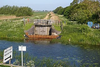
Welches Dam is a former civil parish in Cambridgeshire around 5 miles (8 km) to the north west of Ely. It covered an area of 2,355 acres (953 ha). Within the parish boundaries were the hamlet of the same name and the settlement of Purls Bridge. Welches Dam is the site of the visitor centre for the RSPB Ouse Washes reserve.
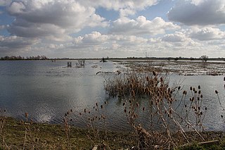
Washland or washes are areas of land adjacent to rivers which are deliberately flooded at times when the rivers are high, to avoid flooding in residential or important agricultural areas. They often provide for overwintering wildfowl, and several include important nature reserves.

Prickwillow Museum, formerly known as the Prickwillow Drainage Engine Museum, tells the story of the changing face of the Fens and its network of drainage systems and pumping stations. The museum is housed in the old pumping station in Prickwillow, 4 miles (6.4 km) east of the city of Ely in Cambridgeshire, England.
The Bedford Level Corporation was founded in England in 1663 to manage the draining of the Fens of East Central England. It formalised the legal status of the Company of Adventurers previously formed by the Duke of Bedford to reclaim 95,000 acres of the Bedford Level.
