Pensacola International Airport, formerly Pensacola Gulf Coast Regional Airport and Pensacola Regional Airport, is a public use airport three nautical miles northeast of the central business district of Pensacola, in Escambia County, Florida, United States. It is owned by the City of Pensacola. Despite its name, the airport does not offer scheduled international flights, though chartered international flights are not uncommon. This airport is one of the five major airports in North Florida, and among these is the second largest by passenger count, only behind Jacksonville. The other airports in the North Florida region are: Northwest Florida Beaches International Airport, Destin-Fort Walton Beach Airport, Tallahassee International Airport, and Jacksonville International Airport.

Tallahassee International Airport is a city-owned airport five miles southwest of downtown Tallahassee, in Leon County, Florida, United States. It serves the state capital of Florida, and its surrounding areas; it is one of the major airports in north Florida, the others being Pensacola International Airport, Northwest Florida Beaches International Airport, and Jacksonville International Airport. Despite its name, it does not yet service any international destinations.

Greater Binghamton Airport is a county-owned American airport eight miles north of Binghamton, in Broome County, New York. It is in East Maine, New York and serves the Southern Tier of New York.
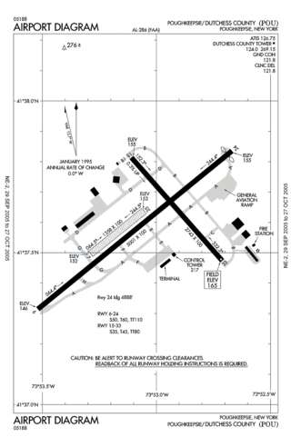
Hudson Valley Regional Airport, formerly known as Dutchess County Airport, is a county-owned public-use airport located on State Route 376 in the Town of Wappinger, Dutchess County, New York, United States, four miles (6 km) south of the central business district of Poughkeepsie. It is sometimes called Poughkeepsie Airport, which gives it the code POU. The airport provides corporate and general aviation transportation services.

Rogue Valley International–Medford Airport is a public-use airport three miles north of downtown Medford, in Jackson County, Oregon, United States. Owned and operated by Jackson County's Aviation Authority, the airport serves southwest Oregon. Originally named Medford–Jackson County Airport, it was renamed to Rogue Valley International–Medford Airport after it became an international airport in 1994.

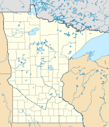
Range Regional Airport is a public use airport located four nautical miles southeast of the central business district of Hibbing, in Saint Louis County, Minnesota, United States. It was formerly known as Chisholm-Hibbing Airport or Chisholm-Hibbing Municipal Airport. The airport is mostly used for general aviation but is also served by one commercial and one charter airline. Scheduled passenger service is subsidized by the Essential Air Service program.

Montgomery Regional Airport is a civil-military airport seven miles southwest of Montgomery, the capital of Alabama. Owned by the Montgomery Airport Authority, it is used for general aviation and military aviation, and sees two airlines.

Arnold Palmer Regional Airport is in Westmoreland County, Pennsylvania, United States, two miles (3 km) southwest of Latrobe and about 33 miles (53 km) southeast of Pittsburgh. It was formerly Westmoreland County Airport; it was renamed in September 1999 for Arnold Palmer as part of his 70th birthday celebration. Palmer learned to fly at the airport, and the dedication ceremony included Governor Tom Ridge and a flyover of three A-10s of the Pennsylvania Air National Guard.
East Texas Regional Airport is an airport located in Gregg County, Texas. The airport is just South of the city of Lakeport, and is 9 mi south of Longview. Its IATA identifier GGG comes from its prior name, Gregg County Airport. The airport is used for general aviation and military training; it has scheduled flights to Dallas/Fort Worth on American Airlines/American Eagle.
Akron Fulton Intl Airport is in Akron, Summit County, Ohio, United States. It is owned by the City of Akron; FAA's National Plan of Integrated Airport Systems for 2011–2015 called it a general aviation airport.

Tom Madsen Airport is a state-owned public-use airport in City of Unalaska, on Amaknak Island in the Aleutian Islands, off the coast of the U.S. state of Alaska. It is located near the Bering Sea coast of Unalaska Island, 800 miles (1,300 km) southwest of Anchorage and 1,950 miles (3,140 km) from Seattle.

Renton Municipal Airport is a public use airport located in Renton, a city in King County, Washington, United States. The airport was renamed Clayton Scott Field in 2005 to celebrate the 100th birthday of Clayton Scott. The airport's northern boundary is Lake Washington and the Will Rogers–Wiley Post Memorial Seaplane Base. Renton Airport has a floating dock and a launching ramp for conversion from wheeled landings to water takeoffs and landings.

Concord-Padgett Regional Airport is a city-owned, public-use airport located seven nautical miles (13 km) west of the central business district of Concord, a city in Cabarrus County, North Carolina, United States. According to the FAA's National Plan of Integrated Airport Systems for 2009–2013, it is classified as a reliever airport for Charlotte Douglas International Airport.
Northwest Missouri Regional Airport is a city-owned public use airport located two nautical miles (3.7 km) west of the central business district of Maryville, a city in Nodaway County, Missouri, United States. The airport is used for general aviation with no commercial airlines.

Treasure Coast International Airport is a public airport located three miles (5 km) northwest of the central business district of Fort Pierce, a city in St. Lucie County, Florida, United States. It is owned by the St. Lucie Board of County Commissioners.
Chester County G. O. Carlson Airport is a public airport two miles (3 km) west of Coatesville, in Valley Township, Chester County, Pennsylvania. It is owned by the Chester County Area Airport Authority.
Red Wing Regional Airport is a city-owned public-use airport located in Pierce County, Wisconsin, three nautical miles (6 km) northeast of the central business district of Red Wing, a city in Goodhue County, Minnesota, United States.
Northeast Ohio Regional Airport, owned and operated by the Ashtabula County Airport Authority, is a public-use airport in Ashtabula County, Ohio, United States, eight nautical miles (15 km) southeast of the central business district of the city of Ashtabula. Airport is located in Denmark Township near the Village of Jefferson, which is the County Seat of Ashtabula County. Located within minutes of Lake Erie and the intersection of major Interstates 90 (East/West) and 11 (North/South), the convenient location of the Northeast Ohio Regional Airport (HZY) makes it the perfect choice for both corporate and private travelers. The airport is located in the village of Jefferson, about 10 miles (16 km) south of Lake Erie. According to the FAA's National Plan of Integrated Airport Systems for 2009–2013, it is classified as a general aviation airport.

St. George Regional Airport is a city-owned airport in St. George, Washington County, Utah.

East Coast Jets Flight 81 was a business jet flight operated by East Coast Jets that crashed on July 31, 2008 while attempting a go-around at Owatonna Degner Regional Airport near Owatonna, Minnesota, killing all eight passengers and crew on board. The flight originated in Atlantic City International Airport, and was scheduled to land in Owatonna. The crew made a go-around attempt after the aircraft touched down, but it overran the runway, hit Approach Lighting System fixtures, stalled and crashed, with the main wreckage coming to rest 2,400 ft (730 m) from the runway end.