
The Eurasian plate is a tectonic plate that includes most of Eurasia, with the notable exceptions of the Arabian Peninsula, the Indian subcontinent, and the area east of the Chersky Range in eastern Siberia. It also includes oceanic crust extending westward to the Mid-Atlantic Ridge and northward to the Gakkel Ridge.
The Indo-Australian plate is or was a major tectonic plate. It is in the process of separation into three plates, and may be currently separated into more than one plate. It contains the continent of Australia, its surrounding ocean and extends north-west to include the Indian subcontinent and the adjacent waters.

The Australian plate is a major tectonic plate in the eastern and, largely, southern hemispheres. Originally a part of the ancient continent of Gondwana, Australia remained connected to India and Antarctica until approximately 100 million years ago when India broke away and began moving north. Australia and Antarctica had begun rifting by 96 million years ago and completely separated a while after this, some believing as recently as 45 million years ago, but most accepting presently that this had occurred by 60 million years ago.
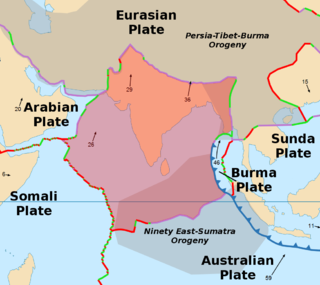
The Indian plate is a minor tectonic plate straddling the equator in the Eastern Hemisphere. Originally a part of the ancient continent of Gondwana, the Indian plate broke away from the other fragments of Gondwana 100 million years ago and began moving north, carrying Insular India with it. It was once fused with the adjacent Australian plate to form a single Indo-Australian plate; recent studies suggest that India and Australia have been separate plates for at least 3 million years. The Indian plate includes most of modern South Asia and a portion of the basin under the Indian Ocean, including parts of South China, western Indonesia, and extending up to but not including Ladakh, Kohistan, and Balochistan in Pakistan.
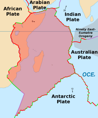
The Somali plate is a minor tectonic plate which straddles the Equator in the Eastern Hemisphere. It is currently in the process of separating from the African plate along the East African Rift Valley. It is approximately centered on the island of Madagascar and includes about half of the east coast of Africa, from the Gulf of Aden in the north through the East African Rift Valley. The southern boundary with the Nubian–African plate is a diffuse plate boundary consisting of the Lwandle plate.

A mid-ocean ridge (MOR) is a seafloor mountain system formed by plate tectonics. It typically has a depth of about 2,600 meters (8,500 ft) and rises about 2,000 meters (6,600 ft) above the deepest portion of an ocean basin. This feature is where seafloor spreading takes place along a divergent plate boundary. The rate of seafloor spreading determines the morphology of the crest of the mid-ocean ridge and its width in an ocean basin.
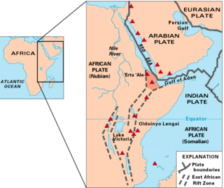
The East African Rift (EAR) or East African Rift System (EARS) is an active continental rift zone in East Africa. The EAR began developing around the onset of the Miocene, 22–25 million years ago. It was formerly considered to be part of a larger Great Rift Valley that extended north to Asia Minor.

The Carlsberg Ridge is the northern section of the Central Indian Ridge, a divergent tectonic plate boundary between the African plate and the Indo-Australian plate, traversing the western regions of the Indian Ocean.
The Afar Triple Junction is located along a divergent plate boundary dividing the Nubian, Somali, and Arabian plates. This area is considered a present-day example of continental rifting leading to seafloor spreading and producing an oceanic basin. Here, the Red Sea Rift meets the Aden Ridge and the East African Rift. The latter extends a total of 6,500 kilometers (4,000 mi) from the Afar Triangle to Mozambique.
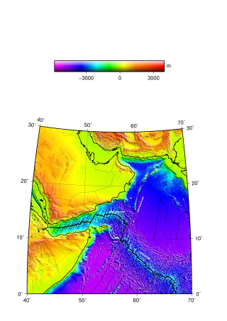
The Aden Ridge is a part of an active oblique rift system located in the Gulf of Aden, between Somalia and the Arabian Peninsula to the north. The rift system marks the divergent boundary between the Somali and Arabian tectonic plates, extending from the Owen Transform Fault in the Arabian Sea to the Afar Triple Junction or Afar Plume beneath the Gulf of Tadjoura in Djibouti.
The Aden–Owen–Carlsberg triple junction (AOC), also known as the Arabia–India–Somalia triple junction, is a triple junction that connects the Aden Ridge, Owen Fracture Zone, and Carlsberg Ridge in the northwest Indian Ocean. It has been described as one of only three RRF (ridge–ridge–fault) triple junctions on Earth, besides the Azores triple junction and Chile triple junction. However, because the fault arm of such unstable triple junctions tend to evolve into a spreading centre, all three cases have quickly evolved into stable RRR triple junctions.
The Central Indian Ridge (CIR) is a north–south-trending mid-ocean ridge in the western Indian Ocean.

The Rodrigues triple junction (RTJ), also known as the central Indian [Ocean] triple junction (CITJ) is a geologic triple junction in the southern Indian Ocean where three tectonic plates meet: the African plate, the Indo-Australian plate, and the Antarctic plate. The triple junction is named for the island of Rodrigues which lies 1,000 km (620 mi) north-west of it.

The Southwest Indian Ridge (SWIR) is a mid-ocean ridge located along the floors of the south-west Indian Ocean and south-east Atlantic Ocean. A divergent tectonic plate boundary separating the Somali plate to the north from the Antarctic plate to the south, the SWIR is characterised by ultra-slow spreading rates (only exceeding those of the Gakkel Ridge in the Arctic) combined with a fast lengthening of its axis between the two flanking triple junctions, Rodrigues (20°30′S70°00′E) in the Indian Ocean and Bouvet (54°17′S1°5′W) in the Atlantic Ocean.

The Macquarie triple junction is a geologically active tectonic boundary located at 61°30′S161°0′E at which the historic Indo-Australian plate, Pacific plate, and Antarctic plate collide and interact. The term triple junction is given to particular tectonic boundaries at which three separate tectonic plates meet at a specific, singular location. The Macquarie triple junction is located on the seafloor of the southern region of the Pacific Ocean, just south of New Zealand. This tectonic boundary was named in respect to the nearby Macquarie Island, which is located southeast of New Zealand.

The 1,600 kilometres (990 mi) long Macquarie Fault Zone is a major right lateral-moving transform fault along the seafloor of the south Pacific Ocean which runs from New Zealand southwestward towards the Macquarie Triple Junction. It is also the tectonic plate boundary between the Australian plate to the northwest and the Pacific plate to the southeast. As such it is a region of high seismic activity and recorded the largest strike-slip event on record up to 23 May 1989, of at least 8.0

The North Fiji Basin (NFB) is an oceanic basin west of Fiji in the south-west Pacific Ocean. It is an actively spreading back-arc basin delimited by the Fiji islands to the east, the inactive Vitiaz Trench to the north, the Vanuatu/New Hebrides island arc to the west, and the Hunter fracture zone to the south. Roughly triangular in shape with its apex located at the northern end of the New Hebrides Arc, the basin is actively spreading southward and is characterised by three spreading centres and an oceanic crust younger than 12 Ma. The opening of the NFB began when a slab roll-back was initiated beneath the New Hebrides and the island arc started its clockwise rotation. The opening of the basin was the result of the collision between the Ontong Java Plateau and the Australian Plate along the now inactive Solomon–Vitiaz subduction system north of the NFB. The NFB is the largest and most developed back-arc basin of the south-west Pacific. It is opening in a complex geological setting between two oppositely verging subduction systems, the New Hebrides/Vanuatu and Tonga trenches and hence its ocean floor has the World's largest amount of spreading centres per area.
The 1816 North Atlantic earthquake occurred on 2 February somewhere between the Azores Islands and Lisbon, Portugal. The estimated moment magnitude 8.3–8.9 earthquake had an epicenter offshore in the Atlantic Ocean, and was felt in Lisbon at 00:40 local time. Little is known about the quake, but it is believed to be one of the largest to have struck the Atlantic.
