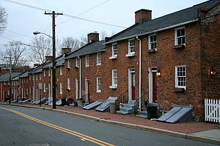
Oella is a mill town on the Patapsco River in western Baltimore County, Maryland, United States, located between Catonsville and Ellicott City. It is a 19th-century village of millworkers' homes.
Still Pond is a census-designated place in Kent County, Maryland, United States. Still Pond is located at the intersection of Maryland routes 292 and 566 on Still Pond Neck, south-southeast of Betterton and north of Chestertown. Much of the community is included in the Still Pond Historic District and it is notable as the first place in Maryland in which women gained the right to vote.

The Dorchester-Milton Lower Mills Industrial District is a historic district on both sides of the Neponset River in the Dorchester area of Boston and in the town of Milton, Massachusetts. It encompasses an industrial factory complex, most of which was historically associated with the Walter Baker & Company, the first major maker of chocolate products in the United States. The industrial buildings of the district were built between about 1868 and 1947. They were listed as part of the district on the National Register of Historic Places in 1980, with a slight enlargement in 2001. The buildings have been adapted for mixed industrial/retail/residential use.

The Clinton Village Historic District encompasses the historic portion of the town center of Clinton, Connecticut. It is roughly linear and extends along East Main Street from the Indian River in the west to Old Post Road in the east. The area represents a well-preserved mid-19th century town center, with architecture dating from the late 17th to mid-20th centuries. The district was listed on the National Register of Historic Places in 1994.

The Shepherdstown Historic District comprises the historic core of Shepherdstown, West Virginia. The town is the oldest in West Virginia, founded in 1762 as Mecklenburg. No structures are known to exist from the time before the town became known as Shepherdstown. The historic district is concentrated along German Street, the main street, with 386 contributing resources and 69 non-contributing elements. The chief representative period is the late 18th century, with many Federal style brick houses. German Street is also furnished with 19th-century "street furniture" such as metal fences, mounting blocks, wooden pumps and mature trees.

The Harpers Ferry Historic District comprises about one hundred historic structures in Harpers Ferry, West Virginia. The historic district includes the portions of the central town not included in Harpers Ferry National Historical Park, including large numbers of early 19th-century houses built by the United States Government for the workers at the Harpers Ferry Armory. Significant buildings and sites include the site of the Armory, the U.S Armory Potomac Canal, the Harpers Ferry Train Station, and Shenandoah Street, Potomac Street, and High or Washington Street. The National Historic Park essentially comprises the lower, flood-prone areas of the town, while the Historic District comprises the upper town.

The Easton Historic District is a historic district that covers most of the core of the town of Easton, Maryland. The town is the county seat of Talbot County. The state of Maryland is nearly split by the Chesapeake Bay, and Easton is located on the east side of the bay that is known as Maryland's Eastern Shore. Although the town is part of the east coast of the United States, the region's history goes back to a time when Maryland was a colonial province of England.

The Hebron Village Historic District encompasses the heart of the small town of Hebron, New Hampshire. The district was listed on the National Register of Historic Places in 1985. Multiple buildings of the district were added to the New Hampshire State Register of Historic Places in 2016.

The Bennington Village Historic District of Bennington, New Hampshire encompasses the 19th-century center of the village. Growth of the village followed a typical pattern for rural New Hampshire towns, based in this case around the growth in the early 19th century of the paper industry, which continues to be a significant economic force in the community. The district is centered on the junctions of Main, Center, and School Streets with Bible Hill Road and Francestown Road. The district was listed on the National Register of Historic Places in 2010.

The North Charlestown Historic District encompasses a 19th-century rural village in Charlestown, New Hampshire. Located about 5 miles (8 km) north of the town's center, the district includes a small cluster of buildings along New Hampshire Route 12A that is a remnant portion of a larger agricultural village. First settled in the 1750s, the oldest buildings in the district date to the 1790s, and most of the major buildings were built in the 19th century. Its economy was based on lumber and farming. The village was once considered a much larger, dispersed settlement, but construction of New Hampshire Route 11 in the 1960s separated some of the more remote parts of the village from its nucleus, which was bypassed by that construction.

The Broad Street Historic District encompasses a significant portion of the historic center of Bethel, Maine. Broad Street dates to the early days of Bethel's settlement in the early 19th century, and its town common was a gift from the first settler of the area. As originally listed on the National Register of Historic Places in 1977, the district included the common and a section of Broad Street between Main Street and Paradise Hill Road. This was expanded in 1990 along Church Street to encompass historic homes and a portion of the Gould Academy campus.

The Putney Village Historic District encompasses most of the main village and town center of Putney, Vermont. Settled in the 1760s, the village saw its major growth in the late 18th and early 19th century, and includes a cohesive collection with Federal and Greek Revival buildings, with a more modest number of important later additions, including the Italianate town hall. The district was listed on the National Register of Historic Places in 1986.

The South Londonderry Village Historic District encompasses a significant portion of the historic developed area of the village of South Londonderry, Vermont. The village has a well-preserved mid-19th century core, with most of its major development history taking place between about 1806 and 1860. The district was listed on the National Register of Historic Places in 1986.

The Wilmington Village Historic District encompasses a significant portion of the village center of Wilmington, Vermont. The village grew as a crossroads industrial center through the mid-19th century, and experienced relatively little growth afterward. The district was listed on the National Register of Historic Places in 1980.

The Bethel Village Historic District encompasses the historic core of the village of Bethel in the town of Bethel, Vermont, USA. The L-shaped district extends along Main and Church Streets, including many of the village's commercial and civic buildings, as well as a significant number of 19th and early 20th-century residences. The district was listed on the National Register of Historic Places in 1976, and was slightly enlarged in 1990.

The Stockbridge Common Historic District encompasses the central portion of a rural 19th-century village center in Stockbridge, Vermont. Including the town common as well as a few buildings and an adjacent cemetery, it is a well-preserved example of a village bypassed by economic development during the 19th century industrial period. It was listed on the National Register of Historic Places in 1990.

The Jericho Village Historic District encompasses the historic industrial and commercial center of the village of Jericho, Vermont. Stretched along Vermont Route 15 south of Browns River, which powered the village's industries for many years, the village center includes a well-preserved array of 19th and early 20th-century buildings. The district was listed on the National Register of Historic Places in 1992.

The Plainfield Village Historic District encompasses a significant portion of the village of Plainfield, Vermont. Located in northernmost Plainfield on United States Route 2, the village grew in the 19th century as a mill town and service community for the surround agricultural areas, and has a well-preserved collection of Greek Revival and Italianate architecture. It was listed on the National Register of Historic Places in 1983.

The Downtown Hardwick Village Historic District encompasses a significant portion of the downtown area of Hardwick, Vermont. The town developed in the 19th century first as a small industrial center, and later became one of the world's leading processors of granite. The district was listed on the National Register of Historic Places in 1982.

Guilford Historic Town Center is a large historic district encompassing the entire town center of Guilford, Connecticut, United States. It is centered on the town green, laid out in 1639, and extends north to Interstate 95, south to Long Island Sound, west to the West River, and east to East Creek. It includes more than 600 historic structures, most built between the late 17th and early 20th centuries, reflecting the town's growth and history during that time. It was listed on the National Register of Historic Places in 1976.


