
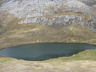
Kunka is a mountain in the La Raya mountain range in the Andes of Peru. It is situated at the La Raya Pass and the road and rail which connect Cusco with Lake Titicaca. It is located in the Cusco Region, Canas Province, Layo District, and in the Puno Region, Melgar Province, Santa Rosa District, and about 5,200 metres (17,060 ft) high. Kunka lies southwest of the mountains Yana Khuchilla and Chimpulla. Other neighboring mountains are Huch'uy K'uchu north of it and Hatun Ichhuna Kunka in the south. Between the road and the mountain is a small lake, Q'umirqucha.
Vela Cunca is a mountain in the Carabaya mountain range in the Andes of Peru, about 5,350 metres (17,552 ft) high. It is located in the Puno Region, Carabaya Province, on the border of the districts Macusani and Ollachea. Vela Cunca lies northwest of the mountain Allincapac.
Chupika is a mountain in the Cusco Region in the Andes of Peru, about 5,061.8 metres (16,607 ft) high. It is situated in the Canchis Province, on the border of the districts Checacupe and Pitumarca.
Wari Kunka is a 5,120-metre-high (16,798 ft) mountain in the Andes of Bolivia. It is situated in the La Paz Department, José Manuel Pando Province, at the border of the Catacora Municipality and the Santiago de Machaca Municipality. Wari Kunka lies southeast of Patapatani, northeast of Sinijawi and southeast of Jisk'a Wari Kunka. An intermittent stream named Salla Uma originates southwest of the mountain. It flows to the west where it meets Jaruma River as a left tributary.
Huilacunca is a mountain in the Vilcanota mountain range in the Andes of Peru, about 5,100 metres (16,732 ft) high. It is situated in the Puno Region, Carabaya Province, Corani District. Huilacunca lies northeast of the mountains Jatuncucho and Jonorana.
Q'atawini is a mountain in the Andes of Peru, about 4,800 metres (15,748 ft) high. It is located in the Puno Region, Lampa Province, on the border of the districts Cabanilla and Santa Lucía.
Wari Kunka is a mountain in the Andes of Peru, about 4,800 metres (15,748 ft) high. It is situated in the Puno Region, El Collao Province, Santa Rosa District. It lies northeast of the lake Lurisquta, northwest of the mountain Janq'u Q'awa.
Kuntur Wawachawi is a mountain in the Andes of Peru, about 5,000 metres (16,404 ft) high. It is situated in the Puno Region, El Collao Province, Santa Rosa District. Kuntur Wawachawi lies east of the lake Lurisquta, between the mountain Wari Kunka in the southeast and Jach'a K'uchu in the northwest.
Ojecunca is a mountain in the Vilcanota mountain range in the Andes of Peru, about 5,000 metres (16,404 ft) high. It is located in the Cusco Region, Canchis Province, in the districts of Checacupe and San Pablo. Ojecunca lies southwest of Jampatune and Pomanota. The Pumanuta River, an important tributary of the Vilcanota River, flows along its southern slope.
Saxa Q'awa is a mountain in the Wansu mountain range in the Andes of Peru, about 5,000 metres (16,404 ft) high. It is situated in the Arequipa Region, Condesuyos Province, Cayarani District. Saxa Q'awa lies south of Janq'u Q'awa between the Puma Ranra valley in the west and a lake name Anqasqucha in the east.
Taypi Q'awa is a mountain in the Wansu mountain range in the Andes of Peru, about 5,000 m (16,404 ft) high. It is located in the Arequipa Region, La Unión Province, Puyca District, east of Ikmaqucha.
Taypi Kunka is a mountain in the Andes of Peru, about 4,800-metre (15,700 ft) high. It is located in the Puno Region, Carabaya Province, Crucero District. Taypi Kunka lies at a lake named Wiluyuq Qucha, northwest of Apachita and northeast of Pinkilluni Urqu.
Wila Kunka is a mountain in the Cusco Region in the Andes of Peru, about 5,000 m (16,000 ft) high. It is situated in the Canchis Province, Checacupe District. Wila Kunka lies at the left bank of the Chawchamayu (Chauchamayo), northwest of Qusqu Qhawarina.
K'ank'awi is a mountain in the Andes of southern Peru, about 5,300 m (17,400 ft) high. It is located in the Tacna Region, Candarave Province, Candarave District. K'ank'awi lies southwest of Larqanku and Jisk'a Larqanku.
K'ank'awini is a 5,275-metre-high (17,306 ft) mountain in the Andes of southern Peru. It is situated in the Moquegua Region, Mariscal Nieto Province, Torata District. K'ank'awini lies west of Apachita Limani.
Chuqi Quta is a mountain in the Andes of Peru, about 5,200 metres (17,060 ft) high. It is located in the Puno Region, El Collao Province, Santa Rosa District. It lies southwest of Jisk'a Mawruma.
Sukata Laq'a is a mountain in the Andes of Peru, about 5,100 metres (16,732 ft) high. Sukata Laq'a is located in the Puno Region, El Collao Province, Santa Rosa District. It lies southwest of Chuqi Quta and northwest of Chuta Kunka.
Chuta Kunka is a mountain in the Andes of Peru, about 5,000 metres (16,404 ft) high. It is located in the Puno Region, El Collao Province, Santa Rosa District, southeast of Sukata Laq'a and Chuqi Quta.
Janq'u Q'awa is a mountain in the Andes of Peru, about 4,800 m (15,700 ft) high. It is located in the Cusco Region, Espinar Province, on the border of the districts of Condoroma and Ocoruro. Janq'u Q'awa lies southwest of Isankani and Aqhu Phichaqa.
Jupa Tawqaña or Jupa Tawqana is a mountain in the Wallanka mountain range in the Andes of Peru which reaches an altitude of approximately 4,800 m (15,700 ft). It is located in the Ancash Region, Bolognesi Province, Aquia District. Jupay Tawqaña lies at the Kinwa Raqra valley northeast of Kinwa Quta.
