Adams County is a county in the U.S. state of Washington. As of the 2010 census, the population was 18,728. The county seat is at Ritzville, and its largest city is Othello. The county was formed out of Whitman County in November 1883 and is named for the second President of the United States, John Adams.

Adams County is a county located in the U.S. state of Colorado. As of the 2020 census, the population was 519,572. The county seat is Brighton. The county is named for Alva Adams, an early Governor of the State of Colorado in 1887–1889. Adams County is part of the Denver–Aurora–Lakewood, CO Metropolitan Statistical Area.

Lincoln County is a county located in the U.S. state of Washington. As of the 2010 census, the population was 10,570, making it the fifth-least populous county in the state. The county seat and largest city is Davenport.

Franklin County is a county located in the U.S. state of Washington. As of the 2010 census, its population was 78,163. The county seat and largest city is Pasco. The county was formed out of Whitman County on November 28, 1883, and is named for Benjamin Franklin.

Davenport is the county seat of Lincoln County, Washington, United States. The population was 1,734 at the 2010 census.

The Inland Northwest, historically and alternatively known as the Inland Empire, is a region of the American Northwest centered on the Greater Spokane, Washington Area, encompassing all of Eastern Washington and Northern Idaho. Under broader definitions, Northeastern Oregon and Western Montana may be included in the Inland Northwest. Alternatively, stricter definitions may exclude Central Washington and Idaho County, Idaho.
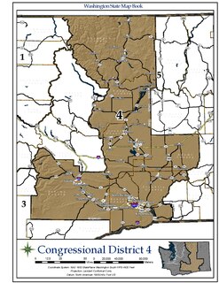
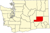
Washington's 4th congressional district encompasses a large area of central Washington, covering the counties of Douglas, Okanogan, Grant, Yakima, Franklin, Benton, and Adams, and part of Walla Walla County. The district is dominated by the Yakima and Tri-Cities areas. The Fourth District is predominantly rural, and is considerably more conservative than the western part of the state: it is in fact the most Republican district in the Pacific States.
There are over 30 lakes named Mud Lake within the U.S. state of Washington.
East Adams Rural Healthcare is a twenty-bed Critical Access Hospital located in Ritzville, Washington, at the junction of Interstate 90 and US Route 395. Adams County Public Hospital District #2 operates the hospital in Ritzville, as well as medical clinics in Ritzville and Washtucna, and is associated with the Ritzville, Lind, and Washtucna Volunteer Ambulance Associations. Together, these organizations serve a 1,500 square miles (3,900 km2) area of eastern Adams County, Washington, and a district population of about 3,900. The hospital emergency department is a Level V Trauma Care Center, a Level II Cardiac Center, and a Level III Stroke Center; it serves its community, as well as accident victims from the adjacent major highways.

The Kettle River Range, often called the Kettle Range, is the southernmost range of the Monashee Mountains, located in far southeastern British Columbia, Canada and Ferry County, Washington, in the United States. Most of the northern half of the range is protected by the Colville National Forest and the southern half of the range is located on the Colville Indian Reservation. The highest peak is Copper Butte, which reaches 2,177 metres (7,142 ft). The range is crossed by Washington State Route 20 at Sherman Pass.

The Ritzville Historic District, located in Ritzville, Washington, is a district listed on the National Register of Historic Places. The district encompasses 3 blocks of Ritzville's main business district and contains 27 contributing and 11 noncontributing properties.
Washington's 9th Legislative District is one of forty-nine districts in Washington state for representation in the state legislature. The sprawling rural district includes all of Adams, Asotin, Franklin, Garfield, and Whitman counties as well as parts of Spokane County. The district resides in the extreme southeast of the state, bordering Oregon to the south and Idaho to the east.
Ruff is an unincorporated community in Grant County, in the U.S. state of Washington.
Paha is an unincorporated community in Adams County, Washington, United States. It is located along BNSF Railway's Lakeside Subdivision. Paha is assigned the ZIP code 99169.
Ralston is an unincorporated community in Adams County, Washington, United States. Ralston is assigned the ZIP code 99169.
Roxboro is an unincorporated community in Adams County, Washington, United States. Its ZIP code is 98857 and is named after Roxboro, Massachusetts.
Ankeny was a town in Adams County, Washington. The GNIS classifies it as a populated place.
Rockwell was a town in Adams County, Washington. The GNIS classifies it as a populated place.
Servia was a town in Adams County, Washington. The GNIS classifies it as a populated place.
Weber is an unincorporated community in Adams County, in the U.S. state of Washington.