Paddington Water Tower

Last updated

Paddington Water Tower
Paddington Water Tower, June 2019, 03.jpg
Paddington Water Tower, 2019
Location16 Garfield Drive, Paddington, City of Brisbane, Queensland, Australia
Coordinates 27°27′32″S152°59′22″E / 27.4589°S 152.9895°E / -27.4589; 152.9895 Coordinates: 27°27′32″S152°59′22″E / 27.4589°S 152.9895°E / -27.4589; 152.9895
Design period1919 - 1930s (interwar period)
Built1927
Architect Metropolitan Water Supply & Sewerage Board
Official namePaddington Water Tower
Typestate heritage (built)
Designated23 June 2000
Reference no.601831
Significant period1927 (fabric)
1910s-1930s (historical)
Significant componentspump house, tower - water
Buildersday labour
Australia Queensland location map.svg
Red pog.svg
Location of Paddington Water Tower in Queensland
Australia location map.svg
Red pog.svg
Paddington Water Tower (Australia)

Paddington Water Tower is a heritage-listed water tower at 16 Garfield Drive, Paddington, City of Brisbane, Queensland, Australia. It was designed by Metropolitan Water Supply & Sewerage Board and built by day labour in 1927. It was added to the Queensland Heritage Register on 23 June 2000. [1]

Contents

History

By the beginning of the 20th century, Brisbane was drawing most of its water from the Brisbane River at Mount Crosby. Enoggera Dam and Gold Creek Dam were also feeding into the system. At this stage none of the supplies were filtered and Brisbane's water supply was neither treated nor tested until the first decade of the twentieth century. [1]

In 1907, American hydraulic engineer, Allen Hazen, was engaged by the Brisbane Board of Waterworks to report on the amplification of Brisbane's supply. He recommended against the construction of a dam on the Brisbane River in its middle catchment because of his perception of the danger of rapid loss of storage capacity because of siltation. He recommended storage on Cabbage Tree Creek, a tributary of the Brisbane River, some 19 kilometres (12 mi) upstream of Mount Crosby and further recommended the site of the Somerset Dam on the Stanley River for future amplification of storage. [1]

From about 1916, the shape of Mount Crosby and nearby Holt's Hill underwent a series of changes with structures erected, extended and demolished in response to the water quality demands of Brisbane, and after 1922, of Ipswich. [1]

To provide facilities to residents on elevated land for a full water supply, service reservoirs were constructed at Bartley's Hill in 1907 and 1919, Enoggera in 1912, Holt's Hill in 1919, Tarragindi in 1923, Paddington in 1927, Roles Hill in 1928, Eildon Hill in 1930, Bulimba in 1940, Sparkes Hill in 1941 and Bracken Ridge in 1944. Previous service reservoirs had been constructed at Wickham Terrace in 1870 and 1882, Highgate Hill in 1889 and the Mount Crosby High Level in 1891. [1]

Supplying water to the higher parts of Paddington had always been difficult, so it was a great benefit to residents when the Water Board opened this tower in 1927 which was fed from Enoggera Dam. The Board had striven for 12 years to obtain the £ 12,000 necessary to build the Paddington Tower. The Tower was dedicated on 4 March 1927 and was officially opened by Mr Ernest James Theodore Manchester, President of the Metropolitan Water Supply and Sewerage Board, with members of the board and local residents in attendance. The tower was described as the finest piece of work constructed by any authority and at the time was the most expensive single structure ever to have been constructed in the Town of Ithaca. [1]

At the opening the President said it had always been the aim of the Water Board to afford facilities to provide a full water supply to all residents on elevated land and that in time he hoped to see all elevated lands graced by water towers. The power for the motor which hoisted the water into the tank was switched on by Mr J J Roberts who referred to Paddington Heights as the Dress Circle of Brisbane. [1]

The structure was designed by the Board's engineer and erected by the board's staff with day labour on a site 335 feet (102 m) above sea level. The tank is composed of reinforced concrete and the height from the highest point is 70 feet (21 m). It is capable of holding 100,000 imperial gallons (450,000 l; 120,000 US gal). The Tramway Department provided the electricity required for the centrifugal pump which propelled water from the tank below [1]

A cottage was erected alongside the tank on the vacant piece of ground shortly after the tower was opened so that the turncock would live on the premises and give every attention to see that the tank was constantly well filled with water. [1]

Description

Macgregor Terrace in Bardon (Paddington Water Tower on left horizon), circa 1929 Macgregor Terrace in Bardon (Paddington Water Tower on left horizon), circa 1929.JPG
Macgregor Terrace in Bardon (Paddington Water Tower on left horizon), circa 1929

Paddington Water Tower is located on a 529-square-metre (5,690 sq ft) allotment on Archibald's Hill. The site slopes northward away from Garfield Terrace down to Tooth Avenue. The Tower is located adjacent to the Garfield Terrace boundary with the pump house adjacent to its western side. [1]

Paddington Water Tower is surplus to water supply requirements and is no longer in use. It is essentially unaltered from its original appearance. Located on Archibald's Hill, it is one of Brisbane's oldest and most prominent landmarks. It is probably the only one of its type in Queensland being a reinforced concrete tank elevated on concrete columns. [1]

Of the other service reservoirs erected in Brisbane, Wickham Terrace (1870 & 1882), Mount Crosby High Level (1891), Holt's Hill (1919) and Bulimba (1940) are also now surplus to requirements and not in use. [1]

The Paddington tank and its tower are of reinforced concrete construction The circular tank is supported on a structural framework of twelve columns and octagonal grids of haunched beams. The water tower is 70 feet (21 m) high and the tank has a capacity of 100,000 imperial gallons (450,000 l; 120,000 US gal) and the top water level is 335 feet (102 m) AHD. [1]

The tower is a prominent Brisbane landmark in the north western suburbs. It is visible from miles around and most vantage points and is readily recognisable. [1]

Heritage listing

Paddington Water Tower was listed on the Queensland Heritage Register on 23 June 2000 having satisfied the following criteria. [1]

The place is important in demonstrating the evolution or pattern of Queensland's history.

Paddington Water Tower is important in demonstrating a phase in the history of Brisbane's water supply and the technological difficulties of providing reticulated water to elevated sites. [1]

The place demonstrates rare, uncommon or endangered aspects of Queensland's cultural heritage.

The Paddington Water Tower is a rare example of an elevated reinforced concrete water tank. It is probably the only one of its type in Queensland being a reinforced concrete tank elevated on concrete columns. [1]

The place is important because of its aesthetic significance.

The Paddington Water Tower is important for its aesthetic qualities as a readily recognisable landmark. It is one of Brisbane's most prominent landmarks. [1]

Related Research Articles

Paddington, Queensland Suburb of Brisbane, Queensland, Australia

Paddington is an inner suburb in the City of Brisbane, Queensland, Australia. In the 2016 census, Paddington had a population of 8,562 people.

Enoggera Reservoir, Queensland Suburb of Brisbane, Queensland, Australia

Enoggera Reservoir is an outer north-western suburb in the City of Brisbane, Queensland, Australia. In the 2016 census, Enoggera Reservoir had a population of 25 people.

Mount Crosby Pumping Station

Mount Crosby pumping station is a heritage-listed pumping station and weir at Stumers Road, Mount Crosby, City of Brisbane, Queensland, Australia. It is located on the Brisbane River and extends into Chuwar on the other side of the river. The facility supplies water to Brisbane and nearby cities and towns within the SEQ Water Grid. It was originally designed by Charles H McLay and built from 1891 to 1892. The historic parts of the facility were added to the Queensland Heritage Register on 25 October 2019. It is also listed on the Brisbane Heritage Register, together with numerous associated facilities which were not included in the state heritage listing.

Enoggera Dam Dam in South East Queensland

The Enoggera Dam is a heritage-listed dam, which is located within the outer, western suburb of Enoggera Reservoir, in Brisbane, Queensland, Australia.

Gold Creek Dam Dam in South East Queensland

The Gold Creek Dam is an earth-fill embankment dam with an un-gated spillway across the Gold Creek that is located in the South East region of Queensland, Australia. The main purpose of the dam is for potable water supply of the Brisbane region. The resultant reservoir is called the Gold Creek Reservoir.

Lake Manchester Dam Dam in South East Queensland

The Lake Manchester Dam is a concrete gravity dam with an un-gated spillway across the Cabbage Tree Creek that is located in the South East region of Queensland, Australia. The main purpose of the dam is for potable water supply of Brisbane. The impounded reservoir is called Lake Manchester.

Mount Crosby Weir Dam in South East Queensland

The Mount Crosby Weir is a heritage-listed weir on the Brisbane River at Mount Crosby and Chuwar, both in City of Brisbane, Queensland, Australia. The project was instigated by John Petrie at the end of the 19th century. The town of Brisbane was expanding and seeking more reliable sources of drinking water than Enoggera Dam and Gold Creek Dam could provide. In conjunction with the Mount Crosby Pumping Station, it was listed on the Queensland Heritage Register on 25 October 2019.

City of Brisbane Local government area in Queensland, Australia

The City of Brisbane is a local government area (LGA) which comprises the inner portion of the metropolitan area of Brisbane, the capital of Queensland, Australia. Its governing body is the Brisbane City Council. Unlike LGAs in the other mainland state capitals, which are generally responsible only for the central business districts and inner neighbourhoods of those cities, the City of Brisbane administers a significant portion of the Brisbane metropolitan area, serving almost half of the population of the Brisbane Greater Capital City Statistical Area (GCCSA). As such, it has a larger population than any other local government area in Australia. The City of Brisbane was the first Australian LGA to reach a population of more than one million. Its population is roughly equivalent to the populations of Tasmania, the Australian Capital Territory and the Northern Territory combined. In 2016–2017, the council administered a budget of over $3 billion, by far the largest budget of any LGA in Australia.

Spring Hill Reservoirs

The Spring Hill Reservoirs are two heritage-listed former underground water storage reservoirs within Wickham Park at 230 Wickham Terrace, Spring Hill, City of Brisbane, Queensland, Australia. They are also known as Service Reservoirs. They were added to the Queensland Heritage Register on 21 October 1992.

Ithaca Town Council Chambers

The Ithaca Town Council Chambers is a heritage-listed former town hall of the former local government area of the Town of Ithaca, and now a community centre in Paddington, City of Brisbane, Queensland, Australia. Located at 99 Enoggera Terrace, Red Hill, it was designed by Atkinson and McLay and built in 1910 by Charles Thomas Hall and Francis Joseph Mayer. It is also known as Ithaca Library and Red Hill Kindergarten. It was added to the Queensland Heritage Register on 24 March 2000.

Ithaca War Memorial

Ithaca War Memorial and Park is a heritage-listed memorial and park at Enoggera Terrace, Paddington, Queensland, Australia. The memorial was designed and built by Arthur Henry Thurlow between 1921 and 1925. The park was built and designed by Alexander Jolly. It is also known as Alexander Jolly Park. It was added to the Queensland Heritage Register on 21 October 1992.

Ithaca Fire Station

Ithaca Fire Station is a heritage-listed fire station at 140 Enoggera Terrace, Paddington, Queensland, Australia. It was designed by station superintendent Alfred Joseph Harper and built in 1918-1919; an upper level was designed by Atkinson, Powell and Conrad and built by Frederick Enchelmaier in 1928. It was added to the Queensland Heritage Register on 2 March 1993.

Torbreck, Brisbane

Torbreck, or the Torbreck Home Units, was the first high-rise and mix-use residential development in Queensland, Australia. These heritage-listed home units are located at 182 Dornoch Terrace, Highgate Hill, Brisbane. Designed by architects Aubrey Horswill Job and Robert Percival Froud, construction began in 1957 and was completed three years later in 1960 by Noel Austin Kratzmann. The project acquired the name 'Torbreck' to recognise a small, gabled timber cottage that previously occupied the site. It was added to the Queensland Heritage Register on 17 December 1999.

Mount Coot-tha Forest

Mount Coot-tha Forest is a heritage-listed forest reserve at Sir Samuel Griffith Drive, Mount Coot-tha, City of Brisbane, Queensland, Australia. It is also known as Mount Coot-tha Reserve. It was added to the Queensland Heritage Register on 4 September 2007.

Paddington Tramways Substation

Paddington Tramways Substation is a heritage-listed former electrical substation at 150 Enoggera Terrace, Paddington, City of Brisbane, Queensland, Australia. It was designed by Roy Rusden Ogg and built from 1929 to 1930. It was added to the Queensland Heritage Register on 22 March 1993.

Innisfail Water Tower

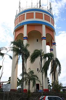
Innisfail Water Tower is a heritage-listed water tower at Mourilyan Street, East Innisfail, Cassowary Coast Region, Queensland, Australia. It was built from 1933 to 1934 by Van Leeuwen Brothers. It was added to the Queensland Heritage Register on 6 August 2010.

Bankstown Reservoir Water tower in Bankstown, Sydney, NSW

Bankstown Reservoir is a heritage-protected water tower and a local landmark situated in the suburb of Bankstown, Sydney, New South Wales, Australia. Located 22 kilometres (14 mi) west of Sydney CBD, the reservoir is elevated and was built on reinforced concrete piers, which is one of the oldest of this type that is still in use. The reservoir features various decorative attributes, plastered by hand, which lack in other functional reservoirs. Established in 1920, the reservoir serves a large area of South-Western Sydney.

Drummoyne Reservoir

Drummoyne Reservoir is a heritage-listed decommissioned elevated service reservoir at Rawson Avenue, Drummoyne, City of Canada Bay, New South Wales, Australia. It was designed by engineer J. G. S. Purvis from the Metropolitan Board of Water Supply and Sewerage and built from 1910 to 1913, with the Board responsible for the construction of the substructure and Poole & Steele Ltd responsible for the tank manufacture. It is also known as WS0038 and Drummoyne Elevated Steel Reservoir. It was added to the New South Wales State Heritage Register on 15 November 2002. The property was owned by Sydney Water having been sold in September 2018.

Penshurst Reservoirs

The Penshurst Reservoirs are heritage-listed reservoirs located at Laycock Road, Penshurst in the Georges River Council local government area of New South Wales, Australia. They were designed and built during 1895 by the NSW Public Works Department. The reservoirs are also known as WS87 & R88, Penshurst Elevated Steel Reservoir No 2 and Penshurst Elevated Concrete Reservoir No 3. The property is owned by Sydney Water, an agency of the Government of New South Wales. The site was added to the New South Wales State Heritage Register on 18 November 1999.

Waterworks Road Arterial road in Brisbane, Australia

Waterworks Road is an 8.5 km (5.3 mi) arterial road in Brisbane, Queensland, Australia. It is currently signed as State Route 31 for its entire length. Waterworks Road transports traffic between the Brisbane central business district and western suburbs such as Red Hill, Ashgrove and The Gap.

References

  1. 1 2 3 4 5 6 7 8 9 10 11 12 13 14 15 16 17 18 "Paddington Water Tower (entry 601831)". Queensland Heritage Register . Queensland Heritage Council. Retrieved 1 August 2014.

Attribution

CC-BY-icon-80x15.png This Wikipedia article was originally based on "The Queensland heritage register" published by the State of Queensland under CC-BY 3.0 AU licence (accessed on 7 July 2014, archived on 8 October 2014). The geo-coordinates were originally computed from the "Queensland heritage register boundaries" published by the State of Queensland under CC-BY 3.0 AU licence (accessed on 5 September 2014, archived on 15 October 2014).