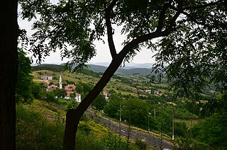
Padina | |
---|---|
Village | |
Coordinates: 41°30′00″N25°04′01″E / 41.5°N 25.067°E | |
Country | |
Province | Kardzhali Province |
Municipality | Ardino |
Area | |
• Total | 10.411 km2 (4.020 sq mi) |
Elevation | 650 m (2,130 ft) |
Population (2007) | |
• Total | 1,030 |
Time zone | EET (UTC+2) |
• Summer (DST) | EEST (UTC+3) |
Padina (Bulgarian : Падина) is a village in Ardino Municipality, Kardzhali Province, southern-central Bulgaria, located in a valley at the foot of Mount St. Elias (1001m). It is located 195.32 kilometres (121.37 mi) from Sofia,14.8 kilometres (9.2 mi) southwest of Ardino, and 4.8 kilometres (3.0 mi) by road south of Byal izvor. [1] It covers an area of 10.411 square kilometres and as of 2007 had a population of 1030 people, although the population is rapidly declining and 851 were reported in 2010. [2]
Bulgarian, is an Indo-European language and a member of the Southern branch of the Slavic language family.
Ardino Municipality is a municipality in Kardzhali Province, Bulgaria. It includes the town of Ardino and 51 nearby villages.
Kardzhali District is a province of southern Bulgaria, neighbouring Greece with the Greek regional units of Xanthi, Rhodope, and Evros to the south and east. It is 3209.1 km² in area. Its main city is Kardzhali.
Padina has a continental Mediterranean climate, with a climate which is characterized by mild, humid winters and hot, dry summers. Crops include tobacco and potatoes, and small areas are favorable for growing sugar beets, strawberries and some vegetables ( tomatoes, peppers, beans, etc.). Over the last decades, several apple orchards have been established. The village operates a dairy farm that produces high quality cheese, yogurt, butter, melted and smoked cheese and curd. Padina has a primary school, kindergarten and community centre with a library.
Tobacco is a product prepared from the leaves of the tobacco plant by curing them. The plant is part of the genus Nicotiana and of the Solanaceae (nightshade) family. While more than 70 species of tobacco are known, the chief commercial crop is N. tabacum. The more potent variant N. rustica is also used around the world.
The potato is a starchy, tuberous crop from the perennial nightshade Solanum tuberosum. In many contexts, potato refers to the edible tuber, but it can also refer to the plant itself. Common or slang terms include tater, tattie and spud. Potatoes were introduced to Europe in the second half of the 16th century by the Spanish. Today they are a staple food in many parts of the world and an integral part of much of the world's food supply. As of 2014, potatoes were the world's fourth-largest food crop after maize (corn), wheat, and rice.
The tomato is the edible, often red, berry of the plant Solanum lycopersicum, commonly known as a tomato plant. The species originated in western South America. The Nahuatl word tomatl gave rise to the Spanish word tomate, from which the English word tomato derived. Its use as a cultivated food may have originated with the indigenous peoples of Mexico. The Spanish encountered the tomato from their contact with the Aztec during the Spanish colonization of the Americas and brought it to Europe. From there, the tomato was introduced to other parts of the European-colonized world during the 16th century.
Avramovo is a village in Ardino Municipality, Kardzhali Province, in southern-central Bulgaria. It is located 187.5 kilometres (116.5 mi) from Sofia, roughly 14 kilometres (8.7 mi) by road southwest of the city of Kardzhali, and roughly 20 kilometres (12 mi) by road east of the municipal town of Ardino.Boyno lies just to the east along the 865 road. It covers an area of 6.197 square kilometres (2.393 sq mi) and as of 2007 had a population of 6 people. Until 1934, the settlement had the name Ibrahimler.
Chubrika is a village in Ardino Municipality, Kardzhali Province, southern-central Bulgaria. It is located 199.97 kilometres (124.26 mi) from Sofia, roughly 21.3 kilometres (13.2 mi) by road southwest of the city of Kardzhali, and roughly 13 kilometres (8.1 mi) by road east of the municipal town of Ardino. To the north is Yabalkovets and to the northeast is Kobilyane, along the 865 road. It covers an area of 5.782 square kilometres (2.232 sq mi) and as of 2007 had a population of 153 people. It was formerly called Fakrŭ Bunar.
Yabalkovets is a mountain village in Ardino Municipality, Kardzhali Province, southern-central Bulgaria. It is located 199.97 kilometres (124.26 mi) from Sofia, and roughly 16 kilometres (9.9 mi) by road northeast of the municipal town of Ardino. To the southeast is Chubrika. It covers an area of 11.232 square kilometres and as of 2013 had a population of 204 people.
Mak is a small hamlet in Ardino Municipality, Kardzhali Province, southern-central Bulgaria. It is located 201.18 kilometres (125.01 mi) from Sofia. It lies at altitude of 561 metres (1,841 ft) to the southeast of Ardino and Sinchets, east of Gurbishte and southwest of Tsarkvitsa. It covers an area of 5.642 square kilometres and as of 2007 had a population of 1 person. The hamlet is dependent on Gurbishte for village functions, where there is also a village hall.
Sinchets is a small mountain village in Ardino Municipality, Kardzhali Province, southern-central Bulgaria. It is located 199.967 kilometres (124.254 mi) from Sofia. It lies at altitude of 770 metres (2,530 ft), 9.8 kilometres (6.1 mi) by winding road to the southeast of Ardino, and north of Tsarkvitsa. It covers an area of 8.602 square kilometres and as of 2007 had a population of 70 people.
Gurbishte is a mountain village in Ardino Municipality, Kardzhali Province, southern-central Bulgaria. It is located 196.78 kilometres (122.27 mi) from Sofia and 13.6 kilometres (8.5 mi) by winding road south of Ardino. It lies to the southwest of Sinchets, and northeast of Padina. It covers an area of 14.494 square kilometres and as of 2007 had a population of 183 people. The village contains a village hall.
Ahryansko is a village in Ardino Municipality, Kardzhali Province, southern-central Bulgaria. It is located 191.083 kilometres (118.733 mi) from Sofia. It covers an area of 6.839 square kilometres and as of 2007 had a population of 51 people.
Bashevo is a village in Ardino Municipality, Kardzhali Province, southern-central Bulgaria. It is located 187.489 kilometres (116.500 mi) from Sofia. It covers an area of 4.647 square kilometres and as of 2007 had a population of 168 people.
Bogatino is a village in Ardino Municipality, Kardzhali Province, southern-central Bulgaria. It is located 200.247 kilometres (124.428 mi) from Sofia. It covers an area of 2.258 square kilometres and as of 2007 had a population of 114 people.
Brezen is a village in Ardino Municipality, Kardzhali Province, southern-central Bulgaria. It is located 193.057 kilometres (119.960 mi) from Sofia. It covers an area of 7.21 square kilometres and as of 2007 had a population of 243 people.
Chernigovo is a village in Ardino Municipality, Kardzhali Province, southern-central Bulgaria. It is located 188.663 kilometres (117.230 mi) from Sofia. It covers an area of 1.384 square kilometres and as of 2007 had a population of 62 people.
Glavnik is a village in Ardino Municipality, Kardzhali Province, southern-central Bulgaria. It is located 200.247 kilometres (124.428 mi) from Sofia. It covers an area of 1.795 square kilometres and as of 2007 had a population of 127 people.
Golobrad is a village in Ardino Municipality, Kardzhali Province, southern-central Bulgaria. It is located 193.057 kilometres (119.960 mi) from Sofia. It covers an area of 3.547 square kilometres and as of 2007 had a population of 151 people.
Dyadovtsi is a village in Ardino Municipality, Kardzhali Province, southern-central Bulgaria. It is located 192.06 kilometres (119.34 mi) from Sofia. It covers an area of 6.025 square kilometres and as of 2007 had a population of 85 people.
Iskra is a village in Ardino Municipality, Kardzhali Province, southern-central Bulgaria. It is located 192.036 kilometres (119.326 mi) southeast of Sofia. It covers an area of 1.884 square kilometres and as of 2007 it had a population of 65 people.
Kitnitsa is a village in Ardino Municipality, Kardzhali Province, southern-central Bulgaria. It is located 188.619 kilometres (117.202 mi) southeast of Sofia. It covers an area of 11.586 square kilometres and as of 2007 it had a population of 97 people.
Kroyachevo is a village in Ardino Municipality, Kardzhali Province, southern-central Bulgaria. It is located 193.336 kilometres (120.133 mi) southeast of Sofia. It covers an area of 5.183 square kilometres and as of 2007 it had a population of 104 people.
Latinka is a village in Ardino Municipality, Kardzhali Province, southern-central Bulgaria. It is located 193.336 kilometres (120.133 mi) southeast of Sofia. It covers an area of 10.652 square kilometres and as of 2007 it had a population of 22 people.
Levtsi is a village in Ardino Municipality, Kardzhali Province, southern-central Bulgaria. It is located 200.247 kilometres (124.428 mi) southeast of Sofia. It covers an area of 2.112 square kilometres and as of 2007 it had a population of 56 people.
Lenishte is a village in Ardino Municipality, Kardzhali Province, southern-central Bulgaria. It is located 201.18 kilometres (125.01 mi) southeast of Sofia. It covers an area of 13.487 square kilometres and as of 2007 it had a population of 122 people.
Wikimedia Commons has media related to Padina, Kurdjali District . |
This Kardzhali Province, Bulgaria location article is a stub. You can help Wikipedia by expanding it. |