
Montana Province is a province in northwestern Bulgaria, bordering Serbia in the southwest and Romania in the north. It spreads its area between the Danube river and Balkan mountain. As of February 2011, the province has a population of 148,098 inhabitants, on territory of 3,635.5 km². It was named after its administrative centre the city of Montana.

Dobrich Province is a province in northeastern Bulgaria, part of Southern Dobruja geographical region. It is bounded on east by the Black Sea, on south by Varna Province, on west by Yambol & Sliven provinces, on north by Shumen & Varna provinces. It is divided into 8 municipalities. At the 2011 census, it had a population of 186,016.
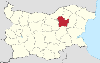
Targovishte Province is a province in northeastern Bulgaria, named after its main city - Targovishte. As of December 2009, it has a population of 129,675 inhabitants.

Opaka is a town in Targovishte Province in northeast Bulgaria. As of December 2009, the town had a population of 2,873 and covers an area of 57 square kilometres (22 sq mi). It is 70 kilometres (43 mi) south of the city of Rousse on the border with Romania and 250 kilometres (160 mi) northeast of the Bulgarian capital, Sofia. Archeologists have found evidence of Thracian, Roman and Slavonic settlements in the area. Near the village of Krepcha, a stone monastery is the site of the oldest known Old Bulgarian Cyrillic inscription, dated from around 920 CE. A 2nd century Thracian tumulus containing various artifacts, including six leaves of a golden wreath and bronze figurines, was excavated in 2011.

Shabla is a town and seaside resort in northeastern Bulgaria, administrative centre of the Shabla Municipality part of Dobrich Province. Shabla municipality includes the following villages: Bojanovo, Chernomortsi, Durankulak, Ezerets, Gorichane, Gorun, Granichar, Krapets, Prolez, Smin, Staevtsi, Tvarditsa, Tyulenovo, Vaklino and Zahari Stoyanovo. As of December 2009, the town itself had a population of 3,586 inhabitants. It is situated on the Bulgarian Black Sea Coast in the vicinity of the salt-water Lake Shabla and Bulgaria's easternmost point, Cape Shabla.
Zlatitsa is a town and the seat of the Zlatitsa Municipality in southern Bulgaria located in the Zlatitsa-Pirdop valley. It lies between Stara Planina to the north and Sredna Gora to the south at 680 metres (2,230 ft) above sea level. It is situated immediately south in the lap of the Zlatitsa -Teteven Mountain. Zlatitsa is situated 75 kilometres (47 mi) east of Sofia, 27 kilometres (17 mi) south of Etropole, 32 kilometres (20 mi) north of Panagiurishte, 2 kilometres (1.2 mi) west of Pirdop and 32 kilometres (20 mi) northwest of Koprivshtitsa. The population is 5,286.
Gulyantsi is a town in central northern Bulgaria, part of Pleven Province. It is the administrative centre of Gulyantsi municipality and lies in the central north of the province, near the town of Nikopol, very close to the Danube River. As of December 2009, the town has a population of 3,432 inhabitants.

Sungurlare is a town in southeastern Bulgaria, part of Burgas Province. It is the administrative centre of Sungurlare municipality, which lies in the northwestern part of Burgas Province.

Kocherinovo is a town in southwestern Bulgaria, part of Kyustendil Province. It is the administrative centre of Kocherinovo Municipality, which lies in the southern part of Kyustendil Province. As of 2013 it has 2,255 inhabitants.
Vetovo is a town in northeastern Bulgaria, part of Ruse Province. It is the administrative centre of Vetovo Municipality, which lies in the eastern part of the area, and ranks third in population in the province after Ruse and Byala. The town is located 40 kilometres away from the provincial capital - Ruse. As of December 2009, Vetovo has a population of 4,777 inhabitants.

Smyadovo is a town in eastern Bulgaria, part of Shumen Province. It is the administrative centre of the homonymous Smyadovo Municipality, which lies in the southeastern part of the province. As of December 2009, the town has a population of 4,036 inhabitants.
Dalgopol is a town in northeastern Bulgaria, part of Varna Province. It is the administrative centre of Dalgopol Municipality, which lies in the southwestern part of the Province. As of December 2009, the town has a population of 4,829 inhabitants.
Suvorovo is a town in northeastern Bulgaria, part of Varna Province. It is the administrative centre of the homonymous Suvorovo Municipality, which lies in the northwestern part of the Province. The town is located in the southwestern part of the Dobruja plateau, 34 kilometres (21 mi) northwest of the provincial capital of Varna, 56 kilometres (35 mi) southwest of Dobrich and 59 kilometres (37 mi) east of Shumen. As of December 2009, it has a population of 4,723 inhabitants.
Dimovo is a town in northwestern Bulgaria, part of Vidin Province. It is the administrative centre of the homonymous Dimovo Municipality, which lies in the eastern part of Vidin Province, 30 kilometres from Vidin at the Danube and 50 kilometres from Bregovo at the Timok River and the Serbian border. As of December 2009, Dimovo has a population of 1,211 inhabitants.

Altimir Glacier is a 4.8-kilometre (3.0 mi) long and 5.5-kilometre (3.4 mi) wide glacier draining the north slopes of the Osterrieth Range on Anvers Island in the Palmer Archipelago, Antarctica. It flows northwards to enter Dalchev Cove in Fournier Bay east of Studena Point.
Zahari Stoyanovo may refer to the following places in Bulgaria:
Stoyanovo is a village in Varshets Municipality, Montana Province, northwestern Bulgaria.
Stoyanovo may refer to the following places in Bulgaria:


