
Opaka is a town in Targovishte Province in northeast Bulgaria. As of December 2009, the town had a population of 2,873 and covers an area of 57 square kilometres (22 sq mi). It is 70 kilometres (43 mi) south of the city of Rousse on the border with Romania and 250 kilometres (160 mi) northeast of the Bulgarian capital, Sofia. Archeologists have found evidence of Thracian, Roman and Slavonic settlements in the area. Near the village of Krepcha, a stone monastery is the site of the oldest known Old Bulgarian Cyrillic inscription, dated from around 920 CE. A 2nd century Thracian tumulus containing various artifacts, including six leaves of a golden wreath and bronze figurines, was excavated in 2011.
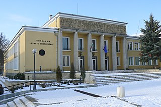
Zlatitsa is a town and the seat of the Zlatitsa Municipality in southern Bulgaria located in the Zlatitsa-Pirdop valley. It lies between Stara Planina to the north and Sredna Gora to the south at 680 metres (2,230 ft) above sea level. It is situated immediately south in the lap of the Zlatitsa -Teteven Mountain. Zlatitsa is situated 75 kilometres (47 mi) east of Sofia, 27 kilometres (17 mi) south of Etropole, 32 kilometres (20 mi) north of Panagiurishte, 2 kilometres (1.2 mi) west of Pirdop and 32 kilometres (20 mi) northwest of Koprivshtitsa. The population is 5,286.

Klisura is a small town in the Karlovo Municipality of the Plovdiv Province in central Bulgaria. It is situated in a valley surrounded by the Balkan Mountain range and Sredna Gora. As of 2005, its population has numbered 1,478 people and it is located 105 km to the east of Sofia, 35 km west of Karlovo and 25 km northeast of Koprivshtitsa.
Aksakovo is a town in Varna Province, Northeastern Bulgaria. It is the administrative centre of the homonymous Aksakovo Municipality. The town is located on the Franga Plateau three kilometres northwest of the city of Varna. As of December 2009, it has a population of 7,897 inhabitants.

Trastenik is a town in central northern Bulgaria, part of Dolna Mitropoliya municipality, Pleven Province. It lies 18 kilometres northwest of Pleven and 30 kilometres south of the Danube, between the Vit and Iskar rivers.
Gulyantsi is a town in central northern Bulgaria, part of Pleven Province. It is the administrative centre of Gulyantsi municipality and lies in the central north of the province, near the town of Nikopol, very close to the Danube River. As of December 2009, the town has a population of 3,432 inhabitants.

Kocherinovo is a town in southwestern Bulgaria, part of Kyustendil Province. It is the administrative centre of Kocherinovo Municipality, which lies in the southern part of Kyustendil Province. As of 2013 it has 2,255 inhabitants.
Valchedram is a town in northwestern Bulgaria, part of Montana Province. It is the administrative centre of Valchedram Municipality, which lies in the northeastern part of Montana Province. As of December 2009, the town has a population of 3,817 inhabitants.
Iskar is a town in central northern Bulgaria, part of Pleven Province. It is the administrative centre of Iskar Municipality, which lies in the western part of the Province. The town of Iskar is located in the central Danubian Plain, near the Iskar River, 18 kilometres from Knezha and 32 kilometres from the provincial capital of Pleven. As of December 2009, the town has a population of 3,622 inhabitants.
Zavet is a town in northeastern Bulgaria, part of Razgrad Province and located in the geographic region of Ludogorie. It is the administrative centre of the homonymous Zavet Municipality, which lies in the northern part of Razgrad Province. Zavet is situated in the western Ludogorie Plateau, 12 kilometres from Isperih and Kubrat and 35 kilometres from Tutrakan and Razgrad.
Vetovo is a town in northeastern Bulgaria, part of Ruse Province. It is the administrative centre of Vetovo Municipality, which lies in the eastern part of the area, and ranks third in population in the province after Ruse and Byala. The town is located 40 kilometres away from the provincial capital - Ruse. As of December 2009, Vetovo has a population of 4,777 inhabitants.
Polski Trambesh is a town in central northern Bulgaria, part of Veliko Tarnovo Province. It is the administrative centre of the homonymous Polski Trambesh Municipality, which lies in the northeastern part of the Province. The town is located 36 kilometres from the provincial capital of Veliko Tarnovo, 45 km from Svishtov, 35 km from Pavlikeni, 33 km from Gorna Oryahovitsa, 22 km from Byala, Rousse Province and 40 km from Strazhitsa. As of December 2009, Polski Trambesh has a population of 4,546 inhabitants.

Krivodol is a town in northwestern Bulgaria, part of Vratsa Province. It is the administrative centre of Krivodol municipality, which lies in the western part of Vratsa Province, halfway between Vratsa and Montana and 130 kilometres north of Sofia

Rogozen Island is a conspicuous island off the northwest coast of Robert Island, South Shetland Islands situated 920 m (1,010 yd) north-northeast of Cornwall Island, 470 m (510 yd) south-southwest of Heywood Island, and 1.74 km (1.08 mi) northwest of Svetulka Island in the Onogur group. Extending 760 m (830 yd) in east-west direction and 260 m (280 yd) wide. Surface area 16 hectares.
Onogur Islands is the group of nine islands and some islets and rocks adjacent to the northwest coast of Robert Island in the South Shetland Islands, Antarctica. The group is situated between Carlota Cove to the southwest and Clothier Harbour to the northeast, and 700 m (770 yd) southeast of Cornwall Island. Kovach Island and Grod Island, the largest two in the group, have a surface area of 11 hectares and 10 hectares respectively. The area was visited by early 19th century sealers based in Clothier Harbour.
Gurbishte is a mountain village in Ardino Municipality, Kardzhali Province, southern-central Bulgaria. It is located 196.78 kilometres (122.27 mi) from Sofia and 13.6 kilometres (8.5 mi) by winding road south of Ardino. It lies to the southwest of Sinchets, and northeast of Padina. It covers an area of 14.494 square kilometres and as of 2007 had a population of 183 people. The village contains a village hall.
Komuniga is a village in Chernoochene Municipality, in Kardzhali Province, in southern-central Bulgaria. It is located 185.772 kilometres (115.433 mi) southeast of Sofia. It covers an area of 26.665 square kilometres and as of 2007 it had a population of 1150 people.
Shipot Point is the ice-free point on the northwest coast of Robert Island in the South Shetland Islands projecting 630 m northwards, and together with Osenovlag Island and Svetulka Island forming the southwest side of Clothier Harbour. The area was visited by early 19th century sealers.


