
Peng Chau is a small island located off the north-eastern coast of Lantau Island, Hong Kong. It is known locally for its temples, fishing industry and seafood.
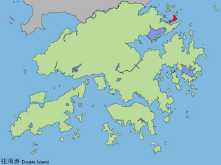
Double Island or Wong Wan Chau is an island located in the north-eastern part of Hong Kong. Administratively, it is part of North District.

Hei Ling Chau, formerly Hayling Chau, is an island of Hong Kong, located east of Silver Mine Bay and Chi Ma Wan of Lantau Island. It is administratively part of the Islands District.

The Ninepin Group or Kwo Chau Islands (果洲群島) is a group of 29 islands in the easternmost waters of Hong Kong. The Ninepin Group falls under the jurisdiction of Sai Kung District of Hong Kong.
Tsing Chau or Pillar Island was an island in the Kwai Chung area of Hong Kong, sitting at the mouth of Gin Drinker's Bay, by the side of the Rambler Channel, opposite Tsing Yi Island.

Nga Ying Chau, or Cap Island, was an island off the northeast shore of Tsing Yi Island of Hong Kong, separated by a small harbour, Mun Tsai Tong, with Tsuen Wan at its northeast, just across the Rambler Channel. When the small harbour was reclaimed for the development of a new town, the island became part of Tsing Yi Island. The island was once home to the CRC Oil Storage Depot, which later relocated to the other side of Tsing Yi Island owing to its proximity to the residential area. The former island is now a small hill on the northeast point of Tsing Yi Island, and Villa Esplanada, a private housing estate, stands on the hills.

Chau Tsai was a small island off the southern shore of Nam Wan Kok on Tsing Yi Island, Hong Kong. It was also known as Chun Fa Rock, or Chung Hue Shik (春花石) in some historical documents. The island was merged with Tsing Yi Island by land reclamation for the construction of the CRC Oil Storage Depot.
Ap Chau Mei Pak Tun Pai is a small island in the New Territories of Hong Kong. It is located in Ap Chau Bay (鴨洲海) just off the southern tip of Ap Chau (鴨洲) and is not to be confused with Ap Chau Pak Tun Pai (鴨洲白墩排) which is located further west. It is under the administration of North District.
Ap Chau Pak Tun Pai is a small island in the New Territories of Hong Kong. It is located in Ap Chau Bay (鴨洲海) to the west of Ap Chau and is not to be confused with Ap Chau Mei Pak Tun Pai which is located closer to Ap Chau. It is under the administration of North District.
Ap Lo Chun is a small island in the New Territories of Hong Kong. It is located in Ap Chau Bay (鴨洲海) between Ap Chau (鴨洲) in the east and Sai Ap Chau in the west, with the islet of Ap Tan Pai (鴨蛋排) nearby in the northeast. It is under the administration of North District.
Ap Tan Pai is a small island in the New Territories of Hong Kong. It is located in Ap Chau Bay (鴨洲海) between Ap Chau (鴨洲) to the east and Ap Lo Chun (鴨籮春) to the southwest. It is under the administration of North District.
Ap Tau Pai is a small island between Yan Chau Tong and Crooked Harbour in the north-eastern New Territories of Hong Kong. It is located in Ap Chau Bay (鴨洲海), North-east of Hong Kong. It is under the administration of North District.
Rocky Harbour or Leung Shuen Wan Hoi is a harbour at the south-east of Sai Kung Peninsula, Hong Kong.

Tang Lung Chau is a small island located off the south coast of Ma Wan to the north-west of Hong Kong Island, Hong Kong. It is administratively part of Tsuen Wan District.

Port Shelter, known in Cantonese as Ngau Mei Hoi, is a harbour south of Sai Kung Peninsula in Hong Kong. The water body connects to Inner Port Shelter, as well as Hebe Haven (白沙灣), Rocky Harbour (糧船灣海) and other water body. Outer Port Shelter, is situated at the mouth of the harbour.

Ma Shi Chau Special Area is a Special Area of Hong Kong. It is located in Tai Po District and in Tolo Harbour, in the northeast of the New Territories.
Wang Chau is an island of Hong Kong. Administratively it is part of Sai Kung District.

Centre Island aka. A Chau is a small uninhabited island of Hong Kong located in Tolo Harbour, in the northwestern part of the territory. Administratively, it is part of Tai Po District.

Crescent Island or Ngo Mei Chau is an island of Hong Kong, located southeast of Crooked Island and northeast of Double Island. Administratively, it is part of North District.

Yeung Chau is an uninhabited island of Hong Kong located in Plover Cove, Tolo Harbour, in the northwestern part of the territory. Administratively, it is part of Tai Po District.
This page is based on this
Wikipedia article Text is available under the
CC BY-SA 4.0 license; additional terms may apply.
Images, videos and audio are available under their respective licenses.

