
Andrew Geddes Bain, was a South African geologist, road engineer, palaeontologist and explorer.

The Continental Divide National Scenic Trail is a United States National Scenic Trail with a length measured by the Continental Divide Trail Coalition of 3,028 miles (4,873 km) between the U.S. border with Chihuahua, Mexico and the border with Alberta, Canada. Frequent route changes and a large number of alternate routes result in an actual hiking distance of 2,700 miles (4,300 km) to 3,150 miles (5,070 km). The CDT follows the Continental Divide of the Americas along the Rocky Mountains and traverses five U.S. states — Montana, Idaho, Wyoming, Colorado, and New Mexico. In Montana near the Canadian border the trail crosses Triple Divide Pass.

Wupperthal is a small town in the Cederberg mountains in the Western Cape province of South Africa. It was founded in 1830 by two German missionaries of the Rhenish Missionary Society, Theobald von Wurmb and Johann Gottlieb Leipoldt, grandfather of C. Louis Leipoldt – some 100 years before the city of Wuppertal was formally established in Germany. In 1965, after the Rhenish Mission had gradually scaled down their activities in Southern Africa over a period of 40 years, a decision was taken that Wupperthal in future should become part of the Moravian Church, which by that stage had already made the transition from a mission to an autonomous church in South Africa. The town remains a Moravian mission station to this day.
The South African Air Force (SAAF) is the air warfare branch of South African National Defence Force, with its headquarters in Pretoria. The South African Air Force was established on 1 February 1920. The Air Force saw service in World War II and the Korean War. From 1966, the SAAF was involved in providing infantry support in the low-intensity Border War in Angola, South-West Africa and Rhodesia. As the war progressed, the intensity of air operations increased, until in the late 1980s when the SAAF were compelled to fly fighter missions against Angolan aircraft in order to maintain tactical air superiority. On conclusion of the Border War in 1990, aircraft numbers were severely reduced due to economic pressures as well as the cessation of hostilities with neighbouring states.

The Cederberg mountains are located near Clanwilliam, approximately 300 km north of Cape Town, South Africa at about 32°30′S19°0′E. The mountain range is named after the endangered Clanwilliam cedar, which is a tree endemic to the area. The mountains are noted for dramatic rock formations and San rock art. The Cederberg Wilderness Area is administered by CapeNature.

The Swartberg mountains are a mountain range in the Western Cape province of South Africa. It is composed of two main mountain chains running roughly east–west along the northern edge of the semi-arid Little Karoo. To the north of the range lies the other large semi-arid area in South Africa, the Great Karoo. Most of the Swartberg Mountains are above 2000 m high, making them the tallest mountains in the Western Cape. It is also one of the longest, spanning some 230 km from south of Laingsburg in the west to between Willowmore and Uniondale in the east. Geologically, these mountains are part of the Cape Fold Belt.
The R364 is a Regional Route in South Africa that connects Lamberts Bay to the R27 between Calvinia and Nieuwoudtville via Clanwilliam.

The Tsitsikamma National Park is a protected area on the Garden Route, Western Cape and Eastern Cape, South Africa. It is a coastal reserve well known for its indigenous forests, dramatic coastline, and the Otter Trail. On 6 March 2009 it was amalgamated with the Wilderness National Park and various other areas of land to form the Garden Route National Park.

The Cape Fold Belt is a fold and thrust belt of late Paleozoic age, which affected the sequence of sedimentary rock layers of the Cape Supergroup in the southwestern corner of South Africa. It was originally continuous with the Ventana Mountains near Bahía Blanca in Argentina, the Pensacola Mountains, the Ellsworth Mountains and the Hunter-Bowen orogeny in eastern Australia. The rocks involved are generally sandstones and shales, with the shales persisting in the valley floors while the erosion resistant sandstones form the parallel ranges, the Cape Fold Mountains, which reach a maximum height of 2325 m at Seweweekspoortpiek.

Bontebok National Park is a species-specific national park in South Africa. It was established in 1931 to ensure the preservation of the Bontebok. It is the smallest of South Africa's 18 National Parks, covering an area of 27.86 km2 The park is part of the Cape Floristic Region, which is a World Heritage Site.

The Table Mountain Sandstone (TMS) is a group of rock formations within the Cape Supergroup sequence of rocks. Although the term "Table Mountain Sandstone" is still widely used in common parlance, the term TMS is no longer formally recognized; the correct name is the "Peninsula Formation Sandstone", which is part of the Table Mountain Group. The designation "Table Mountain Sandstone" will, however, in deference to the title, continue to be used in the rest of this article. The name is derived from the famous landmark in Cape Town, Table Mountain.

Sir Lowry's Pass is a mountain pass on the N2 national road in the Western Cape province of South Africa. It crosses the Hottentots Holland Mountains between Somerset West and the Elgin valley, on the main route between Cape Town and the Garden Route. A railway line also crosses the mountain range near this point.
Mpofu Nature Reserve is a nature reserve in the Amatole district of the Eastern Cape Province, South Africa that is managed by Eastern Cape Parks.

The Swartberg Pass on the R328 runs over the Swartberg mountain range which runs roughly east–west along the northern edge of the semi-arid area called the Little Karoo in the Western Cape province of South Africa. It's the only road access to Gamkaskloof.

A long-distance trail is a longer recreational trail mainly through rural areas used for hiking, backpacking, cycling, horse riding or cross-country skiing. They exist on all continents except Antarctica.
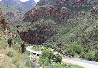
Meiringspoort is a South African mountain pass on the N12 national road, where it crosses the Swartberg mountain range.
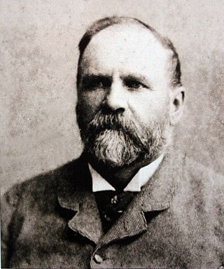
Thomas Charles John Bain was a South African road engineer. As a prolific road building pioneer, Bain was responsible for the planning and construction of more than 900 km of roads and mountain passes, many of them still in use today, over a career spanning from 1848 until 1888. These passes through the mountain ranges between the thin coastal plain and the interior of the former Cape Colony in South Africa, played a major role in opening up the vast hinterland of South Africa.

Biedouw Valley is a valley situated in the Western Cape province of South Africa at an elevation of 376 m. It is located near Pakhuis Pass, between Clanwilliam and Uitspankraal.

Breccia Peak is a mountain in the southern Absaroka Range of the Rocky Mountains. It is located in Teton County in the U.S. state of Wyoming, close to the southwest border of the Teton Wilderness within the Bridger-Teton National Forest.

Seven Passes Road is the oldest direct road link between George and Knysna in Western Cape, South Africa. The road which traverses seven passes was engineered by Thomas Charles John Bain and Adam de Smidt. It was completed around 1883 and is situated just south of the Outeniqua Mountains.
