
The river Ticino is the most important perennial left-bank tributary of the Po. It has given its name to the Swiss canton through which its upper portion flows.
The Aosta Valley is a mountainous autonomous region in northwestern Italy. It is bordered by Auvergne-Rhône-Alpes, France, to the west; by Valais, Switzerland, to the north; and by Piedmont, Italy, to the south and east. The regional capital is Aosta.

Courmayeur is a town and comune in northern Italy, in the autonomous region of Aosta Valley.

Brusson is a town and comune in the Ayas Valley, a left side valley of the Aosta Valley region in Italy.
La Magdeleine is a town and comune in the Aosta Valley region of north-west Italy.

Breuil-Cervinia, officially Le Breuil from September 2023, is a frazione of the comune of Valtournenche, Italy. It is a winter and summer tourist resort.

Theodul Pass, elevation 3,295 metres (10,810 ft), is a high mountain pass across the eastern Pennine Alps, connecting Zermatt in the Swiss canton of Valais and Breuil-Cervinia in the Italian region of Aosta Valley. Theodul Pass is the lowest and the easiest pass between the valleys of Zermatt and Valtournanche.

Punta Tre Vescovi is a peak in the Biellese Prealps, in northern Italy. On its top, three valleys meet: Lys Valley, Valsesia, and Cervo Valley.

Pizzo Coca is a mountain that straddles the Val Seriana and the Valtellina in Lombardy, Italy. It is the highest peak in the Bergamo Alps. Its height is 3,050 metres with a prominence height of 1,878 metres and a saddle of 1,172 metres. A post-glacial valley exists near a point called Ometto in sassi at 2,400 meters.

Refuge Crête Sèche or Rifugio Crête Sèche is a shelter in the Alps of Italy near the border with Switzerland. More precisely, this refuge is located in the valley of Valpelline, a side valley of the Aosta Valley in the Italian Pennine Alps, at 2,410 metres (7,910 ft) above sea level. It lies on the slopes of Mont de Crête Sèche whose summit is at elevation 2,941 metres (9,649 ft).

The Miage Glacier is a debris-covered glacier in the upper Aosta Valley, in northwestern Italy.
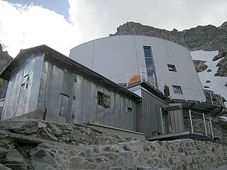
The Gonella Hut is a high elevation mountain hut in the Aosta Valley in the Mont Blanc massif area of the Alps. It lies at an elevation of 3071 metres, above Val Veny near Courmayeur in Italy. The refuge is located on the Italian 'normal route' to Mont Blanc.
Monte Cresto (2,548 m) is the third highest peak of the Province of Biella after Monte Mars (2,600 m) and Monte Bo (2,556 m).

The Garda Mountains, occasionally also the Garda Hills, are an extensive mountain range of the Southern Limestone Alps in northern Italy.

The Passo dei Salati is a mountain pass that lies between the Valsesia (Piedmont) and the Valley of Lys. It connects the villages of Alagna Valsesia and Gressoney-La-Trinité. The pass has also been known as the Colle Inferiore de Pisse. The term salati recalls an ancient passage of Roman soldiers.

Val Vogna is a lateral valley of Valsesia, inside the municipality of Riva Valdobbia, Italy.

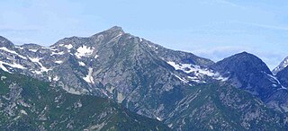
Corno Bussola is a 3,023 metres high peak on the Italian side of the Pennine Alps.

The Punta Leynir is a 3,238 metres high mountain belonging to the Italian side of Graian Alps.

The Brenva Glacier is a valley glacier, located on the southern side of the Mont Blanc massif in the Alps. It is the second longest and eighth largest glacier in Italy, and descends down into Val Veny, close to Entrèves, near Courmayeur. Over the centuries it has experienced a number of major rock avalanches which have shaped the glacier and influenced its movement.

Monte Mucrone is an Alpine mountain of Piedmont.

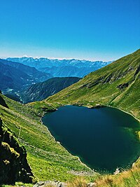
![Lac Long (2,633 m [8,638 ft]) Lago Lungo (Brusson).jpg](http://upload.wikimedia.org/wikipedia/commons/thumb/f/fa/Lago_Lungo_%28Brusson%29.jpg/296px-Lago_Lungo_%28Brusson%29.jpg)


![The Palasinaz Pass (2,668 m [8,753 ft]) Colle Palasina.jpg](http://upload.wikimedia.org/wikipedia/commons/thumb/7/74/Colle_Palasina.jpg/180px-Colle_Palasina.jpg)
![Lac de la Bataille (2,487 m [8,159 ft]) Lago della Battaglia.jpg](http://upload.wikimedia.org/wikipedia/commons/thumb/a/ae/Lago_della_Battaglia.jpg/300px-Lago_della_Battaglia.jpg)
![Lac Vert (2,485 m [8,153 ft]) Lago Verde (Laghi Palasinaz).jpg](http://upload.wikimedia.org/wikipedia/commons/thumb/d/d1/Lago_Verde_%28Laghi_Palasinaz%29.jpg/180px-Lago_Verde_%28Laghi_Palasinaz%29.jpg)
 Connection between Lago della Battaglia and Lac Vert.
 Lac Vert (2485 m), Val d'Ayas, Italy.
 Lac du Couloir (2606 m)
 Corno Bussola (Mont de Boussolaz, 3022 m)
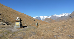 Palasinaz Peak top view from Estoul.
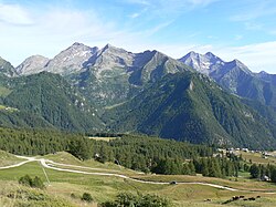 Estoul, start of the excursion to Refuge Arp.
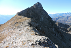 Corno Bussola ridge from the East
 Lac Vert, seen from below


