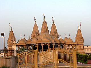
Bharuch, formerly known as Broach, is a city at the mouth of the river Narmada in Gujarat in western India. Bharuch is the administrative headquarters of Bharuch District.

The Mahi is a river in western India. It rises in Madhya Pradesh and, after flowing through the Vagad region of Rajasthan, enters Gujarat and flows into the Arabian Sea. It is one of the relatively few west-flowing rivers in India, alongside the endorheic Luni River, the Sabarmati River, the Tapi River and the Narmada River. Most peninsular rivers in India flow eastward into the Bay of Bengal or northward into the Ganges River.
Radhanpur is a town and a municipality in Patan district in the Indian state of Gujarat.
Chandravati, popularly known as Chandroti, is a village situated near Abu Road on the bank of the West Banas River in the Indian state of Rajasthan. In ancient times it was an extensive town, and present villages such as Dattani, Kiverli, Kharadi and Santpura were its suburbs. The old ruins, such as temples, torans and images scattered over the large area, bear testimony to its past glory.
Kankrej thana or Kankrej Estates was a former collection of native states in what is now part of Banaskantha district of Gujarat, India.
Varsoda is a small village located in Mansa, Gujarat, on the bank of the Sabarmati River, formerly the seat of an eponymous Rajput princely state. It is approximately 25 kilometres (16 mi) from Gandhinagar, the state capital of Gujarat.

Sathamba is a town located in Aravali district of the Indian state of Gujarat and the seat of a former petty princely state. It has a population of approximately 15,000.

South Gujarat, also known as Dakshin Gujarat, is a region in the Indian state of Gujarat. The region has a wetter climate than other regions of Gujarat. The western part is almost coastal and is known as Kantha Vistar, and the eastern part is also known as Dungar Vistar, which ranges from 100 to 1000 metres, with the highest peak at Saputara in the Dang district.
Pethapur State was a small princely state belonging to the Mahi Kantha Agency of the Bombay Presidency during the era of the British Raj. It was centered on Pethapur village, in present-day Gandhinagar district of Gujarat State, a place renowned for block-making.
Ramas is a town and former Makwana Koli princely state in Mahi Kantha.
Suigam was a village in Vav Taluka of Maratha Riyasat in Gujarat, India, but it is now a Taluka of Banaskantha district in Gujarat.
Tervada is a village in Kankrej Taluka of Banaskantha district in Gujarat, India.
Bhabhar is a town in the Banaskantha district of Gujarat, India.
Kakar is a village in Kankrej Taluka of Banaskantha district in Gujarat, India.
Sami is a town in Sami Taluka of Patan district of Gujarat, India.
Maguna is a town in the Mehsana district of Gujarat in western India.
Mota Kotarna is a village in the Mehsana district of Gujarat in western India.
Dadhalia is a town and former Rajput princely state in Gujarat, western India.
Jagana is a village in the Palanpur taluka of Banaskantha district in northern Gujarat, India. The villages Vasna, Bhagal, Sedrasana are located near to Jagana and it is just 6 km away from the district headquarters, Palanpur.
Palej railway station is a railway station on the Western Railway network in the state of Gujarat, India. Palej railway station is 26 km far away from Bharuch railway station. Passenger, MEMU and few Express/Superfast trains halt at Palej railway station.


