
Palisades State Park is a state park of South Dakota, USA, featuring cliffs and rock formations eroded out of pink Sioux Quartzite. The park is located just south of Garretson, 10 miles (16 km) off Interstate 90. At only 157 acres (64 ha), it is South Dakota's second-smallest state park.

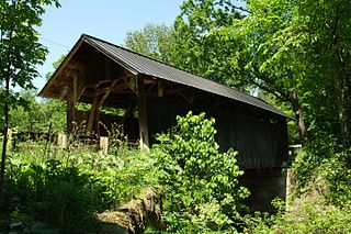
The Wilkins Mill Covered Bridge is north of Rockville, Indiana, United States. The single span Burr Arch Truss covered bridge structure was built by William Hendricks in 1906. The bridge is 120 feet (37 m) long, 16 feet (4.9 m) wide, and 13 feet (4.0 m) high.

The Stewart Creek Bridge or Bridge L6007 is a stone arch bridge in the Smithville neighborhood of Duluth, Minnesota, United States. It was built around 1925 as part of the scenic Skyline Parkway overlooking the city. The Stewart Creek Bridge was listed on the National Register of Historic Places in 1989 under the name Bridge No. L-6007 for its state-level significance in the theme of engineering. It was nominated for being the most picturesque stone arch road bridge in design and setting in Minnesota.

The US 41–Fanny Hooe Creek Bridge is a highway bridge located on US Highway 41 (US 41) over the Fanny Hooe Creek about one mile east of Copper Harbor, adjacent to Fort Wilkins State Park, in Grant Township, Michigan. It was listed on the National Register of Historic Places in 1999.

The Minidoka Project is a series of public works by the U.S. Bureau of Reclamation to control the flow of the Snake River in Wyoming and Idaho, supplying irrigation water to farmlands in Idaho. One of the oldest Bureau of Reclamation projects in the United States, the project involves a series of dams and canals intended to store, regulate and distribute the waters of the Snake, with electric power generation as a byproduct. The water irrigates more than a million acres (4,000 km²) of otherwise arid land, producing much of Idaho's potato crop. Other crops include alfalfa, fruit and sugar beets. The primary irrigation district lies between Ashton in eastern Idaho and Bliss in the southwestern corner of the state. Five main reservoirs collect water, distributing it through 1,600 miles (2,600 km) of canals and 4,000 miles (6,400 km) of lateral distribution ditches.

The Christine Falls Bridge is a reinforced concrete arch bridge in Mount Rainier National Park, spanning Van Trump Creek at Christine Falls. The bridge was built in 1927–1928 by contractor J. D. Tobin of Portland, Oregon, who built the Narada Falls Bridge at the same time. The arch has a three-centered profile and spans 56 feet (17 m). The bridge is 30 feet (9.1 m) wide. It was faced with rubble stonework and is an example of National Park Service Rustic design.

The St. Andrews Creek Bridge was built in 1930-31 as part of the West Side Road in Mount Rainier National Park. The bridge spans 26 feet (7.9 m) and is almost 34 feet (10 m) wide, carrying a two-lane road on a stone-faced concrete bridge. The West Side Road was planned to link the Nisqually and Carbon River entrances to the park, but only 13 miles (21 km) were completed in six years.
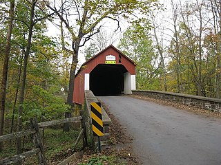
The Seguin Covered Bridge, also called the Upper Covered Bridge and the Sequin Covered Bridge, is a wooden covered bridge that crosses Lewis Creek in Charlotte, Vermont on Roscoe Road. It was built about 1850, and is a distinctive variant of a Burr arch design. It was listed on the National Register of Historic Places in 1974.

The Hammond Covered Bridge is a Town lattice covered bridge spanning Otter Creek in Pittsford, Vermont. The bridge was built in 1842 by Asa Norse, and originally carried Kendall Hill Road, which now passes just to its south. The bridge was added to the National Register of Historic Places on January 21, 1974.
The Frankenfield Covered Bridge is a wooden covered bridge that spans Tinicum Creek in Point Pleasant, Pennsylvania, United States. The bridge is located in Bucks County on Cafferty Road about 0.6 miles (1.0 km) southeast of Headquarters Road, near Vansant Airport, and a similar distance northwest of East Dark Hollow Road, near Palisades School District. Hollow Horn Road branches off from Cafferty Road a short distance from the south end of the span and goes south.
The Chicagon Mine Road–Chicagon Creek Bridge is a bridge located on Chicagon Mine Road over Chicagon Creek in Bates Township, Michigan. It was listed on the National Register of Historic Places in 1999.
The Calamus Creek Bridge near Maxwell, Iowa is a concrete Luten arch bridge constructed in 1905. It was built by N. M. Stark and Company for a cost of $900. It has a 25-foot (7.6 m) single span and a total length of 45 feet (14 m).
Indian Mound Reserve is a public country park near the village of Cedarville, Ohio, United States. Named for two different earthworks within its bounds — the Williamson Mound and the Pollock Works — the park straddles Massies Creek as it flows through a small canyon.
The Miller Ree Creek Bridge is a historic bridge in Miller, South Dakota. It is a single-span Marsh rainbow arch concrete bridge, carrying 2nd Street over Ree Creek just west of the town. The bridge consists of two concrete arches, from which the floor supports are suspended. The bridge is 42 feet (13 m) long and 22 feet (6.7 m) wide, rising about 10 feet (3.0 m) above the stream bed. Built in 1914, this bridge is one of only three bridges of the type to survive in the state, and is the best-preserved of the three.
The Sylamore Creek Bridge is a historic bridge in east central Stone County, Arkansas, just south of the Ozark-St. Francis National Forest. It carries County Road 283 across Sylamore Creek, a short way west of Arkansas Highway 9 and north of the Holiday Mountain Resort in Allison. It is a wire-cable suspension bridge, with steel towers mounted on concrete piers supporting four main cables that are anchored into concrete abutments. The bridge is 202 feet (62 m) long, with a deck width of 19 feet 6 inches (5.94 m) and a clearance height of 11 feet (3.4 m). Built in 1945, it is one of three known wire-cable bridges in the state.

The Cooley Covered Bridge is a covered bridge that carries Elm Street across Furnace Brook in Pittsford, Vermont. Built in 1849, it is one of a small number of bridges in the state that has a well-documented association with the 19th-century master bridgewright Nicholas M. Powers, who grew up nearby. It is one of four surviving 19th-century covered bridges in the town, and was listed on the National Register of Historic Places in 1974.

The Marble Bridge, formally known as the Fletcher D. Proctor Memorial Bridge, carries Main Street across Otter Creek in the center of Proctor, Vermont. Built in 1915, and widened in 1935-36, it is a well-preserved example of early concrete bridge construction, and is decoratively faced in local marble. The bridge was listed on the National Register of Historic Places in 1991.

The New Haven-Weybridge Rattling Bridge is a historic bridge spanning Otter Creek between the Vermont towns of Weybridge and New Haven. It connects Town Highway 7 in New Haven with Town Highway 11 in Weybridge. Built in 1908 by the American Bridge Company, it is a well-preserved example of a rivet-connected lattice truss bridge. It was listed on the National Register of Historic Places as Bridge 26 in 2006.
The Bridge designated NEHBS No. AP00-252 near Royal, Nebraska built in 1911 was listed on the National Register of Historic Places in 1992. It brought a township road over an unnamed stream, about 6.8 miles (10.9 km) northeast of Royal. The bridge was fabricated by the Lackawanna Steel Co. and built by the Western Bridge & Construction Co. of Omaha, Nebraska at cost of $1,149. It was a Kingpost pony truss bridge with span length of 30 feet (9.1 m), total length of 32 feet (9.8 m), and roadway width of 16 feet (4.9 m).

The West Sixth Street Bridge is a historic stone arch bridge in downtown Austin, Texas. Built in 1887, the bridge is one of the state's oldest masonry arch bridges. It is located at the site of the first bridge in Austin, carrying Sixth Street across Shoal Creek to link the western and central parts of the old city. The bridge was added to the National Register of Historic Places in 2014.


