Pana, Burkina Faso

Last updated
Pana, Burkina Faso
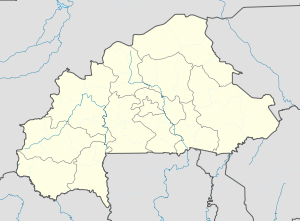
Burkina Faso location map.svg
Red pog.svg
Pana, Burkina Faso
Location in Burkina Faso
Coordinates: 11°53′N3°11′W / 11.883°N 3.183°W / 11.883; -3.183 Coordinates: 11°53′N3°11′W / 11.883°N 3.183°W / 11.883; -3.183
CountryFlag of Burkina Faso.svg  Burkina Faso
Region Boucle du Mouhoun Region
Province Balé
Department Pompoï Department
Population (1996)
  Total 812
Time zone GMT (UTC+0)

Pana, Burkina Faso is a village in the Pompoï Department of Balé Province in southern Burkina Faso, Africa. The village has a total population of 812. [1]

Pompoï Department Department in Balé, Burkina Faso

Pompoï is a department or commune of Balé Province in southern Burkina Faso. Its capital lies at the town of Pompoï. According to the 1996 census the department has a total population of 10,613.

Balé Province Province in Boucle du Mouhoun, Burkina Faso

Balé is one of the 45 provinces of Burkina Faso, located in its Boucle du Mouhoun Region with Boromo as capital. Its area is 4,595 km2 (1,774 sq mi), and in 2006 had a population of 213,897. The province is known for its Deux Balé Forest, populated by savannah elephant herds. Boromo, the provincial capital, is located on the main road from Ouagadougou to Bobo-Dioulasso. In June 2007, the Canadian mining company, Semafo, open the third gold mine in the country in Mana in the province, with an investment of about $116 million.

Burkina Faso country in Africa

Burkina Faso is a landlocked country in West Africa. It covers an area of around 274,200 square kilometres (105,900 sq mi) and is surrounded by six countries: Mali to the north; Niger to the east; Benin to the southeast; Togo and Ghana to the south; and Ivory Coast to the southwest. The July 2018 population estimate by the United Nations was 19,751,651. Burkina Faso is a francophone country, with French as the official language of government and business. Roughly 40% of the population speaks the Mossi language. Formerly called the Republic of Upper Volta (1958–1984), the country was renamed "Burkina Faso" on 4 August 1984 by then-President Thomas Sankara. Its citizens are known as Burkinabé. Its capital is Ouagadougou.
Related Research Articles

Ouagadougou City in Centre Region, Burkina Faso

Ouagadougou, also Vagaga, is the capital of Burkina Faso and the administrative, communications, cultural, and economic centre of the nation. It is also the country's largest city, with a population of 2,200,000 in 2015. The city's name is often shortened to Ouaga. The inhabitants are called ouagalais. The spelling of the name Ouagadougou is derived from the French orthography common in former French African colonies.

Provinces of Burkina Faso

The regions of Burkina Faso are divided into 45 administrative provinces. These 45 provinces are currently sub-divided into 351 departments or communes.

Milla, Burkina Faso is a village in the Tenkodogo Department of Boulgou Province in south-eastern Burkina Faso. As of 2005, the village has a population of 481.

Sport in Burkina Faso

Sport in Burkina Faso is widespread and includes football, basketball, cycling, rugby union, handball, tennis, athletics, boxing and martial arts.

Sankara, Burkina Faso is a village in the Tiéfora Department of Comoé Province in south-western Burkina Faso. The village has a population of 891. This village would be named in memory of Thomas Sankara, Military, revolutionary and President of Burkina Faso.

Banoassi is a village in the Piéla Department of Gnagna Province in eastern Burkina Faso. The village has a population of 820.

Dabilgou is a village in the Piéla Department of Gnagna Province in eastern Burkina Faso. The village has a population of 759.

Kalari, Burkina Faso is a village in the Piéla Department of Gnagna Province in eastern Burkina Faso. The village has a population of 646.

Karimama, Burkina Faso is a village in the Piéla Department of Gnagna Province in eastern Burkina Faso. The village has a population of 894.

Nakodou is a village in the Piéla Department of Gnagna Province in eastern Burkina Faso. The village has a population of 590.

Namoungou is a village in the Piéla Department of Gnagna Province in eastern Burkina Faso. The village has a population of 497.

Tougoudadou is a village in the Piéla Department of Gnagna Province in eastern Burkina Faso. The village has a population of 612.

Dimkoura is a village in the Thion Department of Gnagna Province in eastern Burkina Faso. The village has a population of 290.

Dioro, Burkina Faso is a village in the Thion Department of Gnagna Province in eastern Burkina Faso. The village has a population of 575.

Doyana, Thion is a village in the Thion Department of Gnagna Province in eastern Burkina Faso. The village has a population of 473.

Lalguin is a village in the Thion Department of Gnagna Province in eastern Burkina Faso. The village has a population of 629.

Laranga is a village in the Thion Department of Gnagna Province in eastern Burkina Faso. The village has a population of 608.

Lelcom is a village in the Thion Department of Gnagna Province in eastern Burkina Faso. The village has a population of 837.

Tamièla is a village in the Thion Department of Gnagna Province in eastern Burkina Faso. The village has a population of 367.

References