
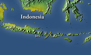
Sumatra is one of the Sunda Islands of western Indonesia. It is the largest island that is entirely governed by Indonesia and the sixth-largest island in the world at 473,481 km2.

The Strait of Malacca or Straits of Malacca is a narrow, 550 mi (890 km) stretch of water between the Malay Peninsula and the Indonesian island of Sumatra. As the main shipping channel between the Indian Ocean and the Pacific Ocean, it is one of the most important shipping lanes in the world. It is named after the Malacca Sultanate that ruled over the archipelago between 1400 and 1511, which is the center of administration is located in the modern-day state of Malacca, Malaysia.

The Sunda Strait is the strait between the Indonesian islands of Java and Sumatra. It connects the Java Sea to the Indian Ocean. The name came from Sunda Kingdom, a kingdom ruling the west part of Java. It also comes from the name of the Sundanese people, the native people of West Java, with the Javanese people being found mostly in Central and East Java.
The Lombok Strait, is a strait connecting the Java Sea to the Indian Ocean, and is located between the islands of Bali and Lombok in Indonesia. The Gili Islands are on the Lombok side.

The Karimata Strait also spelled Carimata or Caramata is the wide strait that connects the South China Sea to the Java Sea, separating the Indonesian islands of Sumatra and Borneo (Kalimantan). It is bordered by the Belitung island in the west and Borneo in the east. It is the widest strait that connects the South China Sea and the Java Sea, but its numerous islands and reefs reduce its navigability. Its weather and current is influenced by the annual southeast and northwest monsoon.
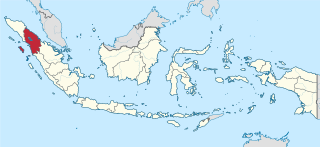
North Sumatra is a province of Indonesia. It consists of a large northwestern belt of the island of Sumatra and its capital is Medan. North Sumatra is the fourth most-populous province after West Java, East Java and Central Java — it covers an area of 72,981 sq.km, and at the Census of 2015 it had a population of 13,923,262; the latest official estimate as at mid 2019 is 14,639,400.

South Sumatra is a province of Indonesia. It is located on the southeast of the island of Sumatra, The province spans 91,592.43 km2 (35,364 sq mi) and an estimated population of 8,497,196. The capital of the province is Palembang. The province borders the provinces of Jambi to the north, Bengkulu to the west and Lampung to the south. The Bangka Strait in the east separates South Sumatra and the island of Bangka, which is part of the Bangka Belitung Islands province. This province is rich in natural resources, such as petroleum, natural gas and coal. The province is inhabited by many different ethnic groups, with the Malays the largest ethnic group. Most speak Palembang Malay, which is mutually unintelligible to both Indonesian and Standard Malay. Other ethnic groups include the Javanese, Sundanese, Minangkabau and Chinese. Most are concentrated in urban areas and are largely immigrants from other parts of Indonesia.
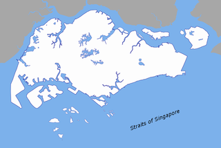
The Singapore Strait is a 105-kilometer long, 16-kilometer wide strait between the Strait of Malacca in the west and the Karimata Strait in the east. Singapore is on the north of the channel and the Riau Islands are on the south. The Indonesia-Singapore border lies along the length of the strait.
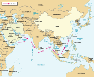
Malaccamax is a naval architecture term for the largest tonnage of ship capable of fitting through the 25-metre-deep (82 ft) Strait of Malacca. Bulk carriers and supertankers have been built to this tonnage, and the term is chosen for very large crude carriers (VLCC). They can transport oil from Arabia to China. A typical Malaccamax tanker can have a maximum length of 333 m (1,093 ft), beam of 60 m (197 ft), draught of 20.5 m (67.3 ft), and tonnage of 300,000 DWT.

Weh Island, often known as Sabang after the largest city, is a small active volcanic island to the northwest of Sumatra, 45 minutes by fast regular ship or 2 hours by ferry from mainland, Banda Aceh. It was originally connected to the Sumatran mainland and became separated by sea after the volcano's last eruption in the Pleistocene era. The island is situated in the Andaman Sea. The largest city on the island, Sabang, is the northernmost outpost of Indonesia.

Rupat is an island in the Strait of Malacca, and forms part of Bengkalis Regency within Riau Province of Indonesia. It lies just off the eastern coast of Sumatra, across from Dumai city, from which it is separated by the Rupat Strait. Its area is 1,490 km². With a population of 43,570 at the 2010 Census, the island is sparsely populated, with a population density of 29¼ per km². Rupat was one of thousands of abandoned islands, but now the population is growing year after year. It makes them expand the area for the settlement.

The September 2007 Sumatra earthquakes were a series of megathrust earthquakes that struck the Sunda Trench off the coast of Sumatra, Indonesia, with three of magnitude 7 or greater. A series of tsunami bulletins was issued for the area. The most powerful of the series had a magnitude of 8.4, which makes it in the top 20 of the largest earthquakes ever recorded on a seismograph.

Malaysia, also known as Malaya or West Malaysia, is the part of Malaysia which lies on the Malay Peninsula and surrounding islands. Its area is 132,265 square kilometres (51,068 sq mi), which is nearly 40% of the total area of the country - or slightly larger than England. It shares a land border with Thailand to the north and Singapore at the southernmost tip.
The Malacca Strait Bridge is a proposed bridge that would connect Telok Gong, near Masjid Tanah, Malacca state in Peninsula Malaysia, Malaysia to Rupat Island and Dumai in Sumatra island, Indonesia. The project has been submitted for government approval, and is expected to take 10 years to complete. Once completed, the 48-kilometre-long (30 mi) bridge will be the longest sea-crossing bridge in the world. The project will have two cable-stayed bridges and one suspension bridge, both the longest in the world.
Brother Island or Brothers Island may refer to any of several islands and island groups around the world, including
The Rukan Islands, also known as the Three Brothers, is a group of three small islands at the south entrance of Durian Strait, in the Riau Islands Province of Indonesia, off the north coast of Sumatra near Singapore. The group extends about 7.2 km north to south, and is surrounded by many dangerous wrecks.
Salahnama Island is a small island in the Strait of Malacca, off the coast of Sumatra, about 40 km from Tanjungbalai and 10 km south of Pandang Island. It belongs to Indonesia.
Little Iyu Island is a small island in the Strait of Malacca, about 4.5 km north-west of Little Karimun Island, about 50 km west of Singapore, and about 800 m north-east of the Great Iyu Island. The two Iyu islets are known as The Brothers.
Great Iyu Island is a small uninhabited island in the Strait of Malacca, about 4.5 km north-west of Little Karimun, about 50 km west of Singapore, and about 800 m south-west of Little Iyu Island. The two Iyu islets are known as The Brothers. The island belongs to the Karimun Regency of the Riau Islands Province of Indonesia.
Little Karimun is an island in the Strait of Malacca, about 58 kilometres (36 mi) west of Batam and 35 km south-west of Singapore. It belongs to the Karimun Regency of the Riau Islands Province of Indonesia. It is located just off the east coast of Sumatra.