
Yosemite Falls is the highest waterfall in Yosemite National Park, dropping a total of 2,425 feet (739 m) from the top of the upper fall to the base of the lower fall. Located in the Sierra Nevada of California, it is a major attraction in the park, especially in late spring when the water flow is at its peak.

Multnomah Falls is a waterfall located on Multnomah Creek in the Columbia River Gorge, east of Troutdale, between Corbett and Dodson, Oregon, United States. The waterfall is accessible from the Historic Columbia River Highway and Interstate 84. Spanning two tiers on basalt cliffs, it is the tallest waterfall in the state of Oregon at 620 ft (189 m) in height. The Multnomah Creek Bridge, built in 1914, crosses below the falls, and is listed on the National Register of Historic Places.

Fall Creek Falls State Resort Park is a state park in Van Buren and Bledsoe counties, in the U.S. state of Tennessee. The over 30,638-acre (123.99 km2) park is centered on the upper Cane Creek Gorge, an area known for its unique geological formations and scenic waterfalls. The park's namesake is the 256-foot (78 m) Fall Creek Falls, the highest free-fall waterfall east of the Mississippi River.
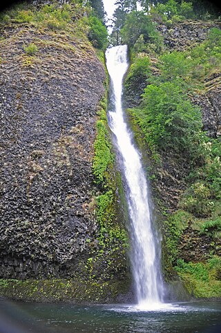
Horsetail Falls is a waterfall located on Horsetail Creek along the Columbia River Gorge in Multnomah County, in the U.S. state of Oregon. The falls drop over a cut over the columnar basalt cliff within the Oneonta Gorge. It is one of the waterfalls along the Columbia River Highway's waterfall corridor.
The Black River is a 41.1-mile-long (66.1 km) river on the Upper Peninsula of the U.S. state of Michigan, flowing mostly in Gogebic County into Lake Superior at 46°40′03″N90°02′57″W. Its source at 46°18′54″N90°01′15″W is a boreal wetland on the border with Iron County, Wisconsin. The northern section of the river, 14 miles (23 km) within the boundaries of the Ottawa National Forest, was designated a National Wild and Scenic River in 1992.

Raven Cliff Falls are located in White County, Georgia on a creek that joins Dodd Creek. The waterfall consists of three drops, a 60-foot (18 m) drop, followed by a 20-foot (6.1 m) drop into a deep pool, followed by a cascade of 20 feet (6.1 m) to Dodd Creek. The waterfall is an unusual double cascade flowing down through a fissure in a massive granite outcrop. There are also three other major waterfalls located on Dodd Creek, with the largest having a 70-foot (21 m) drop.

Crabtree Falls is one of the tallest sets of waterfalls in the United States east of the Mississippi River. It is located in the George Washington National Forest in Nelson County, Virginia, off of Virginia State Route 56. The name of the falls is thought to have come from William Crabtree, who settled in this part of Virginia in 1777. L.A. Snead, former US Assistant Fuel Administrator (WWI), environmentalist and notable Nelsonian, spearheaded negotiations to secure land surrounding Crabtree Falls after it was almost developed as a resort area in the late 1960s. Using personal and Congressional funds, the land deals were completed and the deeds transferred by LA Snead on June 3, 1968, to the National Forest System. This assured benefit for future generations of this magnificent Nelson County treasure.

Linville Falls is a waterfall located in the Blue Ridge Mountains of North Carolina in the United States. The falls move in several distinct steps, beginning in a twin set of upper falls, moving down a small gorge, and culminating in a high-volume 45-foot (14 m) drop.

Scott's Gulf is a canyon situated along the Caney Fork River in White County, Tennessee, in the southeastern United States. The canyon stretches for approximately 18 miles (29 km) as the Caney Fork drops from the top of the Cumberland Plateau down to the eastern Highland Rim. This remote section of the river is home to a wilderness area consisting of a largely undisturbed deciduous forest, numerous waterfalls, caves and other geological formations, and Class IV and Class V whitewater rapids.

Tip Toe Falls, is a 6-foot (1.8 m) tall waterfall on Fall Creek in the Portola Redwoods State Park, California. There is also an 8-foot (2.4 m) upper falls, a few hundred feet upstream, which is much lesser known.
Foss River Falls is a 650-foot (200 m) drop on the West Fork Foss River in the Alpine Lakes Wilderness Area, King County, Washington. Its sources are at Delta Lake, and the 70-foot (21 m)-wide drop flows year-round. The waterfall is split into two parts. Each part is split into several tiers.

Sulphide Creek Falls is a tall, moderately large volume waterfall within North Cascades National Park in Washington state that is one of the tallest waterfalls in North America. The falls drop from Sulphide Lake on the southeast side of Mount Shuksan down a narrow flume-like canyon to a broad basin below. Because of the narrow, twisting shape of the canyon the waterfall is exceptionally difficult to see from ground-level perspectives. The total vertical drop of the waterfall is in the range of 2,100 feet (640 m) to 2,200 feet (670 m) feet, but it has not yet been accurately measured. Foot access to the bottom of the waterfall involves 2.5 miles (4.0 km) of off-trail travel in extremely brushy terrain and several potentially dangerous fords of a large stream.

Eagle Creek is a tributary of the Columbia River in Multnomah and Hood River counties in the U.S. state of Oregon. It cuts through a narrow canyon in its 3,200 feet (980 m) descent to the Columbia River Gorge and is known for its concentration of 13 waterfalls in about 5 miles (8.0 km) distance. Eight major falls are on Eagle Creek and the East Fork Eagle Creek itself, while five are on its tributaries.
Mazama Falls, also referred to more simply as Wells Creek Falls, is a waterfall on Wells Creek in the U.S. state of Washington. At nearly 500 feet (150 m) high, it is said to be the largest waterfall in the Wells Creek watershed.
The valley of the West Fork Foss River contains a fair amount of waterfalls. The river heads in a series of large lakes: Big Heart Lake, Angeline Lake, and Otter Lake- which form spectacular waterfalls as they plunge down to Delta Lake. On the valley walls downstream of Delta Lake, are found even more waterfalls.

Salt Creek Falls is a cascade and plunge waterfall on Salt Creek, a tributary of the Middle Fork Willamette River, that plunges into a gaping canyon in the Willamette National Forest near Willamette Pass in Lane County, Oregon. The waterfall is notable for its main drop of 286 feet (87 m), ranking third highest among plunge waterfalls in Oregon, after Multnomah Falls and Watson Falls.) The pool at the bottom of Salt Creek Falls waterfall is 66 feet (20 m) deep.

There are 24 named waterfalls in Ricketts Glen State Park in the U.S. state of Pennsylvania along Kitchen Creek as it flows in three steep, narrow valleys, or glens. They range in height from 9 feet (2.7 m) to the 94-foot (29 m) Ganoga Falls. Ricketts Glen State Park is named for R. Bruce Ricketts, a colonel in the American Civil War who owned over 80,000 acres in the area in the late 19th and early 20th centuries, but spared the old-growth forests in the glens from clearcutting. The park, which opened in 1944, is administered by the Bureau of State Parks of the Pennsylvania Department of Conservation and Natural Resources (DCNR). Nearly all of the waterfalls are visible from the Falls Trail, which Ricketts had built from 1889 to 1893 and which the state park rebuilt in the 1940s and late 1990s. The Falls Trail has been called "the most magnificent hike in the state" and one of "the top hikes in the East".
Swampy Creek Falls is a scenic, two-tiered horsetail waterfall along an unnamed tributary of the White Salmon River, originating from Swampy Meadows, on Mount Adams west slope, with a total height of 52 ft (16 m). Its main drop is about 30 ft (9 m) feet. It cascades down over an exposure of andesite, then veiling out over sloped ledges below, among a secluded forest. The falls are located not more than 800 feet from Forest Route 23, and is noted for having a secluded nature, seeming as if nothing is around for miles. It can be accessed while heading to the Midway High Lakes Area and Takhlakh Lake from Trout Lake or the Lewis River. From the road, viewers have to follow the Pacific Crest Trail for a few hundred feet, then crossing an unnamed stream on a footbridge. From here, hikers must follow the creek downstream to the top of the falls, then descending down to its base. The falls is managed by the Gifford Pinchot National Forest, of Washington state.

