
Krishna district is a district in the coastal Andhra Region in Indian state of Andhra Pradesh, with Machilipatnam as its administrative headquarters. It is surrounded on the East by Bay of Bengal, West by Guntur, Bapatla and North by Eluru and NTR districts and South again by Bay of Bengal.

East Godavari is a district in the Coastal Andhra region of Andhra Pradesh, India. Its district headquarters is at Rajamahendravaram.

Rajahmundry, officially Rajamahendravaram, is a city in the Indian state of Andhra Pradesh and district headquarters of East Godavari district. It is the seventh most populated city in the state. During British rule, the district of Rajahmundry was created in the Madras Presidency in 1823. It was reorganised in 1859 and bifurcated into the Godavari and Krishna districts. Rajahmundry was the headquarters of Godavari district, which was further bifurcated into East Godavari and West Godavari districts in 1925. It is administered under Rajahmundry revenue division of the East Godavari district. The city is known for its floriculture, history, culture, agriculture, economy, tourism, and its heritage. It is known as the "Cultural Capital of Andhra Pradesh".
Kattangoor is a village in Nalgonda district of state of Telangana, India. It is located in Kattangur, mandal of the Nalgonda division.

Kurnool district is one of the eight districts in the Rayalaseema region of the Indian state of Andhra Pradesh after the districts are reorganised in April 2022. It is located in the north western part of the state and is bounded by Nandyal district in the east, Anantapur district in the south, Raichur district of Karnataka in the northwest, Bellary district of Karnataka in the west, and Jogulamba Gadwal district of Telangana in the north. It has a population of 2,271,686 based on the 2011 census. The city of Kurnool is the headquarters of the district.

Nellore district, officially known as Sri Potti Sriramulu Nellore district in Coastal Andhra Region, is one of the 26 districts in the Indian state of Andhra Pradesh. According to the 2011 Census, the district's population was 2,469,712 of which 29.07% was urban. Its administrative headquarters are located in Nellore city. Located in the Coastal Andhra region, the district is bordered by the Bay of Bengal to the east, Kadapa district and Annamayya district to the west, Prakasam district to the north, and Tirupati district to the south.

Prakasamdistrict is one of the twelve districts in the coastal Andhra region of the Indian state of Andhra Pradesh. It was formed in 1970 and reorganised on 4 April 2022. The headquarters of the district is Ongole. It is located on the western shore of Bay of Bengal and is bounded by Bapatla district and Palnadu districts in the north, Nandyal district in the west, Kadapa and Nellore districts in the south. A part of north west region also borders with Nagarkurnool district of Telangana. It is the largest district in the state with an area of 14,322 km2 (5,530 sq mi) and had a population of 22,88,026 as per 2011 Census of India.
Nandyal is a city and District headquarters of Nandyal district of the Indian state of Andhra Pradesh. It is a municipality and the headquarters of Nandyal mandal in Nandyal revenue division.
Velama is an upper caste found mainly in Telangana and Andhra Pradesh. The earliest occurrence of Velama as a term for a community dates from the 17th century. In caste based hierarchy they hold the highest position along with Reddy and Kamma castes. In Telangana they are called "Dora" by other lower castes, a term that implies a high level of respect.
Kapu is a Hindu caste mainly found in the Indian state of Andhra Pradesh. They are classified as a Forward caste. They are a community of land-owning agriculturists. Historically, they have also been warriors and military generals (Nayakas) in Hindu armies. They are a dominant caste of Andhra Pradesh. Kapus commonly carry the title Naidu. They are primarily present in Coastal Andhra with major concentration in the Godavari-Krishna delta region.
The Balija are a Telugu-speaking mercantile community primarily living in the Indian states of Andhra Pradesh, Tamil Nadu, Karnataka and in smaller numbers in Telangana and Kerala.
Telaga is a community found in Coastal Andhra region of India. Telaga is a subcaste of Kapu and both terms are often used synonymously. They are classified as a Forward caste. They are a land-owning agrarian community. Historically, they were a warrior caste known for their honour and bravery.
Chebrolu is a village in Guntur district of the Indian state of Andhra Pradesh. It is the headquarters of Chebrolu mandal in Tenali revenue division. It was once a Buddhist site and territorial capital of Kakatiya dynasty. The Archaeological excavations revealed Buddhist artefacts of Satavahana and Ikshavaku period.

The recorded history of Andhra Pradesh, one of the 28 states of 21st-century India, begins in the Vedic period. It is mentioned in Sanskrit epics such as the Aitareya Brahmana. Its sixth-century BCE incarnation Assaka lay between the Godavari and Krishna Rivers, one of sixteen mahajanapadas. The Satavahanas succeeded them, built Amaravati, and reached a zenith under Gautamiputra Satakarni.

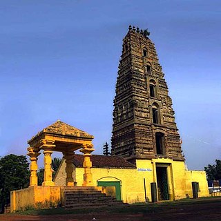
Allagadda is a town in Nandyal district of the Indian state of Andhra Pradesh. It is located in Nandyal Revenue division. The town is located at 15°08′00″N78°31′00″E.

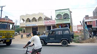
Koilakuntla is a town in Nandyal district of the Indian state of Andhra Pradesh. It is Head quarter of Koilakuntla mandal. in Dhone revenue division
Shermuhammadpuram is a village located in Etcherla mandal in Srikakulam district, northeastern Andhra Pradesh, India. It is located 7 miles (11 km) east of Chipurupalle, and 4 miles (6.4 km) west of Srikakulam (Chicacole). It contains the ruins of a palace built by a Mussulman governor who gave his name to the place. A 1922 publication stated that "there was a general failure of crops in Madugula and of wet crops in Shermuhammadpuram".

Banganapalle mangoes is a mango variety produced in Banganapalle of Nandyal District in the Indian state of Andhra Pradesh.It's also state fruit of Andhra. It alone occupies 70% percent of total mango cultivable area of the state and was first introduced by the farmers of Banaganapalli. It was registered as one of the geographical indication from Andhra Pradesh on 3 May 2017, under horticultural products by Geographical Indication Registry. It is also grown in the other parts of India and Pakistan. The fruit is described as obliquely oval in shape, around 20cm in length, with yellow flesh and a thin, smooth yellow skin. The flesh is of a firm, meaty texture and is sweet and lacks fibre. The cultivar is the most sought after in Andhra Pradesh. It is a very late-season variety that is good for canning. This cultivar is a source of vitamin A & C and is also called king of Mangoes.
Nandikotkur is a Scheduled Caste reserved constituency in Nandyal district of Andhra Pradesh that elects representatives to the Andhra Pradesh Legislative Assembly in India It is one of the seven assembly segments of the Nandyal Lok Sabha constituency.

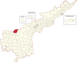
Nandyal district is a district in the Indian state of Andhra Pradesh with Nandyal as its administrative headquarters, it was formed on 4 April 2022 to become one of the resultant 26 districts. It is part of the Rayalaseema region. The district consists of Nandyal revenue division and a newly formed Dhone revenue division and Atmakur revenue division from Kurnool district.

