Panyimur

Last updated

Panyimur
Uganda location map.svg
Red pog.svg
Panyimur
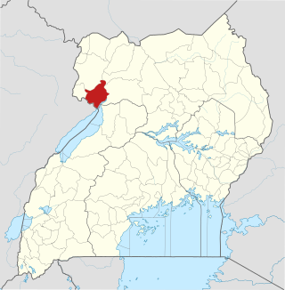
Location in Uganda
Coordinates: 02°17′43″N31°20′46″E / 2.29528°N 31.34611°E / 2.29528; 31.34611
Country Uganda
Region Northern Region of Uganda
Sub-region West Nile sub-region
District Pakwach District
Government
   Mayor Peters Openjtho
Elevation
2,028 ft (618 m)

Panyimur is a town in the Pakwach District of the Northern Region of Uganda. Panyimur may also refer to Panyimur sub-county, one of the five administrative subdivisions that constitute Pakwach District. [1]

Contents

Location

Panyimur is located in the West Nile sub-region, along the northwestern shores of Lake Albert (Africa). This is about 28 kilometres (17 mi) south-west of Pakwach, the location of the district headquarters. [2] This is approximately 128 kilometres (80 mi), by road, south-east of Arua, the largest city in the West Nile sub-region. [3]

Population

During the August 2014 national population census, the population of Panyimur sub-county was enumerated at 43,366 inhabitants, of whom 21,111 (48.7 percent) were male and 22,255 (51.3 percent) were female. This was when the subcounty and the rest of Pakwach District were still part of Nebbi District. [4]

Overview

Before 2017, Pakwach District was part of Nebbi District. In that year, Jonam County was curved off to form the new district with five sub-counties and one town council; Pakwach Town Council. [5]

A government-operated ferry connects the lakeside town of Wanseko, in Buliisa District on the eastern shores of Lake Albert to Panyimur, in Pakwach District, on the western shores of the same lake. This cross-lake link allows for passage of people and goods between the Western and the Northern Regions of Uganda, parts of South Sudan and the northeastern parts of the Democratic Republic of the Congo. Goods that are exchanged include wood and fish from Buliisa District. [6]

Panyimur is the location of Panyimur Fish Market, built between 2013 and 2019 at a cost of Ush 1.4 billion (approx. US$380,000), with financial assistance from the embassy of Iceland to Uganda. The fish market is prone to flooding, as happened in 2020. [7]

The Panyimur Hot Springs, also known locally as the Amoropii Hot Springs are a natural hot springs site, located about 3 kilometres (2 mi), outside Panyimur Town. [8] [9]

See also

Related Research Articles

<span class="mw-page-title-main">Nebbi District</span> District in Northern Uganda, Uganda

Nebbi District is a district in Northern Uganda. It is named after its main municipal, commercial and administrative centre, Nebbi, the location of the district headquarters.

<span class="mw-page-title-main">Arua</span> Place in Northern Region, Uganda

Arua is a city and commercial centre within the Arua District in the Northern Region of Uganda.

<span class="mw-page-title-main">West Nile sub-region</span>

West Nile sub-region, previously known as West Nile Province and West Nile District, is a sub-region in north-western Uganda, in the Northern Region of Uganda.
<span class="mw-page-title-main">Adjumani</span> Ugandan town

Adjumani is a town in the Northern Region of Uganda. It is the main municipal, administrative, and commercial centre of Adjumani District. The district is named after the town.

<span class="mw-page-title-main">Pakwach</span> Place in Northern Region of Uganda, Uganda

Pakwach is a town in the Northern Region of Uganda. It is the main commercial, political and administrative center of Pakwach District. In the 19th century the town came under brief occupation by the Ottoman branch of the Khedivate of Egypt, as part of Hatt-ı Üstuva (Equatoria) Vilayet.

Nebbi is a town in the Nebbi District of the Northern Region of Uganda. It is the site of the district headquarters.

<span class="mw-page-title-main">Stanbic Bank Uganda Limited</span> Commercial bank in Uganda

Stanbic Bank Uganda Limited (SBU) is a commercial bank in Uganda and is licensed by the Bank of Uganda, the central bank and national banking regulator.

<span class="mw-page-title-main">Buliisa District</span> Ugandan administrative district

Buliisa District is a district in Western Uganda. As with most Ugandan districts, Buliisa District is named after its "main town" Buliisa, where the district headquarters are located. Bugungu has 6 sub counties: Kigwera, Ngwedo, Buliisa, Butiaba, Kihungya, and Biiso. It also contain 3 town councils: Buliisa, Butiaba and Biiso.

Buliisa, also Bulisa, is a town in the Western Region of Uganda. It is the site of the headquarters of the Buliisa District. Neighborhoods within Buliisa Municipality include Wanseko and Kasenyi.

Muni University (MU) is a public multi-campus university in Uganda. It is one of the public universities and degree-awarding institutions in the country, licensed and supervised by the Uganda National Council for Higher Education (UNCHE).

Hoima–Butiaba–Wanseko Road is a road in the Western Region of Uganda, connecting the city of Hoima and the towns of Butiaba, Buliisa, and Wanseko on the shores of Lake Albert. This is one of Uganda's critical oil roads because it facilitates oil exploration in the Albertine Graben, as well as tourism, due to its proximity to Kabalega National Park.

Wanseko, is a settlement in Western Uganda.

Karuma is a settlement in the Western Region of Uganda.

The Karuma–Olwiyo–Pakwach–Nebbi–Arua Road is a road in the Northern Region of Uganda, connecting the towns of Karuma, Olwiyo, Pakwach, Nebbi and the city of Arua.

Nebbi General Hospital, also Nebbi Hospital, is a hospital in the Northern Region of Uganda.

Parombo is a town in the West Nile sub-region of the Northern Region of Uganda.

<span class="mw-page-title-main">Pakwach District</span> District in Northern Region, Uganda

Pakwach District is a district in the Northern Region of Uganda. The town of Pakwach is the location of the district headquarters.

The Lira–Gulu–Nebbi–Arua High Voltage Power Line is a high voltage electricity power line, under construction in Uganda. It connects the high voltage substation at Lira, in Lira District, to another high voltage substation at Arua, in Arua District, all in the Northern Region of the country.

The Kampala–Gulu Highway, also Kampala–Gulu Road, is a road connecting Uganda's capital city of Kampala, in the Central Region, with the city of Gulu, the largest urban centre in the country's Northern Region.

References

  1. PITW (29 July 2024). "Panyimur is a human settlement in the Northern Region of Uganda". Places In The World (PITW). Retrieved 29 July 2024.
  2. Google (29 July 2024). "Road Distance Between Pakwach, Uganda And Panyimur, Uganda" (Map). Google Maps . Google. Retrieved 29 July 2024.
  3. Google (29 July 2024). "Road Distance Between Arua City, Uganda And Panyimur, Uganda" (Map). Google Maps . Google. Retrieved 29 July 2024.
  4. UBOS (March 2018). "Uganda's Population By Parish: National Census 2014: Northern Region, Uganda" (PDF). Uganda Bureau of Statistics (UBOS). Kampala, Uganda. Retrieved 29 July 2024.
  5. The Citizen Report (29 July 2024). "About Pakwach District". The Citizen Report Uganda. Kampala, Uganda. Retrieved 29 July 2024.
  6. Emmanuel Okello (10 January 2022). "Resumption of Wanseko-Panyimur Ferry Boosts Business". Uganda Radio Network . Kampala, Uganda. Retrieved 29 July 2024.
  7. Patrick Okaba (1 December 2020). "Lake Albert floods submerge Shs 1bn modern fish market in Panyimur". The Cooperator. Kampala, Uganda. Retrieved 29 July 2024.
  8. UST (July 2024). "Amoropii Hot Springs In Northern Uganda". Uganda Safaris Tours (UST). Kampala, Uganda. Retrieved 29 July 2024.
  9. Daily Monitor (4 October 2013). "Panyimur Hot Springs; A Forgotten Treasure". Daily Monitor . Kampala, Uganda. Retrieved 29 July 2024.