Parazinho

Last updated
Parazinho
Municipality
Parazinho - State of Rio Grande do Norte, Brazil - panoramio.jpg
Parazinho and its beach and the surrounding mountains
Bandeira de Parazinho (RN).png
Brasao de Parazinho (RN).png
RioGrandedoNorte Municip Parazinho.svg
Location of Parazinho
CountryFlag of Brazil.svg  Brazil
Region Nordeste
State Rio Grande do Norte
MesoregionAgreste Potiguar
Population
 (2020 [1] )
  Total5,272
Time zone UTC−3 (BRT)

Parazinho is a municipality in the state of Rio Grande do Norte in the Northeast region of Brazil. [2] [3] [4] [5]

Its seal has a ground of a countryside with a tree, on top is a blue star, surrounding are two different type of palm trees founded in the area, on the bottom is the municipality name in a green ribbon with yellow letters. Its flag colors are green, white and blue with the seal in the middle.

See also

Related Research Articles

Brejinho is a municipality in the state of Rio Grande do Norte in the Northeast region of Brazil.

Lagoa d'Anta is a municipality in the state of Rio Grande do Norte in the Northeast region of Brazil.

Santa Maria, Rio Grande do Norte Municipality in Nordeste, Brazil

Santa Maria is a municipality in the state of Rio Grande do Norte in the Northeast region of Brazil.

São Pedro, Rio Grande do Norte Municipality in Nordeste, Brazil

São Pedro is a municipality in the state of Rio Grande do Norte in the Northeast region of Brazil.

Senador Elói de Souza is a municipality in the state of Rio Grande do Norte in the Northeast region of Brazil.

Serrinha is a municipality in the state of Rio Grande do Norte in the Northeast region of Brazil.

Jundiá is a municipality in the state of Rio Grande do Norte in the Northeast region of Brazil.

Ruy Barbosa is a municipality in the state of Rio Grande do Norte in the Northeast region of Brazil.

Serra de São Bento Municipality in Nordeste, Brazil

Serra de São Bento is a municipality in the state of Rio Grande do Norte in the Northeast region of Brazil.

Sítio Novo, Rio Grande do Norte Municipality in Nordeste, Brazil

Sítio Novo is a municipality in the state of Rio Grande do Norte in the Northeast region of Brazil.

Tangará is a municipality in the state of Rio Grande do Norte in the Northeast region of Brazil.

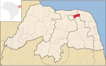
Pedra Grande is a municipality in the state of Rio Grande do Norte in the Northeast region of Brazil.

Pureza, Rio Grande do Norte Municipality in Nordeste, Brazil

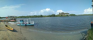
Pureza is a municipality in the state of Rio Grande do Norte in the Northeast region of Brazil. The place means "pure" in Portuguese hence its pure lake located in the area, and it is depicted in the municipal seal.

Arês, Rio Grande do Norte Municipality in Nordeste, Brazil

Arês is a municipality in the state of Rio Grande do Norte in the Northeast region of Brazil.

Espírito Santo is a municipality in the state of Rio Grande do Norte in the Northeast region of Brazil.

Montanhas Municipality in Nordeste, Brazil

Montanhas is a municipality in the state of Rio Grande do Norte in the Northeast region of Brazil.

Senador Georgino Avelino Municipality in Nordeste, Brazil

Senador Georgino Avelino is a municipality in the state of Rio Grande do Norte in the Northeast region of Brazil.

Vila Flor is a municipality in the state of Rio Grande do Norte in the Northeast region of Brazil.

São Gonçalo do Amarante, Rio Grande do Norte The Municipality of São Gonçalo do Amarante in Nordeste, Brazil

São Gonçalo do Amarante is a municipality in the state of Rio Grande do Norte in the Northeast region of Brazil.

São José de Mipibu Municipality in Nordeste, Brazil

São José de Mipibu is a municipality in the state of Rio Grande do Norte in the Northeast region of Brazil.

References

  1. IBGE 2020
  2. "Divisão Territorial do Brasil" (in Portuguese). Divisão Territorial do Brasil e Limites Territoriais, Instituto Brasileiro de Geografia e Estatística (IBGE). July 1, 2008. Retrieved December 17, 2009.
  3. "Estimativas da população para 1º de julho de 2009" (PDF) (in Portuguese). Estimativas de População, Instituto Brasileiro de Geografia e Estatística (IBGE). August 14, 2009. Retrieved December 17, 2009.
  4. "Ranking decrescente do IDH-M dos municípios do Brasil" (in Portuguese). Atlas do Desenvolvimento Humano, Programa das Nações Unidas para o Desenvolvimento (PNUD). 2000. Archived from the original on October 3, 2009. Retrieved December 17, 2009.
  5. "Produto Interno Bruto dos Municípios 2002-2005" (PDF) (in Portuguese). Instituto Brasileiro de Geografia e Estatística (IBGE). December 19, 2007. Retrieved December 17, 2009.

Coordinates: 5°13′22″S35°50′16″W / 5.22278°S 35.8378°W / -5.22278; -35.8378