Parish of Monkellan

Last updated

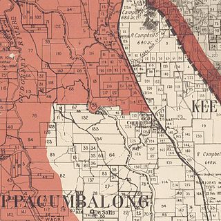
Monkellan Parish is a civil parish of Murray County, New South Wales. [1] [2]

Lands administrative divisions of Australia

Lands administrative divisions of Australia are the cadastral divisions of Australia for the purposes of identification of land to ensure security of land ownership. Most states term these divisions as counties, parishes, hundreds, and other terms. The eastern states of Queensland, New South Wales, Victoria and Tasmania were divided into counties and parishes in the 19th century, although the Tasmanian counties were renamed land districts in the 20th century. Parts of South Australia (south-east) and Western Australia (south-west) were similarly divided into counties, and there were also five counties in a small part of the Northern Territory. However South Australia has subdivisions of hundreds instead of parishes, along with the Northern Territory, which was part of South Australia when the hundreds were proclaimed. There were also formerly hundreds in Tasmania. There have been at least 600 counties, 544 hundreds and at least 15,692 parishes in Australia, but there are none of these units for most of the sparsely inhabited central and western parts of the country.

Murray County, New South Wales Cadastral in New South Wales, Australia

Murray County was one of the original Nineteen Counties in New South Wales and is now one of the 141 Lands administrative divisions of New South Wales. It included the area which is now part of Canberra and as far north as Lake George and Yass. It was originally bounded on the west by the Murrumbidgee River, on the east by the Shoalhaven River and on the north by the Yass River. A large area of the county was transferred to the Commonwealth government in 1909 in the Seat of Government Acceptance Act to make part of the Australian Capital Territory, along with land in Cowley County. Since then, the ACT border is now part of the western boundary. Part of the ACT border is determined by property boundaries in the Parish of Keewong, in the County of Murray; specifically the southern end of portions 177, 218, 211, 36, and 38. This is mentioned in the Seat of Government Acceptance Act of 1909.

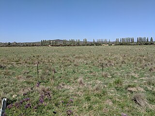
Monkellan is located at 35°39′54″S149°12′04″E / 35.66500°S 149.20111°E / -35.66500; 149.20111 Coordinates: 35°39′54″S149°12′04″E / 35.66500°S 149.20111°E / -35.66500; 149.20111 and is on the Monaro Highway just outside the Australian Capital Territory. Its western border is formed by the Murrumbidgee River and its southern border by Michelago creek. It includes most of Michelago.

Geographic coordinate system Coordinate system

A geographic coordinate system is a coordinate system that enables every location on Earth to be specified by a set of numbers, letters or symbols. The coordinates are often chosen such that one of the numbers represents a vertical position and two or three of the numbers represent a horizontal position; alternatively, a geographic position may be expressed in a combined three-dimensional Cartesian vector. A common choice of coordinates is latitude, longitude and elevation. To specify a location on a plane requires a map projection.

Monaro Highway highway linking Victoria and the Australian Capital Territory

The Monaro Highway is a highway that is located in Victoria, New South Wales and the Australian Capital Territory, in Australia.

Australian Capital Territory Federal territory of Australia, containing the capital city, Canberra

The Australian Capital Territory, formerly known as the Federal Capital Territory until 1938 and commonly referred to as the ACT, is a federal territory of Australia containing the Australian capital city of Canberra and some surrounding townships. It is located in the south-east of the country and is an enclave within the state of New South Wales. Founded after federation as the seat of government for the new nation, all important institutions of the Australian federal government are centred in the Territory.

Related Research Articles

Parish of Tuggeranong Cadastral in New South Wales, Australia

Tuggeranong Parish is a parish of Murray County, New South Wales, a cadastral unit for use on land titles. It is now about a third of the size it was in the nineteenth century, after most of the land in the parish was transferred to the Australian Capital Territory in 1911. It currently includes a small section of land in New South Wales between the ACT border and Jerrabomberra Creek, but once included most of what is now the Canberra town centre of Tuggeranong.

Parish of Queanbeyan Cadastral in New South Wales, Australia

Queanbeyan Parish is a parish of Murray County, New South Wales, a cadastral unit for use on land titles. It covers the city of Queanbeyan. It was originally bounded by the Molonglo River to the north, but is now bounded by the NSW-ACT border in the north and west. Parts of the western area of the parish were transferred to the Australian Capital Territory in 1909, including what are now the Canberra suburbs of Fyshwick, Narrabundah, Kingston, Oaks Estate, Harman and part of Hume.

Parish of Keewong Cadastral in New South Wales, Australia

Keewong Parish is a parish of Murray County, New South Wales, a cadastral unit for use on land titles. A small part of the north-western end of the parish around 35°34′40″S149°07′28″E between the Murrumbidgee River and the Queanbeyan-Cooma railway line was transferred to the Australian Capital Territory in 1909. The southern ends of portions 177, 218, 211, 36, and 38 in the Parish of Keewong form part of the border of the ACT with New South Wales, which is mentioned in the Seat of Government Acceptance Act of 1909.

Mann River, a perennial stream of the Clarence River catchment, is located in the Northern Rivers district of New South Wales, Australia.

Bulgandramine is a rural cadastral parish in Narromine County, NSW, approximately 370 km north west from Sydney, west of Trangie. It is within the Narromine Council area at 32°37′54″S 148°12′04″E. Bulganramine is 239 m above sea level.

Yarrangobilly, New South Wales is a rural locality in the Snowy Mountains, west of Canberra, Australia, and is also a civil Parish of Buccleuch County.

Biala, New South Wales is a civil parish of King County, New South Wales.

Nelanglo Parish is a civil parish of King County, New South Wales.

Rabnor Parish is a civil parish of King County, New South Wales. ).

Romner Parish is a civil parish of King County, New South Wales.

Winduella Parish is a civil parish of King County, New South Wales.

Ellenden Parish, is a civil parish of Murray County, New South Wales.

Currandooly Parish is a civil parish of Murray County, New South Wales.

Ballallaba Parish is a civil parish of Murray County, New South Wales.

Parish of Larbert

Larbert Parish is a civil parish of Murray County, New South Wales.

Parish of Molonglo

Molonglo Parish, New South Wales is a civil parish of Murray County.

Jinglemoney Parish is a civil parish of Murray County, New South Wales. It is located around Bombay on Bombay Creek, a tributary of the Shoalhaven River in the Queanbeyan–Palerang Regional Council.

Bramina is a rural locality of the Snowy Mountains and a civil parish of Buccleuch County, New South Wales.

Napier Parish, New South Wales

Napier is a rural locality of Warrumbungle Shire Council and a civil parish of Napier County New South Wales. and is at 31°35′54″S149°46′04″E.

References

  1. Robert McLean, The New atlas of Australia : the complete work containing over one hundred maps and full descriptive geography of New South Wales, Victoria, Queensland, South Australia and Western Australia, together with numerous illustrations and copious indices (Sydney :J. Sands, [1886) Map 11.
  2. "Monkellan Parish". Geographical Names Register (GNR) of NSW. Geographical Names Board of New South Wales . Retrieved 17 April 2018. OOjs UI icon edit-ltr-progressive.svg