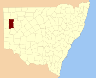
Nantomoko is a remote civil parish of Poole County in far northwest New South Wales. [1] [2] located at 29°12′51″S141°04′50″E / 29.2143°S 141.0805°E

Nantomoko is a remote civil parish of Poole County in far northwest New South Wales. [1] [2] located at 29°12′51″S141°04′50″E / 29.2143°S 141.0805°E
The geography of the parish is mostly the flat, arid landscape of the Channel Country. The parish has a Köppen climate classification of BWh (hot desert). [3] The county is barely inhabited with a population density of less than 1 person per 150 km2 and the landscape is a flat arid scrubland.
The nearest town is Tibooburra to the east, which is on the Silver City Highway and the parish lies south of the Sturt National Park. [4] There is also a small settlement at Cameron's Corner just over the Queensland Border.
The parish is on the traditional lands of the Wadigali [5] and to some extent Karenggapa, [6] Aboriginal peoples. [7]
Charles Sturt passed through the parish during 1845, [8] and In 1861 the Burke and Will's expedition passed to the east, [9] through what is now the Pindera Aboriginal Area. [10]
Gold was discovered nearby in the 1870s, and the miners were followed by pastoral farming enterprises.

Fort Grey is a remote civil parish of Poole County in far North West New South Wales. located at 29.1731°S 141.0307°E.

Pinaroo is a remote civil parish of Poole County in far north west New South Wales, located at 29°08′04″S 141°06′55″E.

Sturt Parish is a remote civil parish of Poole County in far North West New South Wales, located at 29.433056°S 141.519722°E.
Wirratcha Parish is a remote rural locality and civil parish of Evelyn County in far northwest New South Wales. located at 29°38′31″S 142°01′00″E.

Mount Blackwood, New South Wales located at 29°48′37″S 141°31′10″E, is a remote rural locality and civil parish of Evelyn County in far northwest New South Wales. located at 30°04′42″S 142°45′50″E, east of the Silver City Highway . The geography of the parish is mostly the flat, arid landscape of the Channel Country. The parish has a Köppen climate classification of BWh.

Milring Parish is a remote rural locality and civil parish of Evelyn County in far northwest New South Wales. located at 29°54′29″S 141°40′53″E.
Coally is a remote rural locality and civil parish of Evelyn County, New South Wales in far northwest New South Wales located at 29°51′00″S 141°50′39″E.
Whitty is a remote rural locality and civil parish of Evelyn County in far northwest New South Wales. located at 30°12′34″S 141°05′06″E.
Mouloonk is a remote rural locality and civil parish of Evelyn County in far northwest New South Wales. located at 30°09′04″S 141°07′08″E.

Haynes is a remote civil parish of Evelyn County in far northwest New South Wales, located at 30°24′24″S 141°04′48″E.
Quintyambi is a remote rural locality and civil parish of Evelyn County in far northwest New South Wales. located at 30°18′40″S 141°05′05″E.
Bimpia located at 30°47′21″S 142°03′46E is a remote civil parish of Mootwingee County in far North West New South Wales.

Booraboonara located at 31°25′02″S 141°44′53″E is a remote civil parish of Mootwingee County in far North West New South Wales.
Boorla located at 30.968333°S 141.859167°E is a remote civil parish of Mootwingee County in far North West New South Wales.

The Parish of Essie, New South Wales is a remote civil parish of Evelyn County, New South Wales in far northwest New South Wales, located at 29.839722°S 141.134722°E, on the border with South Australia.

Parish of Paradise, New South Wales is a remote civil parish of Evelyn County, New South Wales in far northwest New South Wales. located at 29.850000°S 141.844167°E on the border with South Australia.
Scott Parish, New South Wales is a remote rural locality and civil parish of Evelyn County, New South Wales in far northwest New South Wales. located at 29°38′31″S 142°01′00″E.
The Parish of Blackwood is a remote civil parish of Poole County in far North West New South Wales,
Wonominta, New South Wales is a remote rural locality and civil parish of Evelyn County in far northwest New South Wales. located at 30°18′40″S 141°05′05″E.
Parish of Kooltoo, New South Wales is a remote civil parish of Yantara County in far North West New South Wales. The geography of the parish is mostly the flat, arid landscape of the Channel Country. The parish has a Köppen climate classification of BWh.