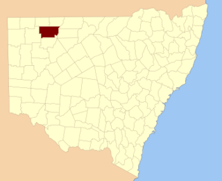
Ularara County is one of the 141 Cadastral divisions of New South Wales. It is located to the west of the Paroo River.

Allundy, New South Wales, located at 29°53′05″S 143°34′02″E, is a parish of Ularara County in north west New South Wales, Australia.
Indi, New South Wales, located at 29°48'45.0"S 143°24'00.0"E is a Parish of Ularara County in north west New South Wales. It is between Milparinka, New South Wales and Wilcannia.
Dundaga is a Parish of Ularara County in north west New South Wales, Australia. It is between Milparinka, New South Wales and Wilcannia and west of Wanaaring. The main economic activity of the parish is agriculture, with the Ardoo and the Salisbury Downs Station. the parish is at 29°57′35″S 143°24′02″E.
Deriringa is a Parish of Ularara County in north west New South Wales. It is between Milparinka, New South Wales and Wilcannia and west of Wanaaring. The main economic activity of the parish is agriculture, with the Ardoo and the Salisbury Downs Station. the parish is at 30°06′37″
Buntiara is a Parish of Ularara County in north west New South Wales. It is between Milparinka, New South Wales and Wilcannia and west of Wanaaring.
Yambunya is a Parish of Ularara County in north west New South Wales. It is between Milparinka, New South Wales and Wilcannia and west of Wanaaring.
Narumerpy, New South Wales is a Parish of Ularara County in north west New South Wales. It is between Milparinka, New South Wales and Wilcannia and west of Wanaaring.
Kootooloomondoo, New South Wales, located at 30.078611°S 142.956111°E is a Parish of Yantara County in north west New South Wales. It is between Milparinka, New South Wales and Wilcannia The main economic activity of the parish is agriculture, the Salisbury Downs Station is nearby.
.Yailah, New South Wales is a Parish of Ularara County in north west New South Wales. It is at 29°36′44″S 143°45′01″E between Milparinka, New South Wales and Wilcannia and west of Wanaaring. The main economic activity of the prish is agriculture.
Yipunyah Parish is a Parish of Ularara County in north west New South Wales. It is at 29°58′47″S 143°59′38″E between Milparinka, New South Wales and Wilcannia and west of Wanaaring.
Croombimbie is a Parish of Ularara County in north west New South Wales.
Hebden is a Parish of Ularara County in north west New South Wales.

Momba located at 30.035556°S 144.050833°E is a cadastral parish of Ularara County New South Wales.
Urilla Parish located at 29.655278°S 143.068611°E is a cadastral parish of Ularara County New South Wales.
Parish of Urisino, New South Wales located at 29.690833°S 143.750833°E is a cadastral parish of Ularara County New South Wales.
Parish of Waoona, New South Wales located at 29.738889°S 143.234722°E is a cadastral parish of Ularara County New South Wales.
Parish of Warruera, New South Wales Located at 29.624722°S 144.178611°E, six Kilometers north of Wanaaring, New South Wales is a cadastral parish of Ularara County New South Wales.
Neon Parish, New South Wales is a rural locality and a cadastral parish of Ularara County New South Wales.
Peka, New South Wales located at 29°53'04.0"S 143°58'36.0"E is an uninhabited cadastral parish of Ularara County in north western New South Wales.
