
Caringbah is a suburb in southern Sydney, in the state of New South Wales, Australia. Caringbah is 24 kilometres (15 mi) south of the Sydney central business district in the local government area of Sutherland Shire.

Sutherland is a suburb in southern Sydney, in the state of New South Wales, Australia. Sutherland is located 30 kilometres south of the Sydney central business district and is the administrative centre for the local government area of the Sutherland Shire.

St George Area refers to an old County Council formed by the local councils of several southern suburbs in Sydney, in the state of New South Wales, Australia. The area includes all the suburbs in the local government area of Georges River Council and the part of Bayside Council which was Rockdale City prior to 2016. The eastern boundary of the district is Lady Robinson Beach on Botany Bay.

Oyster Bay is a suburb in Southern Sydney, in the state of New South Wales, Australia. It is located 26 kilometres south of the Sydney central business district in the local government area of the Sutherland Shire.
Kurnell is a suburb in Sydney, in the state of New South Wales, Australia. It is 21.4 kilometres (13.3 mi) south of the Sydney central business district, in the local government area of the Sutherland Shire along the east coast. Cronulla and Woolooware are the only adjacent suburbs. La Perouse is located opposite, on the northern headland of Botany Bay. The Cronulla sand dunes are on the south eastern headland of Botany Bay. The eastern side of the peninsula is part of Botany Bay National Park, and Towra Point Nature Reserve is located on the western side of the suburb.
Kangaroo Point is a tiny suburb in southern Sydney, in the state of New South Wales, Australia. It is 22 kilometres south of the Sydney central business district in the local government area of the Sutherland Shire.

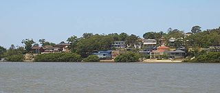
Bonnet Bay is a suburb in southern Sydney, in the state of New South Wales, Australia that is located 29 kilometres (18 mi) south of the Sydney central business district in the local government area of the Sutherland Shire. Its postcode is 2226, which it shares with neighbouring Jannali and Como. Bonnet Bay is located on the eastern bank of the Woronora River, which flows north into the Georges River.
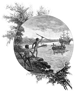
Forby Sutherland was a member of the crew of the Endeavour during Lieutenant Cook's voyage to New South Wales. He died while the ship was in Botany Bay, making him the first British subject to die in Australia and the first European to die in New South Wales.
Field of Mars Parish is one of the 57 parishes of Cumberland County, New South Wales, a cadastral unit for use on land titles. While the name is mostly forgotten as a region name today, it has given the name to the modern suburb of Marsfield and the reserve in the area. It is centred on Carlingford and also includes Epping, Telopea and Ermington. Its southern boundary is the Parramatta River.

St James Parish, Cumberland is one of the 57 parishes of Cumberland County, New South Wales, a cadastral unit for use on land titles. It is one of the four small parishes in the Sydney city area, which is named after the Anglican church of St James, which was consecrated in 1824. The name St James is also used today for the railway station in the same area.

Petersham Parish is one of the 57 parishes of Cumberland County, New South Wales, a cadastral unit for use on land titles. It is located to the south of Iron Cove, Rozelle Bay and the Parramatta River, and to the north of Cooks River. It includes the suburbs of Balmain, Leichhardt, Petersham, Newtown, Marrickville, Tempe, Glebe and St Peters.

Concord Parish is one of the 57 parishes of Cumberland County, New South Wales, a cadastral unit for use on land titles. It is located to the south of the Parramatta River between Homebush Bay and Iron Cove; and to the north of Cooks River. It includes the suburbs of Homebush, most of Strathfield, Burwood, Croydon, Concord, Canada Bay and Abbotsford.

St John Parish is one of the 57 parishes of Cumberland County, New South Wales, a cadastral unit for use on land titles. It is named after St John's Anglican church in Parramatta, which opened in 1803. The parish is shaped like a "T", with the northern part stretching from Toongabbie to near Homebush Bay. The southern end is at Prospect Creek near Yennora. Woodville Road and Parramatta Road form the boundaries to the south-east. The Old Prospect Road is part of the boundary in the west. It includes the suburbs of Merrylands, Parramatta, Silverwater, Westmead, Fairfield East and Guildford.

Caringbah South is a suburb located on the Port Hacking coastline in southern Sydney, in the state of New South Wales, Australia. It is located 25 kilometres south of the Sydney central business district in the local government area of the Sutherland Shire.

Cooplacurripa River, a perennial river of the Manning River catchment, is located in the Northern Tablelands and Mid North Coast districts of New South Wales, Australia.
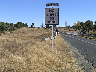
Rocky River, a watercourse of the Gwydir catchment within the Murray–Darling basin, is located in the Northern Tablelands district of New South Wales, Australia.
Kirrawee High School is a comprehensive co-educational high school located in Kirrawee, New South Wales, Australia, adjacent to the Royal National Park.
The Commissioners Waters, a watercourse that is part of the Macleay River catchment, is located in the Northern Tablelands region of New South Wales, Australia.

Greenhills Beach is an unpatrolled beach on Bate Bay, located in Kurnell, New South Wales. The beach is located roughly 18 kilometres from the Sydney central business district, in the local government area of the Sutherland Shire. Recognised as one of Sydney's longest beaches, Greenhills beach is roughly 3 kilometres in length and forms part of a chain of beaches residing on Bate Bay. It is the northernmost section of the Greenhills-North Cronulla beach complex and is the only section of the beach not to be patrolled by a Surf Club or by volunteer lifesavers.
Gwawley Bay is a bay on the Georges River located in New South Wales, Australia. Gwawley Creek runs into the bay.
