
Sobieszewo Island is an island on the Baltic sea, between the Gdańsk Bay and the delta of Vistula river. The island is part of the territory of the city of Gdańsk, Poland.
Masnedø is a Danish island between Zealand and Falster. The island covers an area of 1.68 km² and has 156 inhabitants.

Eversberg is a town with about 2000 inhabitants in the county of North Rhine-Westphalia, Germany.

The Ūla is a river in Dzūkija National Park in southern Lithuania and northern Belarus.

International Business School at Vilnius University or VU IBS is a private university in Lithuania. VU IBS was established by Vilnius University, but now is an independent institution offering bachelor's, master's, and professional degrees in business, management and economics.
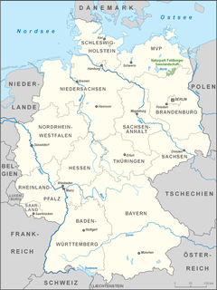
The Feldberg Lake District Nature Park lies in the southeast of the German state of Mecklenburg-Vorpommern in the district of Mecklenburgische Seenplatte. A large part of the nature park lies within the municipality of the same name, the Feldberger Seenlandschaft. In addition the municipalities of Wokuhl-Dabelow, Grünow, Carpin, Godendorf and parts of the towns of Woldegk and Neustrelitz fall within the nature park. The western end of the park is also a part of Müritz National Park.

Sobienie Kiełczewskie Pierwsze is a village in Otwock County, Gmina Sobienie-Jeziory.The population is near 200. In the village is Voivodship Road 801. It lies approximately 3 kilometres (2 mi) south-east of Sobienie-Jeziory, 23 km (14 mi) south of Otwock, and 41 km (25 mi) south-east of Warsaw.
Jazy is a village in the administrative district of Gmina Płaska, within Augustów County, Podlaskie Voivodeship, in north-eastern Poland, close to the border with Belarus. It lies approximately 8 kilometres (5 mi) east of Płaska, 27 km (17 mi) east of Augustów, and 87 km (54 mi) north of the regional capital Białystok.
Rowele is a village in the administrative district of Gmina Rutka-Tartak, within Suwałki County, Podlaskie Voivodeship, in north-eastern Poland, close to the border with Lithuania. It lies approximately 29 kilometres (18 mi) north of Suwałki and 137 km (85 mi) north of the regional capital Białystok.

Giləzi is a village in the Siazan Rayon of Azerbaijan.
Wodnica-Kolonia is a settlement in the administrative district of Gmina Ustka, within Słupsk County, Pomeranian Voivodeship, in northern Poland. It lies approximately 5 kilometres (3 mi) south-east of Ustka, 13 km (8 mi) north-west of Słupsk, and 115 km (71 mi) west of the regional capital Gdańsk.
Glitajny is a village in the administrative district of Gmina Bartoszyce, within Bartoszyce County, Warmian-Masurian Voivodeship, in northern Poland, close to the border with the Kaliningrad Oblast of Russia.
Łysogóra is a village in the administrative district of Gmina Dubeninki, within Gołdap County, Warmian-Masurian Voivodeship, in northern Poland, close to the border with the Kaliningrad Oblast of Russia. It lies approximately 13 kilometres (8 mi) north-east of Dubeninki, 28 km (17 mi) east of Gołdap, and 159 km (99 mi) north-east of the regional capital Olsztyn.
Muławki is a village in the administrative district of Gmina Kętrzyn, within Kętrzyn County, Warmian-Masurian Voivodeship, in northern Poland. It lies approximately 5 kilometres (3 mi) south-west of Kętrzyn and 63 km (39 mi) north-east of the regional capital Olsztyn.
Ługowo is a village in the administrative district of Gmina Pełczyce, within Choszczno County, West Pomeranian Voivodeship, in north-western Poland. It lies approximately 4 kilometres (2 mi) south-east of Pełczyce, 18 km (11 mi) south of Choszczno, and 68 km (42 mi) south-east of the regional capital Szczecin.
Ślizno is a village in the administrative district of Gmina Kalisz Pomorski, within Drawsko County, West Pomeranian Voivodeship, in north-western Poland. It lies approximately 7 kilometres (4 mi) north of Kalisz Pomorski, 23 km (14 mi) south of Drawsko Pomorskie, and 86 km (53 mi) east of the regional capital Szczecin.
Jeżyczki-Kolonia is a settlement in the administrative district of Gmina Darłowo, within Sławno County, West Pomeranian Voivodeship, in north-western Poland. It lies approximately 9 kilometres (6 mi) south of Darłowo, 18 km (11 mi) west of Sławno, and 158 km (98 mi) north-east of the regional capital Szczecin.
The rue Molière is a short road in central Paris, in the 1st arrondissement. It begins at avenue de l'Opéra, near the Comédie-Française, and ends at the rue de Richelieu with the Fontaine Molière.

Stainton Pike is a hill in the English Lake District, near Waberthwaite, Cumbria. It is the subject of a chapter of Wainwright's book The Outlying Fells of Lakeland. It reaches 1,550 feet (470 m) and Wainwright's anticlockwise circuit also visits The Knott at 1,071 feet (326 m). The walk also passes the waterfall Rowantree Force and collection of ancient enclosures and hut circles known as Barnscar or City of Barnscar.

The Park an der Ilm is a large Landschaftspark in Weimar, Thuringia. It was created in the 18th century, influenced by Johann Wolfgang von Goethe, and has not been changed much, preserving a park of the period. It forms part of the World Heritage Site "Classical Weimar".


