A tuna is a saltwater fish that belongs to the tribe Thunnini, a subgrouping of the Scombridae (mackerel) family. The Thunnini comprise 15 species across five genera, the sizes of which vary greatly, ranging from the bullet tuna up to the Atlantic bluefin tuna, which averages 2 m (6.6 ft) and is believed to live up to 50 years.

The Andaman Sea is a marginal sea of the northeastern Indian Ocean bounded by the coastlines of Myanmar and Thailand along the Gulf of Martaban and west side of the Malay Peninsula, and separated from the Bay of Bengal to its west by the Andaman Islands and the Nicobar Islands. Its southern end is at Breueh Island just north of Sumatra, with the Strait of Malacca further southeast.

Ilocos Norte, is a province of the Philippines located in the Ilocos Region. Its capital is Laoag City, located in the northwest corner of Luzon Island, bordering Cagayan and Apayao to the east, and Abra to the southeast, and Ilocos Sur to the southwest. Ilocos Norte faces the West Philippine Sea to the west and the Luzon Strait to the north.

Ilocos Region is an administrative region of the Philippines, designated as Region I, occupying the northwestern section of Luzon and part of Central Luzon plain, primarily by Pangasinan. It is bordered by the Cordillera Administrative Region to the east, the Cagayan Valley to the northeast and southeast, and the Central Luzon to the south. To the west lies the South China Sea.

Big-game fishing, also known as offshore sportfishing, offshore gamefishing or blue-water fishing, is a form of recreational fishing targeting large game fish, usually done on a large body of water such as the ocean.
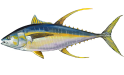
The yellowfin tuna is a species of tuna found in pelagic waters of tropical and subtropical oceans worldwide.

Laoag, officially known as the City of Laoag, is a 3rd class component city and capital of the province of Ilocos Norte, Philippines. According to the 2020 census, it has a population of 111,651 people.

Pagudpud, officially the Municipality of Pagudpud, is a 4th class municipality in the province of Ilocos Norte, Philippines. According to the 2020 census, it has a population of 25,098 people.
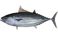
The skipjack tuna is a medium-sized perciform fish in the tuna family, Scombridae. It is otherwise known as the balaya, bakulan/kayu, tongkol/aya, cakalang (Indonesia), katsuo, arctic bonito, mushmouth, oceanic bonito, striped tuna or victor fish. It grows up to 1 m (3 ft) in length. It is a cosmopolitan pelagic fish found in tropical and warm-temperate waters. It is a very important species for fisheries.
A fish aggregatingdevice (FAD) is a man-made object used to attract ocean-going pelagic fish such as marlin, tuna and mahi-mahi. They usually consist of buoys or floats tethered to the ocean floor with concrete blocks. FADs attract fish for numerous reasons that vary by species.
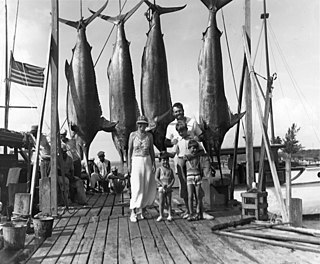
Marlin fishing is considered by some game fishermen to be a pinnacle of offshore game fishing, due to the size and power of the four marlin species and their relative rareness. Fishing for marlin captured the imagination of some sport fishermen in the 1930s, when well-known angler/authors Zane Grey, who fished for black, striped, and blue marlin in the Pacific, and Ernest Hemingway, who fished the Florida Keys, Bahamas and Cuba for Atlantic blue marlin and white marlin, wrote extensively about their pursuit and enthused about the sporting qualities of their quarry.

The little tunny, also known as the false albacore, little tuna, bonita, bonito, or blue bonito, is a species of tuna in the family Scombridae. It can be found in the Atlantic Ocean and the Mediterranean and Black seas; in the western Atlantic, it ranges from Brazil to the New England states. The little tunny is a pelagic fish that can be found regularly in both offshore and inshore waters, and it is classified as a highly migratory species. The little tunny is best identified by the "worm-like" markings on its back and the dark spots appearing between its pectoral and ventral fins.
Land-based game fishing is a form of big-game sport fishing in which anglers attempt to catch oceanic game fish from shore rather than from ocean-going boats. The locations for such activities are generally rock platforms, though wharfs, jetties and beaches are also common. Some species such as sharks can be targeted in shallow littoral water, however most other species prefer deeper pelagic water, and this limits the areas where these types can be fished from the shore. Tackle used is usually comparable to that used on boats, but some differences are necessary, such as changes in rod length. Different tackle is used according to location and species targeted.
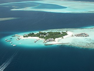
The fishing industry in the Maldives is the island's second main industry. According to national tradition in the words of former President Maumoon Abdul Gayoom, "Fishing is the lifeblood of our nation, it is inborn. From the soil on which we live, to the sea around us, it remains an integral part of our existence. Fishing, and our country and its people, [are] one and shall remain inseparable forever." The Maldives has an abundance of aquatic life and species of fish. Common are tuna, groupers, dolphin fish, barracuda, rainbow runner, trevally and squirrelfish and many more. Aside from being of essential importance to the economy, fishing is also a popular recreational activity in the Maldives, not only among locals but by tourists. The islands have numerous fishing resorts which cater for these activities.
International Seafood Sustainability Foundation (ISSF) was formed in 2009 as a global, non-profit partnership among the tuna industry, scientists and World Wide Fund for Nature. The multistakeholder group states its mission is "to undertake science-based initiatives for the long-term conservation and sustainable use of tuna stocks, reducing bycatch and promoting ecosystem health". Regional Fisheries Management Organizations (RFMOs) are primarily responsible for managing the world's tuna stocks—skipjack, yellowfin and albacore tuna, the species most commonly processed for canned and shelf-stable tuna products, but their parliamentary procedures too often allow the short-term economic and political interests of nations to prevent sustainable measures from being adopted. ISSF works to ensure that effective international management practices are in place to maintain the health of all the tuna stocks.

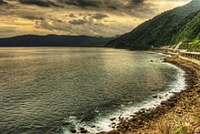
The Patapat Viaduct, also known as Patapat Bridge, is a viaduct at the municipality of Pagudpud, Ilocos Norte, a coastal resort town on the northernmost tip of Luzon Island in the Philippines.
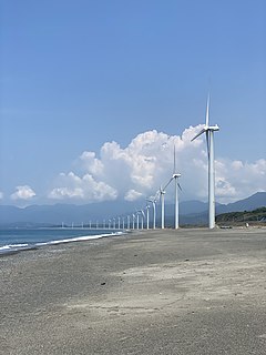
Wind power in the Philippines accounts for a total of 443MW as of 2020 according to the Department of Energy, covering about 1.6% of the country's total installed capacity for both renewable and non-renewable energy sources. When it comes to existing renewable energy sources in the country, wind power has a total share of approximately 5.4%. Despite currently being a small contributor to the country's energy mix, wind power installations have increased from 33MW in 2012-2013 to 337MW in 2014, 427MW in 2015-2018, and 443MW in 2019-2021. Moreover, the Department of Energy's National Renewable Energy Plan (NREP) 2020-2040 aims to commission 2,345MW of total wind power capacity by 2030. There has been a setback, however, as the wind power industry was moderately affected by COVID, particularly in the import of wind turbines. Due to this, several projects such as the Aklan onshore wind project got delayed. To further drive the wind energy sector in the country, an increased demand for renewable energy, greater government commitments, and reduced wind power tariff are needed.
The Condor seamount is a submarine mountain located at 17 kilometres (11 mi) west-southwest of Faial Island in the Azores. It is approximately 1,800 metres (5,900 ft) high, 39 kilometres (24 mi) long and 23 kilometres (14 mi) wide, stretching from a depth of 185 metres (607 ft) up to 2,003 metres (6,572 ft). It is an elongated shaped volcano, oriented east-west, with the top relatively flat with smooth sedimentary flanks. Most seamounts lie in deep sea and/or open ocean, and thus are inaccessible and difficult to study. The Condor bank, constitutes an interesting case study due to its accessibility, located close to Faial island.

US FWS Hugh M. Smith was an American fisheries science research vessel in commission from 1949 to 1959 in the fleet of the United States Department of the Interior's Fish and Wildlife Service. She was among the first U.S. fisheries science vessels to explore the central Pacific Ocean in search of commercially valuable populations of fish.

US FWS Charles H. Gilbert was an American fisheries science research vessel in commission from 1952 to 1970 in the fleet of the United States Department of the Interior's Fish and Wildlife Service and from 1970 to 1973 in the fleet of the National Oceanic Atmospheric Administration as NOAAS Charles H. Gilbert. She was among the first U.S. fisheries science vessels to explore the central Pacific Ocean in search of commercially valuable populations of fish.