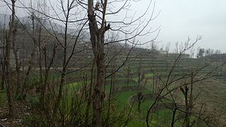
Dir is a region in northwestern Pakistan in the Khyber Pakhtunkhwa, in the foothills of the Himalayas. Before Pakistan was created, Dir was a princely state, and it remained so until 1969 when it was abolished by a presidential declaration, and the Dir District was created the following year. The area covers 5,280 square kilometres. In 1996 it was divided into Lower Dir and Upper Dir.

Lower Dir District is a district of Khyber Pakhtunkhwa province in Pakistan. Timergara city is the district headquarter and largest city, while the other small cities are Chakdara, Munda, Samar Bagh, Khall and Kumbar.
Kotigram is an administrative unit known as “Union Council” of Lower Dir District in the Khyber Pakhtunkhwa province of Pakistan.
Nehag is an administrative unit, known as Union Council, of Upper Dir District in the Khyber Pakhtunkhwa province of Pakistan.

Patrak is an administrative unit, known as Union Council, of Upper Dir District in the Khyber Pakhtunkhwa province of Pakistan. Patrak located in the middle of two river named Guwaldi River and Komrat River.
Palam is an administrative unit, known as Union Council, of Upper Dir District in the Khyber Pakhtunkhwa province of Pakistan.
Sawni is an administrative unit, known as Union Council, of Upper Dir District in the Khyber Pakhtunkhwa province of Pakistan.
Sheringal is an administrative unit, known as Union Council, of Upper Dir District in the Khyber Pakhtunkhwa province of Pakistan.
Shalfalam is an administrative unit, known as Union Council, of Upper Dir District in the Khyber Pakhtunkhwa province of Pakistan.
Sundalm is an administrative unit, known as Union Council, of Upper Dir District in the Khyber Pakhtunkhwa province of Pakistan.
Taraptar is an administrative unit known as a Union Council. It is in the Upper Dir District in the Khyber Pakhtunkhwa province of Pakistan.
Qolundy is an administrative unit, known as Union Council, of Upper Dir District in the Khyber Pakhtunkhwa province of Pakistan.
Wari is a tehsil located in Upper Dir District, Khyber Pakhtunkhwa, Pakistan.

Darorra is an administrative unit known as "Union Council" of Upper Dir District in the Khyber Pakhtunkhwa province of Pakistan.
Ganori is an administrative unit known as "Union Council" of Upper Dir District in the Khyber Pakhtunkhwa province of Pakistan.
Gwaldi is an administrative unit known as "Union Council" of Upper Dir District in the Khyber Pakhtunkhwa province of Pakistan.
Dir is an administrative unit known as "Union Council" of Upper Dir District in the Khyber Pakhtunkhwa province of Pakistan.
Shah Pur is an administrative unit known as the "Union Council" of the Kohat District in the Khyber Pakhtunkhwa province of Pakistan.
Bar Abakhel is an administrative unit, known as Union council, of Swat District in the Khyber Pakhtunkhwa province of Pakistan. District Swat has 9 Tehsils i.e. Khwazakhela, Kabal, Madyan, Barikot, Mingora, and Kalam. Each Tehsill comprises certain numbers of union councils. There are 65 union councils in district Swat, 56 rural and 09 urban.
Shalpin is an administrative unit, known as Union council, of Swat District in the Khyber Pakhtunkhwa province of Pakistan. Union council Shalpin has 3 village councils i.e. Shalpin, Faqira and Bawrai. Village council Faqira includes the following villages: Faqira, Banda, Sholgara and Karal etc. Shalpin is a village of Swat District situated 32 kilometres away from Mingaora. Elevation of the area is 4,300 ft. The most cultivated crops of the area are Wheat and Maize. Shalpin is also famous for its fruits like Peaches locally named is Shaltaloo, Apricots and Persimons. The Shalpin valley is diverse in vegetation. Pashtu is the most common language although few families in the mountain areas maybe speaking kohistani and gujri. Shalpin has a public high School for boys and girls and two private middle Schools. Shalpin also has a basic health Unit. People of Shalpin are highly educated and several alumni of high school are serving at different key positions in the country and abroad.
This page is based on this
Wikipedia article Text is available under the
CC BY-SA 4.0 license; additional terms may apply.
Images, videos and audio are available under their respective licenses.


