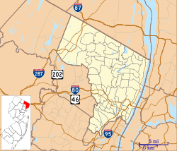
Bergen County is the most populous county in the U.S. state of New Jersey. Located in the northeastern corner of New Jersey, Bergen County and its many inner suburbs constitute a highly developed part of the New York City metropolitan area, bordering the Hudson River; the George Washington Bridge, which crosses the Hudson, connects Bergen County with Manhattan. The county is part of the North Jersey region of the state.

Route 17 is a state highway in Bergen County, New Jersey, United States, that provides a major route from the George Washington Bridge, Lincoln Tunnel and other northeast New Jersey points to the New York State Thruway at Suffern, New York. It runs 27.20 mi (43.77 km) from an intersection with Route 7 and County Route 507 (CR 507) in North Arlington north to the New York state line along Interstate 287 (I-287) in Mahwah, where New York State Route 17 (NY 17) continues into New York. Between Route 7 and Route 3 in Rutherford, Route 17 serves as a local road. From Route 3 north to the junction with U.S. Route 46 (US 46) in Hasbrouck Heights, the road is an arterial road with jughandles. The portion of Route 17 from US 46 to I-287 near the state line in Mahwah is a four- to six-lane arterial with all cross traffic handled by interchanges, and many driveways and side streets accessed from right-in/right-out ramps from the right lane. For three miles (5 km) north of Route 4, well over a hundred retail stores and several large shopping malls line the route in the borough of Paramus. The remainder of this portion of Route 17 features lighter suburban development. The northernmost portion of Route 17 in Mahwah runs concurrently with I-287 to the New York state line.

Fair Lawn is a borough in Bergen County, in the U.S. state of New Jersey, and a bedroom suburb located 12 miles (19 km) northwest of New York City. As of the 2020 United States census, the borough's population was 34,927, an increase of 2,470 (+7.6%) from the 2010 census count of 32,457, which in turn reflected an increase of 820 (+2.6%) from the 31,637 counted in the 2000 census.

Saddle Brook is a township in Bergen County, in the U.S. state of New Jersey. As of the 2020 United States census, the township's population was 14,294, an increase of 635 (+4.6%) from the 2010 census count of 13,659, which in turn reflected an increase of 504 (+3.8%) from the 13,155 counted in the 2000 census. It is also home of
Garfield is a city in Bergen County in the U.S. state of New Jersey. As of the 2020 United States census, the city's population was 32,655, an increase of 2,168 (+7.1%) from the 2010 census count of 30,487, which in turn reflected an increase of 701 (+2.4%) from the 29,786 counted in the 2000 census.

The Passaic River is a river, approximately 80 miles (130 km) long, in Northern New Jersey. The river in its upper course flows in a highly circuitous route, meandering through the swamp lowlands between the ridge hills of rural and suburban northern New Jersey, called the Great Swamp, draining much of the northern portion of the state through its tributaries.

The New York, Susquehanna and Western Railway, also sometimes referred to as New York, Susquehanna and Western Railroad, Susie-Q or the Susquehanna, is a Class II American freight railway operating over 400 miles (645 km) of track in three Northeastern states, New Jersey, New York, and Pennsylvania.

The Main Line is a commuter rail line owned and operated by New Jersey Transit running from Suffern, New York to Hoboken, New Jersey, in the United States. It runs daily commuter service and was once the north–south main line of the Erie Railroad. It is colored yellow on NJ Transit system maps, and its symbol is a water wheel.

The Bergen County Line is a commuter rail line and service owned and operated by New Jersey Transit in the U.S. state of New Jersey. The line loops off the Main Line between the Meadowlands and Glen Rock, with trains continuing in either direction along the Main Line. It is colored on NJT system maps in grey, and its symbol is a cattail, which are commonly found in the Meadowlands where the line runs.
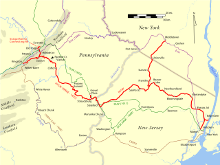
The New Jersey Midland Railway was a 19th-century predecessor to the New York, Susquehanna and Western Railway (NYS&W) that operated in Northern New Jersey and Orange County, New York.

The Saddle River flows south through much of Bergen County, New Jersey. The river runs through densely populated suburban areas for much of its course. The river takes its name from the river near Saddell in Argyll and Bute in Scotland.

Ho-Ho-Kus Brook is a tributary of the Saddle River in Bergen County, New Jersey, in the United States.
New Jersey's 9th congressional district is an urban congressional district in the U.S. state of New Jersey, and was represented in Congress by Democrat Bill Pascrell until his death in 2024, first elected in 1996 from the old 8th district. The 9th district consists largely of municipalities in Bergen and Passaic Counties.
New Jersey's 5th congressional district is represented by Democrat Josh Gottheimer, who has served in Congress since 2017. The district stretches across the entire northern border of the state and contains most of Bergen County, as well as parts of Passaic County and Sussex County.

Glen Rock–Main Line is one of two railroad stations operated by New Jersey Transit in the borough of Glen Rock, Bergen County, New Jersey, United States on the Main Line. The station is named Glen Rock–Main Line to differentiate it from the Glen Rock–Boro Hall station, which lies two blocks east on Rock Road.
Ramsey is one of two railroad stations operated by New Jersey Transit in the borough of Ramsey, Bergen County, New Jersey, United States. Located on the Main Line and Bergen County Line, Ramsey station is also unofficially known as Ramsey – Main Street due to the opening of Ramsey Route 17 station to the north in 2004.

The Passaic–Bergen–Hudson Transit Project is a project under study by NJ Transit to reintroduce passenger service on a portion of the New York, Susquehanna and Western Railway (NYSW) right-of-way (ROW) in Passaic, Bergen and Hudson counties using newly built, FRA-compliant diesel multiple unit rail cars. Plans call for service to run from Hawthorne south through Paterson, east to Hackensack and then southeast to North Bergen, where it would join the Hudson-Bergen Light Rail (HBLR).

West Hudson is the western part of Hudson County, New Jersey comprising the contiguous municipalities of Kearny, Harrison and East Newark, which lies on the peninsula between the Hackensack River and Passaic River.
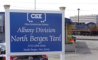
The North Bergen Yard is freight rail yard and intermodal terminal in North Bergen, New Jersey parallel to Tonnelle Avenue between 49th and 69th Streets. Located within the North Jersey Shared Assets Area, the facility is part of CSX Transportation (CSXT) and the origination point of its CSX River Subdivision at the southern end of the Albany Division. On its west side, the New York, Susquehanna and Western Railway (NYSW) runs the length of the yard and operates a bulk transloading operation immediately adjacent to it.

The Edgewater Branch was a branch of the New York, Susquehanna and Western Railway (NYS&W) that ran about 3.174 miles (5.108 km) through eastern Bergen County, New Jersey in the United States. Starting from a rail junction at the Little Ferry Yard, it went east through the Edgewater Tunnel to Undercliff to the Hudson Waterfront.