
The Shire of Campaspe is a local government area in Victoria, Australia, located in the northern part of the state. It covers an area of 4,519 square kilometres (1,745 sq mi) and in June 2018 had a population of 37,592.

The Shire of Hepburn is a local government area in Victoria, Australia, located in the central part of the state. It covers an area of 1,473 square kilometres (569 sq mi) and, in June 2018 had a population of 15,812.

The Shire of Macedon Ranges is a region in Central Victoria, Australia, best known for its expansive native forests, iconic geographical attraction Hanging Rock, and thriving artisan food and wine industries. The region covers an area of 1,748 square kilometres (675 sq mi). It is located in between the cities of Bendigo and Melbourne. In June 2018 the shire had a population of 49,388. It includes the towns of Gisborne, Kyneton, Lancefield, Macedon, Malmsbury, Mount Macedon, New Gisborne, Riddells Creek, Romsey and Woodend.

The Shire of Moorabool is a local government area in Victoria, Australia, located in the western part of the state. It covers an area of 2,111 square kilometres (815 sq mi) and, in June 2018, had a population of 34,158. It includes the towns of Ballan, Bacchus Marsh, Balliang, Mount Wallace, Myrniong, Blackwood, Greendale, Gordon, Korweinguboora and Mount Egerton, Bungaree, Elaine and Wallace. It was formed in 1994 from the amalgamation of the Shire of Bacchus Marsh, Shire of Ballan and parts of the Shire of Bungaree and City of Werribee.

The Mount Alexander Shire is a local government area in Victoria, Australia, located in the central part of the state. It covers an area of 1,530 square kilometres (590 sq mi) and, in June 2018, had a population of 19,514. It includes the towns of Castlemaine, Chewton, Elphinstone, Maldon, Newstead, Harcourt, Taradale, Vaughan, Fryerstown and Campbells Creek. It was formed in 1995 from the amalgamation of the City of Castlemaine, Shire of Newstead, and most of the Shire of Maldon and Shire of Metcalfe. The traditional owners of the land are Dja Dja Wurrung.
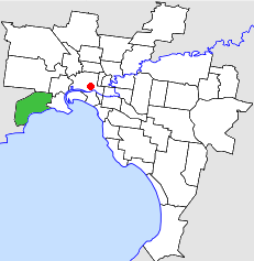
The City of Altona was a local government area about 13 kilometres (8 mi) west of Melbourne, the state capital of Victoria, Australia. The city covered an area of 40.18 square kilometres (15.51 sq mi), and existed from 1957 until 1994.
The Shire of Bulla was a local government area located about 40 kilometres (25 mi) northwest of Melbourne, the state capital of Victoria, Australia. The shire covered an area of 422.17 square kilometres (163.0 sq mi), and existed from 1862 until 1994.
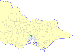
The Shire of Kilmore was a local government area about 60 kilometres (37 mi) north of Melbourne, the state capital of Victoria, Australia. The shire covered an area of 508.9 square kilometres (196.5 sq mi), and existed from 1856 until 1995.

The Shire of Gisborne was a now-defunct local government area northwest of Melbourne until its abolition in 1995, when the Shire of Macedon Ranges was created from the merging of the Shires of Gisborne, Newham and Woodend, Romsey, and parts of the Shire of Kyneton.

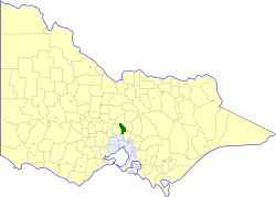
The Shire of Kyneton was a local government area about 85 kilometres (53 mi) northwest of Melbourne, the state capital of Victoria, Australia. The shire covered an area of 725.2 square kilometres (280.0 sq mi), and existed from 1859 until 1995.
The Shire of Maldon was a local government area about 140 kilometres (87 mi) northwest of Melbourne, the state capital of Victoria, Australia, and 35 kilometres (22 mi) southwest of the regional city of Bendigo. The shire covered an area of 549 square kilometres (212.0 sq mi), and existed from 1858 until 1995.

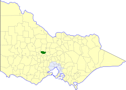
The Shire of Metcalfe was a local government area about 105 kilometres (65 mi) north-northwest of Melbourne, the state capital of Victoria, Australia, and 45 kilometres (28 mi) south of the regional city of Bendigo. The shire covered an area of 590.52 square kilometres (228.0 sq mi), and existed from 1860 until 1995.

The Shire of Newham and Woodend was a local government area about 70 kilometres (43 mi) northwest of Melbourne, the state capital of Victoria, Australia. The shire covered an area of 246.05 square kilometres (95.0 sq mi), and existed from 1861 until 1995.

The Shire of Pyalong was a local government area about 85 kilometres (53 mi) north of Melbourne, the state capital of Victoria, Australia. The shire covered an area of 577.57 square kilometres (223.0 sq mi), and existed from 1863 until 1994.

The Shire of Romsey was a local government area about 65 kilometres (40 mi) north-north-west of Melbourne, the state capital of Victoria, Australia. The shire covered an area of 628 square kilometres (242.5 sq mi), and existed from 1862 until 1995.

The Shire of Bacchus Marsh was a local government area about 50 kilometres (31 mi) west of Melbourne, the state capital of Victoria, Australia. The shire covered an area of 565 square kilometres (218.1 sq mi), and existed from 1862 until 1994.

The Shire of Ballan was a local government area about 75 kilometres (47 mi) west of Melbourne, the state capital of Victoria, Australia. The shire covered an area of 919.45 square kilometres (355.0 sq mi), and existed from 1862 until 1994.

Pastoria is a census-designated place (CDP) in Accomack County, Virginia, United States. The population as of the 2010 Census was 649.

The Shire of Hann is a former local government area in Far North Queensland, Australia.

Desailly is a rural locality in the Shire of Mareeba, Queensland, Australia. In the 2016 census Desailly had a population of 0 people.