
The Shire of Macedon Ranges is a region in Central Victoria, Australia, best known for its native forests, geographical attraction Hanging Rock, and artisan food and wine industries. The region covers an area of 1,748 square kilometres (675 sq mi). It is located in between the cities of Bendigo and Melbourne. In August 2021 the shire had a population of 51,458. It includes the towns of Gisborne, Gisborne South, Kyneton, Lancefield, Macedon, Malmsbury, Mount Macedon, New Gisborne, Riddells Creek, Romsey and Woodend.

Kyneton is a town in the Macedon Ranges region of West Central Victoria, Australia. The Calder Freeway bypasses Kyneton to the north and east. Kyneton is on Dja Dja Wurrung, Taungurung and Wurundjeri Woi Wurrung country.

Newham is a town in the Shire of Macedon Ranges in Victoria, Australia. It is situated between the towns of Kyneton, Woodend and Lancefield. At the 2006 census, the surrounding area had a population of 570. At the 2016 census, Newham and the surrounding area had a population of 506.
The Shire of Bulla was a local government area about 40 kilometres (25 mi) northwest of Melbourne, the state capital of Victoria, Australia. The shire covered an area of 422.17 square kilometres (163.0 sq mi), and existed from 1862 until 1994.
The Shire of Healesville was a local government area about 60 kilometres (37 mi) northeast of Melbourne, the state capital of Victoria, Australia. The shire covered an area of 466.20 square kilometres (180.0 sq mi), and existed from 1887 until 1994.
The Shire of Kilmore was a local government area about 60 kilometres (37 mi) north of Melbourne, the state capital of Victoria, Australia. The shire covered an area of 508.9 square kilometres (196.5 sq mi), and existed from 1856 until 1995.

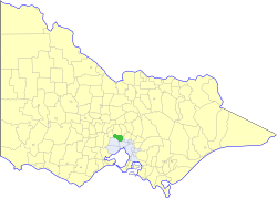
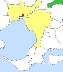
The Shire of Kyneton was a local government area about 85 kilometres (53 mi) northwest of Melbourne, the state capital of Victoria, Australia. The shire covered an area of 725.2 square kilometres (280.0 sq mi), and existed from 1859 until 1995.
The Shire of Maldon was a local government area about 140 kilometres (87 mi) northwest of Melbourne, the state capital of Victoria, Australia, and 35 kilometres (22 mi) southwest of the regional city of Bendigo. The shire covered an area of 549 square kilometres (212.0 sq mi), and existed from 1858 until 1995.

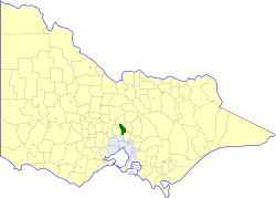
The Shire of Newham and Woodend was a local government area about 70 kilometres (43 mi) northwest of Melbourne, the state capital of Victoria, Australia. The shire covered an area of 246.05 square kilometres (95.0 sq mi), and existed from 1861 until 1995.

The Shire of Newstead was a local government area about 120 kilometres (75 mi) northwest of Melbourne, the state capital of Victoria, Australia. The shire covered an area of 409.22 square kilometres (158.0 sq mi), and existed from 1860 until 1995.

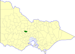
The Shire of Romsey was a local government area about 65 kilometres (40 mi) north-north-west of Melbourne, the state capital of Victoria, Australia. The shire covered an area of 628 square kilometres (242.5 sq mi), and existed from 1862 until 1995.

The Shire of Woorayl was a local government area about 130 kilometres (81 mi) southeast of Melbourne, the state capital of Victoria, Australia. The shire covered an area of 1,245.79 square kilometres (481.0 sq mi), and existed from 1888 until 1994.

The Shire of Omeo was a local government area about 390 kilometres (242 mi) east-north-east of Melbourne, the state capital of Victoria, Australia. The shire covered an area of 5,641 square kilometres (2,178.0 sq mi), and existed from 1872 until 1994.

The City of Colac was a local government area about 150 kilometres (93 mi) west-southwest of Melbourne, the state capital of Victoria, Australia. The city covered an area of 10.88 square kilometres (4.2 sq mi), and existed from 1938 until 1994. Its area was surrounded by the separate and largely rural Shire of Colac.

The Shire of Bacchus Marsh was a local government area about 50 kilometres (31 mi) west of Melbourne, the state capital of Victoria, Australia. The shire covered an area of 565 square kilometres (218.1 sq mi), and existed from 1862 until 1994.

The Shire of Ballan was a local government area about 75 kilometres (47 mi) west of Melbourne, the state capital of Victoria, Australia. The shire covered an area of 919.45 square kilometres (355.0 sq mi), and existed from 1862 until 1994.

The Shire of Creswick was a local government area about 120 kilometres (75 mi) west-northwest of Melbourne, the state capital of Victoria, Australia. The shire covered an area of 551.66 square kilometres (213.0 sq mi), and existed from 1859 until 1995.

The Shire of Daylesford and Glenlyon was a local government area about 110 kilometres (68 mi) northwest of Melbourne, the state capital of Victoria, Australia. The shire covered an area of 609.3 square kilometres (235.3 sq mi), and existed from 1966 until 1995.

Springfield is a locality in the Shire of Macedon Ranges local government area in central Victoria, Australia approximately 65 kilometres north of the state capital, Melbourne. It is within the catchment area of Deep Creek, a tributary of the Maribyrnong River.
Pastoria East is a locality in Victoria, Australia, made up after the Shire of Kyneton merged with the Shires of Gisborne, Newham and Woodend, and Romsey to make up the Shire of Macedon Ranges.

