
Madurai is a major city in the Indian state of Tamil Nadu. It is the cultural capital of Tamil Nadu and the administrative headquarters of Madurai District, which is governed by the Madurai Municipal Corporation established in 1 November 1866. As of the 2011 census, it is the third largest metropolis in Tamil Nadu after Chennai and Coimbatore in terms of population and 27th largest urban agglomeration in India. Located on the banks of River Vaigai, Madurai has been a major settlement for two millennia and has a documented history of more than 2500 years. It is often referred to as "Thoonga Nagaram", meaning "the city that never sleeps".

Tirunelveli, also known as Nellai and historically as Tinnevelly, is a major city in the Indian state of Tamil Nadu. It is the administrative headquarters of the Tirunelveli District. It is the fourth-largest municipal corporation in the state after Chennai, Coimbatore, and Madurai. Tirunelveli is located 624 km (388 mi) southwest of the state capital Chennai, 58 km (36 mi) away from Thoothukudi, and 73 km (45 mi) from Kanyakumari. The downtown is located on the west bank of the Thamirabarani River; its twin Palayamkottai is on the east bank. Palayamkottai is called the Oxford of South India as it has many schools and colleges. It has several important government offices.

Tiruvallur is a Grade I municipality in the Indian state of Tamil Nadu. It is located on the banks of Coovum river about 46 km (29 mi) from downtown Chennai (Madras) and just 5 km from megacity border, in the western part of the Chennai Metropolitan Area (CMA). It is a satellite town of Chennai and is the administrative headquarters of Tiruvallur District. The town is known for the Veeraraghava Swamy Temple, one of the 108 sacred shrines of Vaishnavites. The tank festival is held at a pond near this temple. A Shiva temple near this shrine which is popular among the locals. There is also a 40-foot (12 m) tall Viswaroopa Panchamukha Hanuman temple, where the murti is made of a single green granite stone.

Dindigul and Tiṇḍukkal is the romanized spelling from Tamil script.}} is a city in the Indian state of Tamil Nadu. It is the administrative headquarters of the Dindigul district. Dindigul is located 420 km (260 mi) southwest from the state capital, Chennai, 100 km (62 mi) away from Tiruchirappalli, 105 km (65 mi) away from Karaikudi, 66 km (41 mi) away from Madurai and 72 km away from the Tex City of Karur. The city is known for its locks and biryani. Parts of Dindigul Districts like Palani, Oddanchatram, Vedasandur, Nilakottai, Kodaikanal, Natham, Athoor.

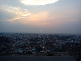
Tirumangalam is a town and municipality in the Madurai District of the Indian state of Tamil Nadu also called as 'Thoongaa Nagarathin Thunai Nagaram' ..
Hosur is an industrial city located in Krishnagiri district in the Tamil Nadu state of India. Hosur is one of the 21 municipal corporations in Tamil Nadu. It is located on the bank of the river River Ponnaiyar, 40 kilometres (25 mi) southeast of Bengaluru and 306 kilometres (190 mi) west of Chennai, the state capital. Hosur is home to major manufacturing industries including Stellantis, Ashok Leyland, Titan, TVS Motors, Caterpillar, Ather Energy, Schaeffler, and many others.
Vellarada is a border village situated in Thiruvananthapuram district in the state of Kerala, India. It is 42 km from Thiruvananthapuram. It is the southernmost part of Kerala state, sharing its border with Tamil Nadu. Vellarada is said to be the threshold to the high-range areas of the eastern part of Thiruvananthapuram district. The southernmost point of Western Ghats in Kerala is near Vellarada.
Tamil Nadu, a state in South India, has a developed, dense, and modern transportation infrastructure, encompassing both public and private transport. Its capital city Chennai is well-connected by land, sea, and air and serves as a major hub for entry into South India.
Coimbatore is a city in the state of Tamil Nadu, India. Most transportation in the city and suburbs is by road. Coimbatore is well-connected to most cities and towns in India by road, rail, and air, but not through waterways. The city has successful transport infrastructure compared to other Indian cities, though road infrastructures are not well maintained and developed according to the growing needs of transport, making traffic congestion a major problem in the city. A comprehensive transport development plan has been made to address many traffic problems.

Madurai in Tamil Nadu, India, has well-developed transport facilities. Modes of transport in Madurai include road, rail and air. Madurai faces increasing daily traffic problems, so master plans have been prepared to reduce the city traffic and traffic problems in suburbs.
Karisalkalampatti is a village near Sivarakkottai NH7 Main road Thirumangalam[KALLIGUDI ]Taluk in Madurai District of the Indian state of Tamil Nadu. It is located about 9 km from Thirumangalam, 30 km from Madurai, and 520 km from the state capital, Chennai. As of 2011, the village population was about 1,158.
Coimbatore Metro, also known as Kovai Metro, is a proposed rapid transit system for Coimbatore, Tamil Nadu.
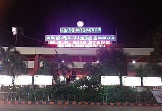
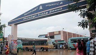
Mattuthavani Bus Stand, officially M.G.R. Bus Stand, is an integrated bus terminus in the city of Madurai, Tamil Nadu, India. This is the third-largest bus terminus in Tamil Nadu after Kalaignar Centenary Bus Terminus and Puratchi Thalaivar Dr. M.G.R. Bus Terminus in Chennai. It is one of the busiest bus terminals in south Tamil Nadu and one of the most important hubs in the state.
Singanallur is a major residential locality of the city of Coimbatore in Tamil Nadu, India. It is located on the banks of Noyyal river, which runs to the southern boundary of the locality. It is situated in the eastern part of the city, and is a major hub for the inter-city bus services towards Southern and Central districts of Tamilnadu from the city. It is one of the well developed neighborhoods in the city and has been part of Coimbatore Corporation since 1981. The East Zone Office of Coimbatore City Municipal Corporation is located at Singanallur.
The Madurai Metropolitan Area, is the 31st largest metropolitan area in India and is the third largest metropolitan area in the state of Tamil Nadu only next to Chennai, and Coimbatore.The Madurai Metropolitan Area consists of the city of Madurai and its suburbs in Madurai district.
Madurai Metro, is a proposed rapid transit system for Madurai, Tamil Nadu. It arose from a Madurai Metrolite system, part of a major expansion of public transport in the city and one of the projects devised by the former Chief Minister of Tamil Nadu J.Jayalalithaa.
Tallakulam or Thallaakulam is located in Madurai district, in the State of Tamil Nadu in India. There is a 'rest mandapam' called 'Ramanathapuram Sethupathi Mandapam' at Tallakulam. During Chithirai festival in the months of April - May, Lord Kallazhagar from Alagar temple visits so many mandapams in and around Madurai on his way to and fro Madurai. This year (2022) also, Lord Kallazhagar began his return journey to Alagarkoil from Ramanathapuram Sethupathi Mandapam at Tallakulam, mounted on 'Poo Pallakku' here at Tallakulam. Most Maduraiites go to have fun at the Tamukkam ground and explore the annual Government Chithirai Exhibition. As many as 90,361 people visited the 212th annual Government Chithirai Exhibition at Tamukkam ground.
Anuppanadi is a neighbourhood in Madurai district of Tamil Nadu state in the peninsular India, located with the geographical coordinates of 9°54′17.3″N78°08′24.4″E and at an altitude of about 152 m above the mean sea level. Madurai, Vandiyur, Anna Nagar, K. K. Nagar, East Gate, South Gate, Goripalayam, Sellur, Simmakkal, Yanaikkal and Nelpettai are some of the important neighbourhoods of Anuppanadi. In the year 1887, excavations carried out at Anuppanadi indicate that Jar burials and earthenware containers were found.
Keelavasal (Keellhavaasal) is a neighborhood in Madurai of Tamil Nadu state in the peninsular India.
