Patterson's Spade Mill

Last updated
Patterson's Spade Mill
Pattersons Spade Mill, Carnanee (geograph 4222604).jpg
Patterson's Spade Mill
Location Templepatrick, County Antrim
Coordinates 54°42′N6°02′W / 54.70°N 6.04°W / 54.70; -6.04
TypeIndustrial heritage museum
Website https://www.nationaltrust.org.uk/pattersons-spade-mill

Patterson's Spade Mill is a water-powered spade mill in Templepatrick, County Antrim, Northern Ireland. Initially a flax and corn mill, it was later converted to a paper mill. Ownership passed to the Patterson family, who had been involved in the spade industry for several generations, converting the mill once again.

Contents

The mill was purchased by the National Trust in 1992. It is the last spade mill in operation in situ in the British Isles.

History

There has a been a mill on the site of Patterson's Spade Mill since at least 1770. First used as a flax and corn mill until 1837, it was subsequently converted to use as a paper mill by Robert Sloane, initially employing nineteen people. Sloan's son, William, took over the paper mill, but by 1864 it had been transferred to a company called Diamond & Steen. By 1877 the mill had changed hands again to the Carnanee Paper Mills Company. In the 1880s it was owned by the Ballyclare Paper Mills Company, but by 1891 machinery had been removed and the site was dilapidated. [1]

By 1901 the Moorefield Dyeing and Finishing Company had purchased the former paper mill and converted it to use as a beetling mill for linen. It then became known as Carnanee Beetling Mill. [1] In 1919-1920 the mill once again underwent conversion, this time to facilitate spade production, under the ownership of the Patterson family. [1] [2] [3] Initially called Carnanee Spade Mill, the name changed to Patterson's Spade Mill in the 1950s. [1]

The first record of the Patterson family making spades was made in 1781 in Ballyronan, County Londonderry. [4] When William George Patterson became first owner of the mill c.1920, he was at least the fourth generation of his family to work in the spade-making industry. [5] [4] The family had been previously connected to other spade mills, such as the one at Bushmills distillery. [6] [7] William George died in 1929 and his sons John, Ben, Robert and Fred continued to work in the mill. The spade mill's busiest period was during the 1930s and 1940s. [6]

Commonly in the spade industry, eldest sons inherited the business, and it was John's sons Arnold, Jim, Jack, George and Robert who continued the work. Arnold ultimately went to work at the spade mill at Ulster Folk Museum, while Jack and Robert continued the trade at Patterson's. [6]

In 1990, the last member of the family to make spades at the mill, Robert Patterson, died, and the family decided to sell the property and business. [2] [4] [8]

Buildings

The earliest map of the site from 1770 shows a building connected to the Ballymartin Water by the head race and tail race of what became the early mill. It also shows two further buildings, which may have been early iterations a mill-owners house and workers' cottages. By 1832 there were five buildings on site, including a second building, likely a mill, that was also connected to the head race. The flax mill was powered by a 14 by 4 ft (4.3 by 1.2 m) waterwheel and the corn mill by a waterwheel that measured 10 by 4 ft (3.0 by 1.2 m). Two roads had also been constructed to enable access to the site; one of these connected to a major turnpike. [1]

During the 1837 conversion to the paper-mill, the corn kiln and kiln store were both demolished. The two-storey former corn mill building was extended to form a rag store and engine room. A new machine room was built next to the extended corn mill. The head race and tail race were also altered: the tail race extended so it discharged further down the Ballymartin Water; the head race had its pond expanded in order to power the much larger waterwheels that are recorded in 1862. During the tail race expansion, the mill manager's house was demolished and re-built. The engine room of the paper mill (the formerly extended corn mill) was subsequently converted to work as a beetling mill by 1921. [1]

The head race was also altered from 1974-75 when the M2 motorway section between Sandyknowes and Templepatrick was built. [1] The mill has protected status as a listed building. [9]

Manufacture

The mill is powered by a Leffel Double Turbine Waterwheel Turbine, which was installed by William George Patterson in 1920. It powers a tilt hammer, which is used to shape the blade of a spade. [1] Spade-making with forged heads, such as the ones made at Patterson's, is listed as critically endangered by Heritage Crafts, the advocacy body for traditional crafts and industries in the UK. [10] There are over 150 types of Irish spade, with iron-tipped spades being closely connected to the paludal or maritime regions of Ulster. [10] As of 2003, the mill specialised in making turf and garden spades. [11] A Patterson's spade is owned by television presenter Paul Martin, who has used it during his appearances on Countryfile . [12]

The mill itself has several separate areas of work: an area where the furnace and tilt hammer heat and forge the blades of the spades; another area for finishing, which includes the manufacture of shafts and handles from wood, fitting the blades to the shafts, as well as painting and labelling the spades. [6]

Preservation and restoration

After the mill was put up for sale by the Patterson family, there was clear recognition by the Historic Monuments and Buildings Branch of the Department of the Environment (predecessor of the Historic Environment Division of the Department for Communities), that the site and its processes needed to be recorded and preferably preserved. It was further hoped that an owner could be found who would preserve the historic nature of the site, since it was the last-surviving water-powered spade mill operational in situ in the British Isles. [4] [5] [10]

The property was preserved by the National Trust, who purchased the property in 1992, not just to preserve the physical buildings but to also maintain the tradition of spade forging in Ulster. [4] [13] [14] [15] [16] From 1993-94 buildings were repaired and the water turbine restored. [2] The National Trust also commissioned Jack Crabtree to paint and draw scenes from the mill prior to restoration. [17] Works produced as part of this series are held in the collection of the Ulster Museum, [18] as well as in the National Trust's collections. [19] [20] [21] [22]

Visitor attraction

The mill opened to the public in 1994. [1] Since then several buildings have been restored and interpretative materials have been developed to introduce visitors to the cultural and historical importance of spade production. New spades continue to be forged on site. [4] There is also a display of the many varieties of Irish spade. [23]

In 2008 the museum revived the tradition of a marriage ceremony 'Over the Anvil', welcoming its first couple for their wedding. [24] In 2010 composer Willie Drennan created traditional Irish music inspired by the site. [25]

Related Research Articles

<span class="mw-page-title-main">Watermill</span> Structure that uses a water wheel or turbine

A watermill or water mill is a mill that uses hydropower. It is a structure that uses a water wheel or water turbine to drive a mechanical process such as milling (grinding), rolling, or hammering. Such processes are needed in the production of many material goods, including flour, lumber, paper, textiles, and many metal products. These watermills may comprise gristmills, sawmills, paper mills, textile mills, hammermills, trip hammering mills, rolling mills, wire drawing mills.

<span class="mw-page-title-main">River Cray</span> River

The River Cray is the largest tributary of the Darent. It is the prime river of outer, south-east Greater London, rising in Priory Gardens, Orpington, where rainwater percolates through the chalk bedrock of the Downs to form a pond where the eroded ground elevation gives way to impermeable clay. Initially it flows true to form northwards, past industrial and residential St Mary Cray, through St Paul's Cray and through Foots Cray, where it enters the parkland Foots Cray Meadows, flowing under by Five Arches bridge. It then flows by restored Loring Hall (c.1760), home of the Lord Castlereagh who killed himself there in 1822. It continues through North Cray and Bexley. It neighbours a restored Gothic (architecture) cold plunge bath house, built around 1766 as part of Vale Mascal Estate. It is then joined by the River Shuttle and then continues through the parkland of Hall Place, which was built for John Champneys in 1540. The Cray turns eastward through Crayford and Barnes Cray to join the Darent in Dartford Creek. The Creek is a well-watered partly tidal inlet between Crayford Marshes and Dartford Marshes by a slight projection of land, Crayford Ness. The villages through which the Cray flows are collectively known as "The Crays".

<span class="mw-page-title-main">River Darent</span> River in Kent, England

The Darent is a Kentish tributary of the River Thames and takes the waters of the River Cray as a tributary in the tidal portion of the Darent near Crayford, as illustrated by the adjacent photograph, snapped at high tide. 'Darenth' is frequently found in the spelling of the river's name in older books and maps, Bartholomew's "Canal's and River of England" being one example. Bartholomew's Gazetteer (1954) demonstrates that Darent means "clear water" and separately explains the other name. Considering the River Darent runs on a bed of chalk and its springs rise through chalk, this is not surprising. The original purity of the water was a major reason for the development of paper and pharmaceuticals in the area.

<span class="mw-page-title-main">River Kent</span> River in Cumbria, England

The River Kent is a short river in the county of Cumbria in England. It originates in hills surrounding Kentmere, and flows for around 20 miles (32 km) into the north of Morecambe Bay. The upper reaches and the western bank of the estuary are located within the boundaries of the Lake District National Park. The river flows in a generally north to south direction, passing through Kentmere, Staveley, Burneside, Kendal and Sedgwick. Near Sedgwick, the river passes through a rock gorge which produces a number of low waterfalls. This section is popular with kayakers as it offers high quality whitewater for several days after rain. The village of Arnside is situated on the east bank of the Kent estuary, just above Morecambe Bay, and a tidal bore known as the Arnside Bore forms in the estuary at this point on high spring tides.

Donegore is the name of a hill, a townland, a small cluster of residences, and a civil parish in the historic barony of Antrim Upper, County Antrim, Northern Ireland. Donegore lies approximately 5 miles (8 km) east of Antrim town. 154 acres of the townland lies in the civil parish of Grange of Nilteen.

<span class="mw-page-title-main">Templepatrick</span> Village in County Antrim, Northern Ireland

Templepatrick is a village and civil parish in County Antrim, Northern Ireland. It is 9.2 miles (14.8 km) northwest of Belfast, and halfway between the towns of Ballyclare and Antrim. It is also close to Belfast International Airport and the village has several hotels. Templepatrick is the site of historic Church of Ireland, Presbyterian and the Old Presbyterian Church. It had a population of 1,437 people in the 2011 Census.

<span class="mw-page-title-main">Nether Alderley Mill</span> Historic watermill in Cheshire, England

Nether Alderley Mill is a 16th-century watermill located in Congleton Road, to the south of the village of Nether Alderley, Cheshire, England. It is owned by the National Trust, and is recorded in the National Heritage List for England as a designated Grade II* listed building. It is a unique example of a triple overshot waterwheel system, two of which are in working order. It is one of only four virtually complete corn mills in Cheshire.

<span class="mw-page-title-main">Straid</span> Village in County Antrim, Northern Ireland

Straid is a small village in County Antrim, Northern Ireland, about three miles east of Ballyclare, and about six miles inland from Carrickfergus. It lies at the centre of the townland of Straidlands, in the Civil Parish of Ballynure within the Antrim and Newtownabbey Borough Council area, and in the former barony of Belfast Lower. The village has a congregational church, an Orange hall, and a primary school.

<span class="mw-page-title-main">Hundred of Ruxley</span> Land division in Kent, England

Ruxley was an ancient hundred, a land division in the north west of the county of Kent, England. Its area has been mostly absorbed by the growth of London; with its name currently referring to the Ruxley district. Its former area now corresponds to a majority of the London Borough of Bromley, a large part of the London Borough of Bexley and a small part of the Kent District of Sevenoaks. The hundred was within the Lathe of Sutton-at-Hone, in the west division of Kent.

<span class="mw-page-title-main">River Bourne, Kent</span> River in Kent, England

The River Bourne rises in the parish of Ightham, Kent and flows in a generally south easterly direction through the parishes of Borough Green, Platt, Plaxtol, West Peckham, Hadlow, and East Peckham where it joins the River Medway. In the 18th century the river was known as the Busty or Buster, the Shode or Sheet, but is not known by these names nowadays. A bourne is a type of stream, while shode means a branch of a river.

<span class="mw-page-title-main">Loose Stream</span> Stream in Kent, England

The Loose Stream sometimes called the River Loose or Langley Stream is a tributary of the River Medway notable for the number of watermills that it powered in its short length. It rises in Langley, flows through Boughton Monchelsea, Loose and enters the Medway at Tovil. The river valley is deep sided, and there is much evidence of the paper and wool trades which once flourished here: the stream has been dammed in many places, resulting in many mill ponds.

<span class="mw-page-title-main">River Len</span> River in Kent, England

The River Len is a river in Kent, England. It rises at a spring in Bluebell Woods to the southeast of the village centre of Lenham 0.6 miles (0.97 km) from the source of the River Great Stour; both rise on the Greensand Ridge. Its length is c10 miles (16 km). It enters the River Medway at Maidstone.

<span class="mw-page-title-main">Glossary of mill machinery</span>

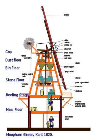
This glossary of mill machinery covers the major pieces of machinery to be found in windmills, watermills and horse mills. It does not cover machinery found in modern factories.

The Medway and its tributaries and sub-tributaries have been used for over 1,150 years as a source of power. There are over two hundred sites where the use of water power is known. These uses included corn milling, fulling, paper making, iron smelting, pumping water, making gunpowder, vegetable oil extraction, and electricity generation. Today, there is just one watermill working for trade. Those that remain have mostly been converted. Such conversions include a garage, dwellings, restaurants, museums and a wedding venue. Some watermills are mere derelict shells, lower walls or lesser remains. Of the majority, there is nothing to be seen.

<span class="mw-page-title-main">Stour watermills</span>

The River Stour has been used for centuries as a source of power. Many different processes were performed by the use of water power:- Corn milling, fulling, paper making and electricity generation. Many of the mills survive today as house conversions, with two of them still working commercially.

The Medway and its tributaries and sub-tributaries have been used for over 1,150 years as a source of power. There are over two hundred sites where the use of water power is known. These uses included corn milling, fulling, paper making, iron smelting, pumping water, making gunpowder, vegetable oil extraction, and electricity generation. Today, there is just one watermill working for trade. Those that remain have mostly been converted. Such conversions include a garage, dwellings, restaurants, museums and a wedding venue. Some watermills are mere derelict shells, lower walls or lesser remains. Of the majority, there is nothing to be seen. A large number of tributaries feed into the River Medway. The tributaries that powered watermills will be described in the order that they feed in. The mills are described in order from source to mouth. Left bank and right bank are referred to as though the reader is facing downstream. This article covers the watermills on the tributaries that feed in below Penshurst and above Yalding.

The River Medway and its tributaries and sub-tributaries have been used for more than 1,150 years as a source of power. There are over two hundred sites where the use of water power is known. Many different processes were performed by the use of water power:- corn milling, fulling, paper making, iron smelting, pumping water, making gunpowder, vegetable-oil extraction, and electricity generation. Today, there is just one watermill working for trade. Those that remain have mostly been converted. Such conversions include a garage, dwellings, restaurants, museums and a wedding venue. Some watermills are mere derelict shells, lower walls or lesser remains. Of the majority, there is nothing to be seen. A large number of tributaries feed into the River Medway. The tributaries that powered watermills will be described in the order that they feed in. The mills are described in order from source to mouth. Left bank and right bank are referred to as though the reader is facing downstream. This article deals with the watermills on the tributaries that feed in below Yalding.

<span class="mw-page-title-main">Heron Corn Mill</span>

The Heron Corn Mill is a working 18th-century water mill on the River Bela at Beetham, Cumbria, England. The mill and its mill race are Grade II* listed, and in 2013 it was awarded a £939,000 grant from the Heritage Lottery Fund for major restoration work.

<span class="mw-page-title-main">Mills on the River Wey and its tributaries</span> Watermills on the Wey in England

Many watermills lined the banks of the River Wey, England, from the 17th century due to the river's ability to provide a reliable, year-round flow of water. These mills chiefly ground wheat, often referred to as corn, for flour and oats for animal feed though many were used in the production of other goods such as paper, cloth, leather, wire and gunpowder. The river was home to more mills per mile than anywhere else in Great Britain. The mill situated at Coxes Lock near Addlestone, Surrey, is the largest. There are many mills on the river's principal tributaries, such as the Tillingbourne, the Ock and some mills on the Whitmore Vale stream, Cranleigh Waters and Hodge Brook. The last commercial mill on the Tillingbourne, Botting's Mill at Albury, closed in 1991. Headley Water Mill, on the Wey South branch is still in business. Town Mill, Guildford still has a water turbine driven generator producing electricity for the town.

References

  1. 1 2 3 4 5 6 7 8 9 Catney, Michael (2013). Survey Report: No. 27 - Patterson's Spade Mill UAS/10/05 (PDF). Ulster Archaeological Society. Retrieved 18 July 2022.
  2. 1 2 3 "Patterson's Spade Mill". Hearth Historic Buildings Trust. Retrieved 2022-07-18.
  3. Gailey, Alan (1972-01-01). "A family spade-making business in county Tyrone". Folk Life. 10 (1): 26–46. doi:10.1179/043087772798254953. ISSN   0430-8778.
  4. 1 2 3 4 5 6 Coulter, Michael D.A. (1995-11-01). "Patterson's Spade Mill, Northern Ireland". Industrial Archaeology Review. 18 (1): 96–105. doi:10.1179/iar.1995.18.1.96. ISSN   0309-0728.
  5. 1 2 "Patterson's Spade Mill, Temple Patrick, County Antrim | National Heritage Memorial Fund". www.nhmf.org.uk. Retrieved 2022-07-18.
  6. 1 2 3 4 Gallagher, Lyn (2000). Call a spade a spade: Patterson's Spade Mill, Templepatrick. National Trust. pp. 11–14.
  7. "Bushmills Foundry". www.bushmillsvillage.com. Retrieved 2022-07-18.
  8. "Patterson's Spade Mill". spab.org.uk. Retrieved 2022-07-18.
  9. "MNA124585 | National Trust Heritage Records". heritagerecords.nationaltrust.org.uk. Retrieved 2022-07-25.
  10. 1 2 3 "Spade making (forged heads)". Heritage Crafts. 2017-04-29. Retrieved 2022-07-18.
  11. Mulvihill, Mary L. (2003). Ingenious Ireland: A County-by-County Exploration of the Mysteries and Marvels of the Ingenious Irish. Simon and Schuster. ISBN   978-0-684-02094-5.
  12. Lee, Jenny (2019-01-28). "TV presenter Paul Martin on life after Flog It and how he lives and breathes antiques". The Irish News. Retrieved 2022-07-18.
  13. "171 Different Spades". The Irish Times. Retrieved 2022-07-18.
  14. Neaverson, Peter; Palmer, Marilyn (2002-01-31). Industry in the Landscape, 1700-1900. Routledge. ISBN   978-1-134-83220-0.
  15. Evans, David Morgan; Salway, Peter; Thackray, David (1996). The Remains of Distant Times: Archaeology and the National Trust. Boydell & Brewer. ISBN   978-0-85115-671-2.
  16. Palmer, Marilyn (2012-10-12). Industrial Archaeology: Principles and Practice. Routledge. ISBN   978-1-134-70508-5.
  17. Country Life. Country Life, Limited. 1993.
  18. "Patterson's Spade Mill, Templepatrick | Art UK". artuk.org. Retrieved 2022-07-25.
  19. "A View through the Window of Patterson's Spade Mill | Art UK". artuk.org. Retrieved 2022-07-25.
  20. "The Shovel Rack and Furnace, Patterson's Spade Mill, Templepatrick, Co. Antrim | Art UK". artuk.org. Retrieved 2022-07-25.
  21. "The Tilt Hammer and Guillotine, Patterson's Spade Mill, Templepatrick, Co. Antrim | Art UK". artuk.org. Retrieved 2022-07-25.
  22. "The Tail Race, Patterson's Spade Mill | Art UK". artuk.org. Retrieved 2022-07-25.
  23. Blockley, Marion; Hems, Alison; Blockley, Marion R. (2006). Heritage Interpretation. Taylor & Francis. ISBN   978-0-415-23797-0.
  24. "Ulster spade mill digs up an old wedding custom". belfasttelegraph. ISSN   0307-1235 . Retrieved 2022-07-18.
  25. "BBC Two - A Dander with Drennan, Series 1, Episode 4, Traditional music at Patterson's Spade Mill". BBC. Retrieved 2022-07-18.