
Hatton is a major town in the Nuwara Eliya District of Central Province, Sri Lanka governed by the Hatton-Dickoya Urban Council. Hatton is a major centre of the Sri Lankan tea industry.
Badulla is the capital and the largest city of Uva Province situated in the lower central hills of Sri Lanka. It is the capital city of Uva Province and the Badulla District.

Nawalapitiya is a town in Kandy District, Sri Lanka. It is governed by an Urban Council. It is 38 km (24 mi) away from Kandy and 112 km (70 mi) from Colombo, at a height of 589 m (1,932 ft) above sea level. It is located on the banks of the Mahaweli Ganga. The area was developed during the colonisation of the island by the British, as one of the colony's centres of Coffee Production.
The Sri Lanka Railway Department is Sri Lanka's railway owner and primary operator. As part of the Sri Lankan government, it is overseen by the Ministry of Transport. Founded in 1858 as the Ceylon Government Railway, it operates the nation's railways and links Colombo with other population centres and tourist destinations.
Udarata Menike is a daytime passenger train that runs between Colombo and Badulla in Sri Lanka.
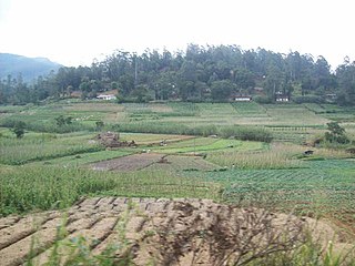
Bogahakumbura is a rural town in Sri Lanka. It is located in Badulla District of Uva Province, Sri Lanka. Majority of people in the area are involved with vegetable cultivation.

Ohiya is a rural village located in Badulla District of Uva Province, Sri Lanka. It is much closer to the Horton Plains National Park. The picturesque Colombo -Badulla Railway runs through Ohiya. Ohiya is in the Welimada Divisional Secretariat Division and the Grama Niladhari Division number is 62A.
"Podi Manike" is a Sri Lankan passenger train running from Colombo Fort to Badulla. This journey covers about 300 km and is renowned for being the most beautiful train journey in Sri Lanka, especially the stretch from Nanuoya to Ella. It takes about 10 hours to complete the journey.

Talawakelle is a town in Nuwara Eliya District in the Central Province, Sri Lanka, governed by an Urban Council. It is the center of Dimbula tea planting district, the largest tea growing area in Sri Lanka. It is situated on A7 Colombo-Nuwara Eliya highway. The altitude of Talawakelle is 1,198 metres (3,930 ft). Talawakelle railway station is one of the major stops of Udarata or Main railway line. The town is administrated by Talawakelle-Lindula urban council.
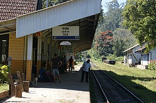
Ella is a small town in the Badulla District of Uva Province, Sri Lanka governed by an Urban Council. It is approximately 200 kilometres (120 mi) east of Colombo and is situated at an elevation of 1,041 metres (3,415 ft) above sea level. The area has a rich bio-diversity, dense with numerous varieties of flora and fauna. Ella is surrounded by hills covered with cloud forests and tea plantations. The town has a cooler climate than surrounding lowlands, due to its elevation. The Ella Gap allows views across the southern plains of Sri Lanka.

Pattipola railway station is the 66th station on the Main Line, and is 226.8 km (140.9 mi) away from Colombo. It is the highest railway station in Sri Lanka with an elevation of 1,897.5 m (6,225 ft) high above mean sea level. The station has one platform with a second track as a siding loop. All the trains that run on the Main Line, including the Podi Menike and Udarata Menike express trains stop at the station.
Matale Railway Station is the terminus railway station on the Matale railway line of Sri Lanka. It is the 65th railway station on the line from Colombo Fort railway station and is located in the Matale District in the Central Province. It is 148.6 kilometres (92.3 mi) from the Colombo Fort Railway Station and 27.64 kilometres (17.17 mi) from the Kandy Railway Station. The station was opened on 14 October 1880 following the construction of a branch line from Kandy to Matale.
Colombo - Badulla Night Mail Train is a night time passenger and mail train that runs between Colombo and Badulla in Sri Lanka.
Pattipola Railway Tunnel, or the Summit Tunnel, is the third longest and the highest railway tunnel in Sri Lanka. It is located approximately 3 km (1.9 mi) away from the Pattipola railway station, straddling the boundary of the Badulla and Nuwara Eliya Districts.

Polgahawela Junction railway station is a major junction station, situated in the Kurunegala District, North Western Province, Sri Lanka. It is the 34th railway station on the Main line and is 73.83 kilometres (45.88 mi) away from the Colombo Fort Railway Station, at an elevation of 74.39 metres (244.1 ft) above sea level. The station is located at the centre of Polgahawela and is a main junction point joining two railway lines; one coming from the upcountry of Sri Lanka and another from the northern part of the country.
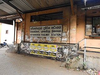
Veyangoda railway station is a railway station in the Western Province, Sri Lanka. The station is served by Sri Lanka Railways, which is the state-run railway operator.
Haputale Railway Station is the 69th station on the Main Line. The station is located between Idalgashinna and Diyatalawa railway stations in Badulla District, Uva Province. It is located 247.97 km (154.08 mi) from Colombo Fort railway station at an elevation of 1,479.57 m (4,854.2 ft) above sea level.
Dodanduwa is a small coastal town situated in Galle District, Southern Province of Sri Lanka.
Ukuwela Railway Station is a railway station on the Matale railway line of Sri Lanka. It is the 65th railway station on the line from Colombo Fort railway station and is located in the Matale District in the Central Province. It is 141.6 kilometres (88.0 mi) from the Colombo Fort Railway Station and 28 km (17 mi) from the Kandy Railway Station. The station was opened on 14 October 1880 following the construction of a branch line from Kandy to Matale.

