
Chandrapur district is a district in the Nagpur Division in the Indian state of Maharashtra. Chandrapur was the largest district in India until the Gadchiroli and Sironcha tehsils were separated as Gadchiroli district in 1981. In 2011, the district population was 2,204,307.

Bhandara District is an administrative district in the state of Maharashtra in India. The district headquarters are located at Bhandara. The district occupies an area of 3717 km2 and has a population of 1,200,334, of which 19.48% are urban as of 2011. The growth rate of Bhandara is 5.56% Bhandara has a mixed economy with agriculture, industries and forest resources. Bhandara is known for its large production of rice. Tumsar, a tahsil town, is a noted rice market. Bhandara town is also known as "Brass City" owing to the presence of a large brass products industry. Bhandara has several tourist destinations, like Ambagad Fort, Brahmi, Chinchgad, and Dighori.

Gondia district is an administrative district in the state of Maharashtra in India. The district headquarter is located at Gondia. The district occupies an area of 5,234 km2 (2,021 sq mi) and has a population of 1,322,507 of which 11.95% were urban. The district is part of Nagpur Division. There are 8 Talukas in Gondia District. Gondia Airport is second airport in Vidharbha region and serves city of Gondia.
Bhandara is a city and municipal council which serves the administrative headquarters of eponymous administrative Bhandara Taluka and Bhandara district in the state of Maharashtra, India. It is connected with NH-53 and NH-247.
Kinwat is a city which falls under the municipal council of the Nanded District, in the Indian state of Maharashtra. The Kinwat Taluka came into existence in 1905 when a number of villages from Narsapur,Tamsi, and Nirmal Talukas from the Adilabad District, were combined. Earlier, these villages were under the Hyderabad Division. In 2011, Kinwat had population of 28454 with literacy rate of 82% and female sex ratio of 929. Kinwat is 125 km away from Nanded city. Kinwat has Rural Hospital.
Pauni is a town and a Municipal Council in Bhandara district in the Indian state of Maharashtra. Now it has National Highway NH-247. Pauni is also known as Kashi of Vidarbha due to its wide swath of temples.
Lakhandur is a City and headquarter of Lakhandur Taluka in Bhandara district of Maharashtra, India. It is connected with National Highway NH-353C.It was Vidhan Sabha Constituency till 2009. It is located in vidharbha region of Maharashtra.It is located on bank of chulbandh river.
Peth or Peint is the smallest tehsil of Nashik subdivision of Nashik district in Maharashtra, India. It belongs to Northern Maharashtra region. It belongs to Nashik Division. Peth is a Taluka headquarter. It is located 54 km to the West of Nashik District headquarters. It is also called as Peint. Pin code of Peth is 422208 and postal head office is Peth.
Bhandara Lok Sabha constituency was a former Lok Sabha (parliamentary) constituency in Maharashtra state in western India. With the delimitation of the parliamentary constituencies in 2008, based on the recommendations of the Delimitation Commission of India constituted in 2002, this constituency ceased to exist. A new constituency, Bhandara-Gondiya came into existence in place of it.
Kadegaon is a village and taluka of Sangli district of Maharashtra in India.
Adyar or Adyal is a village of Pauni Taluka in Bhandara district in the Indian state of Maharashtra. It is connected with National Highway NH 247.
Bhandara Assembly constituency is one of the 288 Vidhan Sabha constituencies in Maharashtra state in central India. This constituency is one of the three constituencies located in Bhandara district.
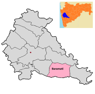
Baramati taluka is a taluka in Baramati subdivision of Pune district of state of Maharashtra in India.

Purandar taluka is a taluka of Pune district of state of Maharashtra in India. There are 108 villages and 3 towns in Purandhar Taluka.

The Kolar River is a river of Nagpur district, Maharashtra, India, flowing southeast from above the town of Saoner to its juncture with the Kanhan River. It is in the Godavari river basin. The Kolar River forms the boundary between Saoner taluka and Ramtek taluka.
Lakhandur Taluka is a Taluka in Sakoli subdivision of Bhandara district in Maharashtra State of India.
Sakoli Taluka, is a Taluka in Sakoli subdivision of Bhandara district in Maharashtra State of India.
Lakhani Taluka, is a Taluka in Sakoli subdivision of Bhandara district in Maharashtra State of India. The seat is the city of Lakhani.
Shivnala (Gondi) is a small village of Pauni Taluka in Bhandara district of Maharashtra, India. The special thing about this village is that people of all the tribal castes reside here, hence the name of this village was Shivnala (Gondi).

