Related Research Articles

Montgomery County is a rural county located in the southern Piedmont of the U.S. state of North Carolina. As of the 2020 census, the population was 25,751. Its county seat is Troy.
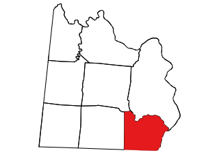
Marlboro County is a county located in the Pee Dee region on the northern border of the U.S. state of South Carolina. As of the 2020 census, its population was 26,667. Its county seat is Bennettsville. The Great Pee Dee River runs through it. Marlboro County comprises the Bennettsville, SC Micropolitan Statistical Area.

Dillon County is a county located in the U.S. state of South Carolina. As of the 2020 census, the county's population was 28,292. The county seat is Dillon.

Stanly County is a county in the U.S. state of North Carolina. As of the 2020 census, the population was 62,504. Its county seat is Albemarle.

Society Hill is a town in Darlington County, South Carolina, United States alongside the Pee Dee River. It is the oldest community in Darlington County and one of the first towns founded in South Carolina. The town was once the intellectual center of the Pee Dee region. However, the town's fortunes declined in the 19th century after rivers became less important as means of transportation. It is part of the Florence Metropolitan Statistical Area.
Marion is a city in and the county seat of Marion County, South Carolina, United States. It is named for Francis Marion, a brigadier general from South Carolina in the American Revolutionary War. The population was 6,939 at the 2010 census.
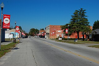
McColl is a town in Marlboro County, South Carolina, United States. It lies in the state's Pee Dee region, 8 miles (13 km) from the North Carolina border. The population was 2,174 at the 2010 census.

The Waccamaw River is a river, approximately 140 miles (225 km) long, in southeastern North Carolina and eastern South Carolina in the United States. It drains an area of approximately 1,110 square miles (2886 km²) in the coastal plain along the eastern border between the two states into the Atlantic Ocean. Along its upper course, it is a slow-moving, blackwater river surrounded by vast wetlands, passable only by shallow-draft watercraft such as canoe. Along its lower course, it is lined by sandy banks and old plantation houses, providing an important navigation channel with a unique geography, flowing roughly parallel to the coast.
The Little Pee Dee River is a 116-mile-long (187 km) tributary of the Pee Dee River. The Little Pee Dee technically arises near Laurinburg, North Carolina as Gum Swamp, which flows southward, receiving several small tributaries, across the South Carolina border into Red Bluff Lake, near McColl, South Carolina. The lake is at an elevation of 135 feet (41 m) above sea level, and from the outlet of the lake, the flow is called the Little Pee Dee River. The Little Pee Dee River is named after the Pee Dee Indian Tribe. Today, the tribe still occupies some of the land, although the tribe only consists of just over 200 enrolled members.
The Pee Dee is a region in the northeast corner of the U.S. state of South Carolina. It lies along the lower watershed of the Pee Dee River, which was named after the Pee Dee, an Indigenous tribe historically inhabiting the region.
Edmund DeBerry was a U.S. Congressman from North Carolina, from 1829 to 1831, from 1833 to 1845 and from 1849 to 1851.

Florence Regional Airport is three miles east of Florence, in Florence County, South Carolina.

The Lumber River, sometimes referred to as the Lumbee River, is a 133-mile-long (214 km) river in south-central North Carolina in the flat Coastal Plain. European settlers first called the river Drowning Creek, which is still used as the name of its headwater. The waterway known as the Lumber River extends downstream from the Scotland County-Hoke County border to the North Carolina-South Carolina border. Soon after crossing into South Carolina, the Lumber River flows into the Little Pee Dee River, which flows into the Pee Dee River, or Great Pee Dee River. Finally, the combined waters flow into Winyah Bay and the Atlantic Ocean.

South Carolina's 7th congressional district is a congressional district for the United States House of Representatives in South Carolina, established in 2011 following apportionment of another seat to the state in the redistricting cycle following the 2010 census. It is located in the Pee Dee region, and includes all of Chesterfield, Darlington, Dillon, Georgetown, Horry, Marion, and Marlboro Counties and most of Florence County. The district is represented by Republican Russell Fry who was elected in 2022 and took office on January 3, 2023.
Blewett Falls Lake is a reservoir located in Anson and Richmond counties in the U.S. state of North Carolina. No bridges span the lake. It is a major lake in the Uwharrie Lakes Region and the southernmost and widest body in this chain of lakes. Created by the damming of the Great Pee Dee River, the lake occupies the former Blewett Falls on that river, which were named after an early local family. The lake was created for hydropower in the early 20th century.

Town Creek Indian Mound is a prehistoric Native American archaeological site located near present-day Mount Gilead, Montgomery County, North Carolina, in the United States. The site, whose main features are a platform mound with a surrounding village and wooden defensive palisade, was built by the Pee Dee, a South Appalachian Mississippian culture people that developed in the region as early as 980 CE. They thrived in the Pee Dee River region of North and South Carolina during the Pre-Columbian era. The Town Creek site was an important ceremonial site occupied from about 1150—1400 CE. It was abandoned for unknown reasons. It is the only ceremonial mound and village center of the Pee Dee located within North Carolina.
Pee Dee, also known as Pee Dee Station, is a populated place in Anson County, North Carolina, United States, situated at an elevation of 236 feet (72 m) AMSL. It is a former railway stop for passengers traveling on the Seaboard Air Line Railroad. Pee Dee is southeast of Lilesville, at the intersection of North Carolina Highway 74 and North Carolina Highway 145. The community was named after the Pee Dee River.

Biscoe Township, population 5,765, is one of eleven townships in Montgomery County, North Carolina, United States. Biscoe Township is 47.97 square miles (124.2 km2) in size and is located in the east central part of the county. The Towns of Biscoe and Candor are located in this township.

Cheek Creek Township, population 628, is one of eleven townships in Montgomery County, North Carolina, United States. Cheek Creek Township is 35.03 square miles (90.7 km2) in size and is located in the south-central part of the county.
Morven Township, population 2,065, is one of eight townships in Anson County, North Carolina, United States. Morven Township is 48.39 square miles (125.3 km2) in size and located in southeastern Anson County. Morven Township contains the towns of Morven and McFarlan within it.
References
- ↑ "Pee Dee". Geographic Names Information System . United States Geological Survey, United States Department of the Interior.
- ↑ Montgomery County, North Carolina (Map). North Carolina Department of Transportation.
- ↑ "DEBERRY, Edmund". Biographical Directory of the United States Congress. Retrieved October 17, 2011.
Municipalities and communities of Montgomery County, North Carolina, United States | ||
|---|---|---|
| Towns |  | |
| Unincorporated communities | ||
34°56′07″N79°53′22″W / 34.9351537°N 79.8895028°W