Related Research Articles

Albury is a major regional city that is located in the Murray region of New South Wales, Australia. It is part of the twin city of Albury-Wodonga and is located on the Hume Highway and the northern side of the Murray River. Albury is the seat of local government for the council area which also bears the city's name – the City of Albury. It is on the Victoria–New South Wales border.

Tailem Bend is a rural town in South Australia, 85 kilometres south-east of the state capital of Adelaide. It is located on the lower reaches of the River Murray, near where the river flows into Lake Alexandrina. It is linear in layout since it is constrained by river cliffs on its western side and the Adelaide–Melbourne railway line is dominant on its eastern side. The town grew and consolidated through being a large railway centre between the 1890s and 1990s; now it continues to service regional rural communities. In the 2021 census, Tailem Bend and the surrounding area had a population of 1,705.
The Overland is an interstate passenger train service in Australia, travelling between the state capitals of Melbourne and Adelaide, a distance of 828 km (515 mi). It first ran in 1887 as the Adelaide Express, known by South Australians as the Melbourne Express. It was given its current name in 1936. Now operated by private company Journey Beyond, the train undertakes two return trips a week. Originally an overnight train that stopped at large intermediate stations, it now operates during the day, stopping less frequently.

Rail transport in the Australian state of South Australia is provided by a number of railway operators who operate over the government-owned railway lines. The network consists of 1435 mm standard gauge links to other states, the 1600 mm broad gauge suburban railways in Adelaide, a freight-only branch from Dry Creek to Port Adelaide and Pelican Point, a narrow-gauge gypsum haulage line on the Eyre Peninsula, and both copper–gold concentrate and coal on the standard-gauge line in the Adelaide–Darwin rail corridor north of Tarcoola.
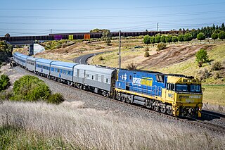
The North East railway line is a railway line in Victoria, Australia. The line runs from Southern Cross railway station on the western edge of the Melbourne central business district to Albury railway station in the border settlement of Albury-Wodonga, serving the cities of Wangaratta and Seymour, and smaller towns in northeastern Victoria.

The Piangil railway line is a 5 ft 3 in gauge railway line in north-western Victoria, Australia. It branches off the Deniliquin line just north of Bendigo, and runs in a north-westerly direction through Pyramid Hill and Kerang to the border town of Swan Hill, then roughly parallels the New South Wales border to Piangil and Yungera. The line is now open only as far as Piangil, and passenger services only operate to Swan Hill.
The Deniliquin railway line is a broad-gauge railway line serving north-western Victoria, Australia. The line runs from the New South Wales town of Deniliquin into Bendigo, before turning south-south-east towards Melbourne, terminating in Docklands near the central business district. It is a major trunk line both for passenger and freight trains, with many lines branching off from it.
The Mildura railway line is a heavy rail line in northwestern Victoria, Australia. The line runs from Yelta station to Ballarat station via the settlements of Mildura, Ouyen and Maryborough in an approximate south-southeasterly direction. Initial sections of the line opened from Ballarat in 1874 and the line reached Mildura in 1903.

Meringur is a locality to the west of Mildura in northwestern Victoria, Australia. At the 2016 census, Meringur and the surrounding area had a population of 67 down from 128 in 2011. It is located in the Millewa region at the end of the Red Cliffs-Meringur Road towards the South Australian border.
Marama is a town and a locality in the Australian state of South Australia located in the state's south-east about 146 kilometres (91 mi) east of the state capital of Adelaide and about 28 kilometres (17 mi) east of the municipal seat of Karoonda.
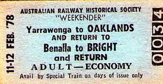
The Oaklands railway line is a freight-only railway line in north-eastern Victoria, Australia. The line branches from the main North East railway at Benalla station and runs across the Victoria-New South Wales border to the town of Oaklands, New South Wales.
The Bright railway line was a railway line in Victoria, Australia constructed by the Victorian Railways as a branch from the previously constructed Yackandandah line to Beechworth, with the Bright line branching at Everton. The line followed the Ovens Valley opening as far as Myrtleford on 17 December 1883 being extended to Bright on 17 October 1890.

Peebinga Conservation Park is a 34 km2 protected area lying 40 km north of the town of Pinnaroo in the Murray Mallee region of south-eastern South Australia, about 240 km east of Adelaide and 10 km west of the Victorian border.

The Morkalla railway line was a railway in the Millewa region of north-western Victoria, Australia. It extended west from Red Cliffs railway station on the Mildura railway line into wheat farming areas established as soldier settlements after World War I.
The Peebinga railway line was a railway line in the South Australian Railways network. It opened on 18 December 1914, originating from a junction with the Barmera line at Karoonda. The line extended eastward through the Murray Mallee region, ultimately terminating at Peebinga, located just two kilometres from the Victorian state border. The railway was officially closed on 7 December 1990.
Peebinga is a town and locality in the Australian state of South Australia. Peebinga was the terminus of the Peebinga railway line which was built in 1914 as part of a major state government project to open up the Murray Mallee for grazing and cropping.

The Waikerie railway line was a railway line on the South Australian Railways network.

Tailem Bend railway station is located on the Adelaide-Wolseley line in Tailem Bend, South Australia. It is also the junction point for the Loxton and Pinnaroo lines.

The Mount Gambier railway line is a closed railway line in South Australia. Opened in stages from 1881, it was built to narrow gauge and joined Mount Gambier railway station, which was at that time the eastern terminus of a line to Beachport. It connected at Naracoorte to another isolated narrow gauge line joining Naracoorte to Kingston SE, and to the broad gauge Adelaide-Wolseley line at Wolseley, at around the same time that was extended to Serviceton to become the South Australian part of the interstate Melbourne–Adelaide railway. It was closed in April 1995.
Kringin is a town and a locality in the Australian state of South Australia located in the state’s east about 199 kilometres (124 mi) east of the state capital of Adelaide and about 61 kilometres (38 mi) south of the municipal seat of Loxton.
References
- ↑ Murray Railways Waikerie line recommended 21 September 1912
- ↑ Peebinga Railway Station 28 February 1919
- ↑ "The Man on the Land". The Argus . Melbourne: National Library of Australia. 24 August 1928. p. 16. Retrieved 16 January 2015.
- ↑ RTA Group Peebinga
- ↑ Quinlan, Howard; Newland, John (2000). Australian Railway Routes 1854 - 2000. Redfern: Australian Railway Historical Society. p. 55. ISBN 0-909650-49-7.
- ↑ Bromby, Robin (2006). Ghost Railways of Australia. Sydney: Lothian Books. pp. 74–75. ISBN 0-7344-0923-0.