
The first railway in colonial South Australia was a line from the port of Goolwa on the River Murray to an ocean harbour at Port Elliot, which first operated in December 1853, before its completion in May 1854.
Lameroo is a town in the Murray Mallee region of South Australia. It is on the Mallee Highway and Pinnaroo railway line about 40 km west of the Victorian border, or 210 km east of Adelaide. It is primarily a service town for the surrounding rural areas, growing grain and sheep. Lameroo now includes the former settlements of Kulkami, Mulpata, Wirha and Gurrai, which were on the Peebinga railway line, and Wilkawatt, which was between Parrakie and Lameroo on the Pinnaroo railway.

Mount Torrens is a small town in the eastern Adelaide Hills region of South Australia, 46 kilometres east-north-east of the state capital, Adelaide and 8 kilometres east of Lobethal. It is on Onkaparinga Valley Road (B34) between the towns of Charleston and Birdwood. It is the eastern end of the Amy Gillett Bikeway, which follows the former railway alignment from Oakbank. Mount Torrens is within the jurisdiction of the Adelaide Hills Council and the Mid Murray Council.
Marama is a town and a locality in the Australian state of South Australia located in the state's south-east about 146 kilometres (91 mi) east of the state capital of Adelaide and about 28 kilometres (17 mi) east of the municipal seat of Karoonda.
The Adelaide–Wolseley railway line is a 313 kilometre line running from Adelaide to Wolseley on the Australian Rail Track Corporation network. It is the South Australian section of the Melbourne–Adelaide railway.

Wanbi is a township on the Karoonda Highway in the Australian state of South Australia, about 160 kilometres (99 mi) east of the state capital of Adelaide and about 56 kilometres (35 mi) north-east of the municipal seat of Karoonda. Situated on a ridgeline covered by mallee trees, it has a one-street layout common to many South Australian townships. A hotel, advertised as being "in the heart of the scrub, stumps and sand", was built in 1932, when commercial activity was increasing and a general store, cream depot and several houses – most housing South Australian Railways employees – were present.

The Pinnaroo railway line was a railway line on the South Australian Railways network. It ran east from the Adelaide to Melbourne line at Tailem Bend to Pinnaroo near the South Australia / Victoria state border. The route continues into Victoria via the Victorian Railways line to Ouyen, where it joined the Mildura line.

The Loxton railway line is a closed railway line in the northern Murray Mallee region of South Australia. It ran north-east from Tailem Bend to grain silos near Loxton.

The Yinkanie railway line was a 50.6 kilometres (31.4 mi) railway line on the South Australian Railways network. Named the Wanbi to Moorook Railway in its enabling Act, it never reached its intended destination on the River Murray. The railway ran from a junction with the Barmera line at Wanbi northwards to Yinkanie, opening on 7 September 1925 and closing on 1 May 1971.
The Barmera railway line was the second railway built to develop the Murray Mallee region of South Australia, in 1913. It followed the success of the Pinnaroo railway line in 1906. Both lines branched east from Tailem Bend to the north of the main Melbourne–Adelaide railway. The Brown's Well line was the more northerly, and extended into country which had not been developed much before the railway, partly due to the absence of any viable transport route for produce. The original terminus of the Brown's Well railway was at Meribah, not far from the Victorian border.

The Waikerie railway line was a railway line on the South Australian Railways network.

Monarto South railway station was located on the Adelaide to Wolseley line serving the South Australian town of Monarto South.
The Hamley Bridge–Gladstone railway line was a railway line on the South Australian Railways network. It extended from a junction at Hamley Bridge on the Roseworthy-Peterborough line through Balaklava and Brinkworth to Gladstone.
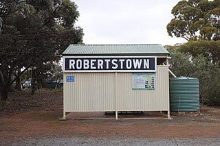
The Robertstown railway line was a railway line on the South Australian Railways network. It opened on 9 December 1914 from a junction with the Morgan line at Eudunda running 21.6 kilometres via Point Pass to Robertstown. The line was used by both passenger and freight trains, though the regular passenger service on the line was withdrawn on 23 September 1962. Grain trains serving the Robertstown silos were among the last traffic to use the line in its later years. Train Tour Promotions ran the last passenger train using locomotive 804 on 20 May 1989, with the last freight train being a grain train on 21 February 1990. The line formally closed on 25 September 1990. The line was lifted in the years following, with all stations on the line being demolished. The only significant railway remnants left are the former Robertstown station sign and the former goods crane. The goods crane has collapsed, though there are plans to restore it.

Coomandook railway station was located in the town of Coomandook, about 153 kilometres from Adelaide station.

Coonalpyn railway station is located on the Adelaide-Wolseley line in Coonalpyn, South Australia.

Tintinara railway station is located on the Adelaide-Wolseley line in Tintinara, South Australia.

Keith railway station was located on the Adelaide-Wolseley line in Keith, South Australia.
Lameroo railway station was located on the Pinnaroo railway line. It served the town of Lameroo, South Australia.
