Chowilla Dam

Last updated

Chowilla Dam
Australia South Australia relief location map.png
Red pog.svg
Location of the proposed Chowilla Dam
CountryAustralia
Location60 kilometres (37 mi) upstream of Renmark, South Australia
Coordinates 33°58′15.6″S140°53′41.1″E / 33.971000°S 140.894750°E / -33.971000; 140.894750 Coordinates: 33°58′15.6″S140°53′41.1″E / 33.971000°S 140.894750°E / -33.971000; 140.894750
StatusCancelled
Construction began1963 (1963)
Demolition date1970
Construction costA$68 million
Dam and spillways
Type of dam Embankment dam
Impounds Murray River
Height (foundation)41 feet (12 m)
Length3.3 miles (5.3 km)
Spillways 18 [1]
Reservoir
Surface area1372 km2
Maximum length55 miles (89 km)
Maximum width20 miles (32 km)
Maximum water depth55 feet (17 m)

Chowilla Dam was a proposed water storage reservoir on the Murray River in the 1960s. The dam wall would have been in South Australia, but the reservoir behind it would have stretched upstream into Victoria and New South Wales. The site was selected in 1960. Early preparations for its construction were conducted before the project was halted. These included a 23 km service railway from the Barmera railway line, which was dismantled without ever actually being used.

Contents

Purpose

The dam was proposed to provide flood regulation and reliable water supplies for South Australia, which pumps water from the lower Murray through pipelines across the Mount Lofty Ranges to Adelaide, and parts of the Mid North, Yorke Peninsula and Eyre Peninsula. It was announced on 21 April 1960 by Tom Playford, the Premier of South Australia. [1]

Cross border agreement

It had been agreed by the River Murray Commission in September 1961 and governments of South Australia, Victoria, New South Wales and Australia in 1963. [2] A preliminary meeting was held on 16 April 1962 to start discussion on Chowilla Dam. Participants in that meeting were Prime Minister of Australia Bob Menzies, Premier of South Australia Tom Playford, Premier of Victoria, Deputy Premier of New South Wales and Minister for Development Jack Renshaw, Treasurer of Australia Harold Holt, Minister for National Development Bill Spooner. [3] The follow-up meeting at which an agreement was reached was held on 19 November 1962. Participants were Spooner (also President of the River Murray Commission) and Menzies for the Commonwealth, Renshaw and George Enticknap for NSW, Premier of Victoria Henry Bolte and Premier of South Australia Thomas Playford. The four governments would share the costs evenly, however the Commonwealth would extend a loan for the New South Wales component in exchange for water from the Menindee Lakes during construction. [4]

Reservoir

The reservoir would have been 55 miles (89 km) long and up to 20 miles (32 km) wide with a surface area of 530 square miles (1,400 km2) due to the flat terrain. The dam wall would have been 18,000 feet (5,500 m) long and the reservoir depth up to 55 feet (17 m) with a capacity of 5.06 million acre feet (6,240  Gl ). [2] The reservoir would have been approximately 45 square miles (120 km2) in South Australia, 160 square miles (410 km2) in Victoria and 195 square miles (510 km2) in New South Wales. [1]

Engineering

The dam was proposed to be an earth embankment up to 50 feet (15 m) high and 18,000 feet (5,500 m) long. It would include a concrete spillway 800 feet (240 m) long and a navigation lock. The lock was removed to save cost in later versions of the plans before the project was cancelled. The embankment would block the Murray River and both Chowilla Creek and Monoman Creek in the Chowilla floodplain. Most of both the impervious core and the compacted sand shoulders of the dam embankment would be sourced from local materials of specific layers of soil. There would also be an 80 foot (24 m) deep cut-off wall under the concrete spillway and lock to reduce seepage. [5]

The plan to deal with the highly saline groundwater was to drill relief wells and drains, and pump it to evaporation ponds several miles away. [5] This is similar to what has been done more recently at several points along the Murray for what are now known as "salt interception schemes". Rock would need to be transported from further away to provide protective riprap, filters, and aggregate in concrete and bituminous membrane. This would be transported by rail from 150 miles (240 km) away.

The South Australian Railways were engaged to transport the rock that was required. A 27.3 kilometres (17.0 mi) railway line was built, branching from the Barmera line eight kilometres north of Yamba. [6] Sixty FCD-class flatcars were constructed by Islington Railway Workshops to carry skips that could be taken off the train by crane to move the rock to where it was required. A siding near Kinchina Quarry between Murray Bridge and Monarto South was built to collect the stone. When the project was cancelled, the line had been completed except for laying of ballast and the terminal siding. [7] [8] Work to remove the line began in September 1972, with the track used to upgrade the Waikerie line. [9] [10]

Controversy

The dam and reservoir would have flooded the wetlands in what is now the Chowilla Game Reserve, Chowilla Regional Reserve and northern edge of the Murray-Sunset National Park and potentially raised salinity in the Riverland and lower Murray as the reservoir would have been quite shallow in a hot dry climate.

The dam was first proposed and announced by Tom Playford, the Liberal and Country League premier of South Australia in 1960. Playford's government had been in office since 1938, and through that time had presided over significant economic and infrastructure development in the state. This had included encouraging new industries, establishing satellite cities around Adelaide, nationalising the electricity generators and stimulating self-sufficiency by using Leigh Creek brown coal instead of importing black coal from interstate. The Chowilla Dam would have continued this theme by providing greater certainty and control over water supplies as Adelaide's water requirements were increasing.

Playford and the LCL won the 1962 state election only with the support of independent Tom Stott in an otherwise-hung parliament. Stott was a strong supporter of building the dam, which would be in his electorate. The Frank Walsh-led Australian Labor Party won the 1965 election. After leadership changes in both parties, the LCL led by Steele Hall defeated the ALP led by Don Dunstan in the 1968 election again through the support of Stott.

Hall became convinced that the Chowilla Dam was not a good idea and favoured agreements for water supply from Dartmouth Dam instead. This was due to a combination of the increasing cost estimates of building the dam, and the increasing awareness of the environmental impacts of the proposed dam. [11] As Stott still believed that the dam would be valuable in his electorate, and with local community opinion mostly in its favour, he switched his support from Hall to Dunstan (who supported both Chowilla and Dartmouth Dams), resulting in the 1970 election which returned the ALP with a majority to govern in its own right (27 out of 47 seats). [12]

Chowilla was one of the first instances of a campaign in which there was strong advocacy for environmental protection. [11] The Sunraysia Salinity Committee opposed the dam as it believed that the combination of high evaporation and saline groundwater would lead to increased salinity downstream which would be harmful to horticulture. [13] The future salinity concerns were raised in contrast to the local economic benefits to be brought by the construction project. The Victorian government was the first to change from support to opposition of the project. [14]

Cancellation

The Dartmouth Dam was built on the Mitta Mitta River (a tributary of the Murray) in the 1970s. There are agreements in place to assure South Australia of a supply of water, and management to control the flow, because it takes six weeks for water from Dartmouth Dam to reach South Australia. Lake Victoria in southwestern New South Wales, on an anabranch of the Murray, provides closer guaranteed supply and is operated by South Australian water authorities. [2]

Related Research Articles

Murray River Longest river in Australia

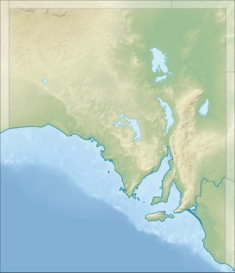
The Murray River is Australia's longest river, at 2,508 kilometres (1,558 mi) in length. The Murray rises in the Australian Alps, draining the western side of Australia's highest mountains, and then meanders across Australia's inland plains, forming the border between the states of New South Wales and Victoria as it flows to the northwest into South Australia. It turns south at Morgan for its final 315 kilometres (196 mi), reaching the ocean at Lake Alexandrina.

Dartmouth Dam Dam in Victoria

Dartmouth Dam is a large rock-fill embankment dam with an uncontrolled chute spillway across the Mitta Mitta, Gibbo, and Dart rivers, the Morass Creek and a number of small tributaries. The dam is located near Mount Bogong in the north-east of the Australian state of Victoria. The dam's purpose includes irrigation, the generation of hydro-electric power, water supply and conservation. The impounded reservoir is called Dartmouth Reservoir, sometimes called Lake Dartmouth. The Dartmouth Power Station, a hydro-electric power station that generates power to the national grid, is located near the dam wall.

Snowy Mountains Scheme Dam in Kosciuszko National Park, New South Wales

The Snowy Mountains scheme or Snowy scheme is a hydroelectricity and irrigation complex in south-east Australia. The Scheme consists of sixteen major dams; seven power stations; one pumping station; and 225 kilometres (140 mi) of tunnels, pipelines and aqueducts that were constructed between 1949 and 1974. The Scheme was completed under the supervision of Chief Engineer, Sir William Hudson. It is the largest engineering project undertaken in Australia.

Hume Dam Dam in Riverina, New South Wales

Hume Dam, formerly the Hume Weir, is a major dam across the Murray River downstream of its junction with the Mitta River in the Riverina region of New South Wales, Australia. The dam's purpose includes flood mitigation, hydro-power, irrigation, water supply and conservation. The impounded reservoir is called Lake Hume, formerly the Hume Reservoir. It is a gated concrete gravity dam with four earth embankments and twenty-nine vertical undershot gated concrete overflow spillways.

Murray–Darling basin largest drainage basin of Australia

The Murray–Darling basin is a large geographical area in the interior of southeastern Australia. Its name is derived from its two major rivers, the Murray River and the Darling River. The basin, which drains around one-seventh of the Australian land mass, is one of the most significant agricultural areas in Australia. It spans most of the states of New South Wales and Victoria, the Australian Capital Territory, and parts of the states of Queensland and South Australia. The basin is 3,375 kilometres (2,097 mi) in length, with the Murray River being 2,508 km (1,558 mi) long.

Wyangala Dam Dam in New South Wales, Australia

Wyangala Dam is a major gated rock fill with clay core embankment and gravity dam with eight radial gates and a concrete chute spillway across the Lachlan River, located in the south-western slopes region of New South Wales, Australia. The dam's purpose includes flood mitigation, hydro-power, irrigation, water supply and conservation. The impounded reservoir is called Lake Wyangala.

Tom Stott Australian politician

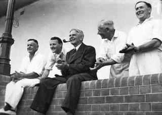
Tom Cleave Stott CBE spent 37 years as an independent member of the South Australian House of Assembly, from 1933 to 1970. He served as Speaker of the House from 1962 to 1965 for the Tom Playford LCL government and 1968 to 1970 for the Steele Hall LCL government, both times in exchange for his confidence and supply vote to form minority governments.

Thomas Playford IV 20th-century Australian politician and fruit grower

Sir Thomas Playford was an Australian politician from the state of South Australia. He served continuously as Premier of South Australia and leader of the Liberal and Country League from 5 November 1938 to 10 March 1965. Though controversial, it was the longest term of any elected government leader in Australian history. His tenure as premier was marked by a period of population and economic growth unmatched by any other Australian state. He was known for his parochial style in pushing South Australia's interests, and was known for his ability to secure a disproportionate share of federal funding for the state as well as his shameless haranguing of federal leaders. His string of election wins was enabled by a system of a malapportionment gerrymander that bore his name, the 'Playmander' − which saw the Labor Party win clear majorities of the statewide two-party vote whilst failing to form government in 1944, 1953, 1962 and 1968.

1970 South Australian state election South Australian general election held in 1970

State elections were held in South Australia on 30 May 1970. All 47 seats in the South Australian House of Assembly were up for election. The incumbent Liberal and Country League led by Premier of South Australia Steele Hall was defeated by the Australian Labor Party led by Leader of the Opposition Don Dunstan.

1968 South Australian state election South Australian general election held in 1968

The 1968South AustralianState election was held in South Australia on 2 March 1968. All 39 seats in the South Australian House of Assembly were up for election; 38 of the 39 contests were won by candidates from Australia's two major political parties. The incumbent Australian Labor Party and the Liberal and Country League both won 19 seats. The sole independent candidate to win a race, Tom Stott of the Ridley electorate, joined with the LCL's 19 seats to form a coalition government that held a 20 to 19 majority, thus defeating the Dunstan Labor government.

Irrigation in Australia

Irrigation is a widespread practice required in many areas of Australia, the driest inhabited continent, to supplement low rainfall with water from other sources to assist in growing crops and pasture. Overuse or poor management of irrigation is held responsible by some for environmental problems such as soil salinity and loss of habitat for native flora and fauna.

Cairn Curran reservoir is situated along the Loddon River near the townships of Baringhup, Newstead and Welshmans Reef in Victoria, Australia. Constructed between 1947 and 1956.

Bear River (Feather River tributary) River in California, United States

The Bear River is a tributary of the Feather River in the Sierra Nevada, winding through four California counties: Yuba, Sutter, Placer, and Nevada. About 73 miles (117 km) long, the river flows generally southwest through the Sierra then west through the Central Valley, draining a narrow, rugged watershed of 295 square miles (760 km2).

Los Vaqueros Reservoir

The Los Vaqueros Reservoir is located in the northern Diablo Range, within northeastern Contra Costa County, northern California. It was completed by the Contra Costa Water District (CCWD) in 1998 to improve the quality of drinking water for its 550,000 customers in Central and Eastern Contra Costa County, and the reservoir is accessible via Vasco Road, a road which connects Brentwood and Livermore.

As Australia's supply of freshwater is increasingly vulnerable to droughts, possibly as a result of climate change, there is an emphasis on water conservation and various regions have imposed restrictions on the use of water.

The Barmera railway line was the second railway built to develop the Murray Mallee region of South Australia, in 1913. It followed the success of the Pinnaroo railway line in 1906. Both lines branched east from Tailem Bend to the north of the main Melbourne–Adelaide railway. The Brown's Well line was the more northerly, and extended into country which had not been developed much before the railway, partly due to the absence of any viable transport route for produce. The original terminus of the Brown's Well railway was at Meribah, not far from the Victorian border.

The Morgan – Whyalla pipeline was an engineering project undertaken by the South Australian Government in 1940 to bring water from Morgan on the River Murray to the industrial city of Whyalla. A second pipeline, by a divergent route, was laid in the 1960s.

Wonuarra, South Australia South Australia

Wonuarra is a locality southeast of Paringa in the east end of the South Australian Riverland region. The locality is east of the Sturt Highway between Paringa and Yamba and extends from the highway to the state border.

Murtho, South Australia Town in South Australia

Murtho is a locality in South Australia. It is northeast of Renmark and Paringa. It is bounded by the Murray River on its north and west sides and the Victorian border on the east.

The Chowilla floodplain is a floodplain adjacent to the Murray River, upstream of Renmark. The floodplain extends across the state border into New South Wales. It includes the Chowilla Game Reserve.

References

  1. 1 2 3 Alison Painter. "21 April 1960 Chowilla Dam project". Professional Historians Association (SA). Retrieved 1 October 2015.
  2. 1 2 3 "Proposed Dam in 1968 for Chowilla, north of Renmark". Discover Murray River. Retrieved 1 October 2015.
  3. "Chowilla Dam Statement by the Prime Minister, The Rt. Hon. R.G. Menzies" (PDF). PM Transcripts. Department of the Prime Minister and Cabinet. 16 April 1962. P.M. No. 35/1962. Archived from the original (PDF) on 14 September 2015. Retrieved 1 October 2015.
  4. "Chowilla Dam Statement by the Prime Minister, The Rt. Hon. R.G. Menzies" (PDF). PM Transcripts. Department of the Prime Minister and Cabinet. 19 November 1962. P.M. No. 89/1962. Archived from the original (PDF) on 1 October 2015. Retrieved 1 October 2015.
  5. 1 2 Staplton, D. H. (January 1967). "Chowilla Dam, South Australia" (PDF). The Engineering Geologist. The Geological Society of America. 2 (1): 2–3. Retrieved 2 October 2015.
  6. Chowilla Dam Branch to be Completed by June Railway Transportation April 1967 page 8
  7. Chowilla Dam Project Rail News issue 11 December 1967 page 8
  8. Chowilla Dam Project The Recorder January 1968 page 6
  9. Chowilla Line Being Dismantled The Recorder December 1972 page 5
  10. Removal of Chowilla Tramway Rail News issue 56 January 1973 page 2
  11. 1 2 Jennifer Hamilton-McKenzie (23 April 2015). "Podcast transcript - The Chowilla Dam project". La Trobe university. Archived from the original on 2 October 2015. Retrieved 2 October 2015.
  12. "The 1970s". SA Memory South Australia : past and present, for the future. State Library of South Australia. Archived from the original on 4 March 2016. Retrieved 1 October 2015.
  13. "Lessons of a rural legend live on" (PDF). Archived from the original (PDF) on 7 April 2012. Retrieved 1 October 2015.
  14. Fleur Bainger (2014). "ABC Rural Legends : Jack Seecamp". ABC Rural online. Retrieved 2 October 2014.