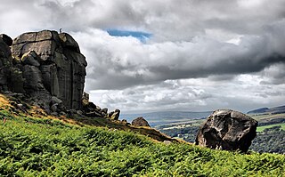
Ilkley Moor is part of Rombalds Moor, the moorland between Ilkley and Keighley in West Yorkshire, England. The moor, which rises to 402 m (1,319 ft) above sea level, is well known as the inspiration for the Yorkshire "county anthem" On Ilkla Moor Baht 'at.

The geology of Great Britain is renowned for its diversity. As a result of its eventful geological history, Great Britain shows a rich variety of landscapes across the constituent countries of England, Wales and Scotland. Rocks of almost all geological ages are represented at outcrop, from the Archaean onwards.

In geology, a rift is a linear zone where the lithosphere is being pulled apart and is an example of extensional tectonics.

Ingleton is a village and civil parish in the Craven district of North Yorkshire, England. The village is 19 miles (30 km) from Kendal and 17 miles (28 km) from Lancaster on the western side of the Pennines. It is 9.3 miles (15 km) from Settle. The River Doe and the River Twiss meet to form the source of the River Greta, a tributary of the River Lune. The village is on the A65 road and at the head of the A687. The B6255 takes the south bank of the River Doe to Ribblehead and Hawes. All that remains of the railway in the village is the landmark Ingleton Viaduct. Arthur Conan Doyle was a regular visitor to the area and was married locally, as his mother lived at Masongill from 1882 to 1917. There is growing evidence to support a claim that the inspiration for the name Sherlock Holmes came from here.

The geology of Scotland is unusually varied for a country of its size, with a large number of differing geological features. There are three main geographical sub-divisions: the Highlands and Islands is a diverse area which lies to the north and west of the Highland Boundary Fault; the Central Lowlands is a rift valley mainly comprising Paleozoic formations; and the Southern Uplands, which lie south of the Southern Uplands Fault, are largely composed of Silurian deposits.
The Zechstein is a unit of sedimentary rock layers of Middle to Late Permian age located in the European Permian Basin which stretches from the east coast of England to northern Poland. The name Zechstein was formerly also used as a unit of time in the geologic timescale, but nowadays it is only used for the corresponding sedimentary deposits in Europe.

Texas contains a great variety of geologic settings. The state's stratigraphy has been largely influenced by marine transgressive-regressive cycles during the Phanerozoic, with a lesser but still significant contribution from late Cenozoic tectonic activity, as well as the remnants of a Paleozoic mountain range.

The New Red Sandstone, chiefly in British geology, is composed of beds of red sandstone and associated rocks laid down throughout the Permian to the end of the Triassic, that underlie the Jurassic-Triassic age Penarth Group. The name distinguishes it from the Old Red Sandstone which is largely Devonian in age, and with which it was originally confused due to their similar composition.
The South Yorkshire Coalfield is so named from its position within Yorkshire. It covers most of South Yorkshire, West Yorkshire and a small part of North Yorkshire. The exposed coalfield outcrops in the Pennine foothills and dips under Permian rocks in the east. Its most famous coal seam is the Barnsley Bed. Coal has been mined from shallow seams and outcrops since medieval times and possibly earlier.
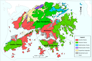
The geology of Hong Kong is dominated by igneous rocks formed during a major volcanic eruption period in the Mesozoic era. It made up 85% of Hong Kong's land surface and the remaining 15% are mostly sedimentary rocks located in the northeast New Territories. There are also a very small percentage of metamorphic rocks in New Territories. These are formed by deformation of pre-existing sedimentary rocks which changed its mineral assemblages (metamorphism).

The Geology of Yorkshire in northern England shows a very close relationship between the major topographical areas and the geological period in which their rocks were formed. The rocks of the Pennine chain of hills in the west are of Carboniferous origin whilst those of the central vale are Permo-Triassic. The North York Moors in the north-east of the county are Jurassic in age while the Yorkshire Wolds to the south east are Cretaceous chalk uplands. The plain of Holderness and the Humberhead levels both owe their present form to the Quaternary ice ages. The strata become gradually younger from west to east.
The Cheshire Basin is a late Palaeozoic and Mesozoic sedimentary basin extending under most of the county of Cheshire in northwest England. It extends northwards into the Manchester area and south into Shropshire. The basin possesses something of the character of a half-graben as its deepest extent is along its eastern and southeastern margins, where it is well defined by a series of sub-parallel faults, most important of which is the Red Rock Fault. These faults divide the basin from the older Carboniferous rocks of the Peak District and the North Staffordshire Coalfield.

The geology of Russia, the world's largest country, which extends over much of northern Eurasia, consists of several stable cratons and sedimentary platforms bounded by orogenic (mountain) belts.

The coal measures is a lithostratigraphical term for the coal-bearing part of the Upper Carboniferous System. The Coal Measures Group consists of the Upper Coal Measures Formation, the Middle Coal Measures Formation and the Lower Coal Measures Formation. The group records the deposition of fluvio-deltaic sediments which consists mainly of clastic rocks interstratified with the beds of coal. In most places, the coal measures are underlain by coarser clastic sequences known as Millstone Grit, of Namurian age. The top of the coal measures may be marked by an unconformity, the overlying rocks being Permian or later in age. In some parts of Britain, however, the Coal Measures grade up into mainly coal-barren red beds of late Westphalian and possibly Stephanian age. Within the Pennine Basin these barren measures are now referred to as the Warwickshire Group, from the district where they achieve their thickest development.

Isis Temple, in the Grand Canyon, Arizona, USA is a prominence below the North Rim, and adjacent Granite Gorge. The prominence lies north of the north bank of the west-flowing Colorado River, and is just north of Middle Granite Gorge. The Trinity Creek and canyon flow due-south at its west border; its north, and northeast border/flank is formed by Phantom Creek and canyon, a west tributary of Bright Angel Creek; the creeks intersect about 3 mi southeast, and 1 mi north of Granite Gorge.
The geology of Lancashire in northwest England consists in the main of Carboniferous age rocks but with Triassic sandstones and mudstones at or near the surface of the lowlands bordering the Irish Sea though these are largely obscured by Quaternary deposits.
The geology of Merseyside in northwest England largely consists of a faulted sequence of Carboniferous Coal Measures rocks overlain in the west by younger Triassic and Permian age sandstones and mudstones. Glaciation during the present Quaternary Period has left widespread glacial till as well as erosional landforms. Other post-glacial superficial deposits such as river and estuarine alluvium, peat and blown sand are abundant.
The geology of County Durham in northeast England consists of a basement of Lower Palaeozoic rocks overlain by a varying thickness of Carboniferous and Permo-Triassic sedimentary rocks which dip generally eastwards towards the North Sea. These have been intruded by a pluton, sills and dykes at various times from the Devonian Period to the Palaeogene. The whole is overlain by a suite of unconsolidated deposits of Quaternary age arising from glaciation and from other processes operating during the post-glacial period to the present. The geological interest of the west of the county was recognised by the designation in 2003 of the North Pennines Area of Outstanding Natural Beauty as a European Geopark.
The Worcester Basin or Worcester Graben is a sedimentary basin in central England, filled with mainly Permian and Triassic rocks. It trends roughly north-south and lies between the East Malverns Fault in the west and the Inkberrow Fault in the east. It forms part of a series of Permo-Triassic basins that stretch north-south across England, including the Cheshire Basin and the East Irish Sea Basin. These basins resulted from a regional rifting event that affected parts of North-West Europe, eastern North America and East Greenland.
The geology of Northumberland in northeast England includes a mix of sedimentary, intrusive and extrusive igneous rocks from the Palaeozoic and Cenozoic eras. Devonian age volcanic rocks and a granite pluton form the Cheviot massif. The geology of the rest of the county is characterised largely by a thick sequence of sedimentary rocks of Carboniferous age. These are intruded by both Permian and Palaeogene dykes and sills and the whole is overlain by unconsolidated sediments from the last ice age and the post-glacial period. The Whin Sill makes a significant impact on Northumberland's character and the former working of the Northumberland Coalfield significantly influenced the development of the county's economy. The county's geology contributes to a series of significant landscape features around which the Northumberland National Park was designated.

