External links
- Zimmerman, Elwood C. (1958). Insects of Hawaii. 7 Macrolepidoptera. University of Hawaii Press, Honolulu. hdl:10125/7336.
| This Noctuinae-related article is a stub. You can help Wikipedia by expanding it. |
| Peridroma coniotis | |
|---|---|
| Scientific classification | |
| Kingdom: | |
| Phylum: | |
| Class: | |
| Order: | |
| Family: | |
| Genus: | |
| Species: | P. coniotis |
| Binomial name | |
| Peridroma coniotis (Hampson, 1903) | |
| Synonyms | |
| |
Peridroma coniotis is a moth of the family Noctuidae. It was first described by George Hampson in 1903. It is endemic to the Hawaiian islands of Kauai and Hawaii.
The larvae feed on Chenopodium species.
| This Noctuinae-related article is a stub. You can help Wikipedia by expanding it. |

Niʻihau anglicized as Niihau is the westernmost main and seventh largest inhabited island in Hawaii. It is 17.5 miles (28.2 km) southwest of Kauaʻi across the Kaulakahi Channel. Its area is 69.5 square miles (180 km2). Several intermittent playa lakes provide wetland habitats for the Hawaiian coot, the Hawaiian stilt, and the Hawaiian duck. The island is designated as critical habitat for Brighamia insignis, an endemic and endangered species of Hawaiian lobelioid. The United States Census Bureau defines Niʻihau and the neighboring island and State Seabird Sanctuary of Lehua as Census Tract 410 of Kauai County, Hawaii. Its 2000 census population was 160; Its 2010 census population was 170.
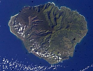
Kauaʻi, anglicized as Kauai, is geologically the second-oldest of the main Hawaiian Islands. With an area of 562.3 square miles (1,456.4 km2), it is the fourth-largest of these islands and the 21st largest island in the United States. Known also as the "Garden Isle", Kauaʻi lies 105 miles (169 km) across the Kauaʻi Channel, northwest of Oʻahu. This island is the site of Waimea Canyon State Park.

Kauaʻi County is a county in the U.S. state of Hawaiʻi. It consists of the islands of Kauaʻi, Niʻihau, Lehua, and Kaʻula. As of the 2010 Census the population was 67,091. The county seat is Līhuʻe.

Menehune are a mythological dwarf people in Hawaiian tradition who are said to live in the deep forests and hidden valleys of the Hawaiian Islands, hidden and far away from human settlements.

Lihue or Līhuʻe is an unincorporated community, census-designated place (CDP) and the county seat of Kauai County, Hawaii, United States. Lihue is the second largest town on the Hawaiian island of Kauaʻi after Kapaʻa. As of the 2010 census, the CDP had a population of 6,455, up from 5,694 at the 2000 census.

Kaumualiʻi was the last independent aliʻi nui of Kauaʻi and Niʻihau before becoming a vassal of Kamehameha I within the unified Kingdom of Hawaiʻi in 1810. He was the 23rd high chief of Kauaʻi and reigned from 1794–1810.

Waimea Canyon, also known as the Grand Canyon of the Pacific, is a large canyon, approximately ten miles (16 km) long and up to 3,000 feet deep, located on the western side of Kauaʻi in the Hawaiian Islands of the United States. Waimea is Hawaiian for "reddish water", a reference to the erosion of the canyon's red soil. The canyon was formed by a deep incision of the Waimea River arising from the extreme rainfall on the island's central peak, Mount Waiʻaleʻale, among the wettest places on earth.

Kauaʻi Community College is a public community college in Līhuʻe, Hawaiʻi and it is the only institution of higher learning on the island. It is part of the University of Hawaiʻi system and is accredited by the Western Association of Schools and Colleges.

Hurricane Iniki was the most powerful hurricane to strike the U.S. state of Hawaii in recorded history. Forming on September 5, 1992, during the strong 1990–1995 El Niño, Iniki was one of eleven Central Pacific tropical cyclones during that season. It attained tropical storm status on September 8 and further intensified into a hurricane the next day. After turning north, Iniki struck the island of Kauaʻi on September 11 at peak intensity; it had winds of 145 mph and reached Category 4 status on the Saffir–Simpson hurricane scale. It had recorded wind gusts of 225 as evidenced by an anemometer that was found blown into the forest during clean up. It was the first hurricane to hit the state since Hurricane Iwa in the 1982 season, and the first major hurricane since Hurricane Dot in 1959. Iniki dissipated on September 13 about halfway between Hawaii and Alaska.

Hurricane Iwa, taken from the Hawaiian language name for the frigatebird, was at the time the costliest hurricane to affect the state of Hawaiʻi. Iwa was the twenty-third tropical storm and the twelfth and final hurricane of the 1982 Pacific hurricane season. It developed from an active trough of low pressure near the equator on November 19. The storm moved erratically northward until becoming a hurricane on November 23 when it began accelerating to the northeast in response to strong upper-level flow from the north. Iwa passed within 25 miles of the island of Kauaʻi with peak winds of 90 mph (145 km/h) on November 23, and the next day it became extratropical to the northeast of the state.
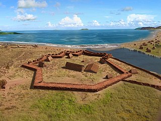
Russian Fort Elizabeth is a National Historic Landmark and is administered as the Russian Fort Elizabeth State Historical Park just southeast of present-day Waimea on the island of Kauaʻi in Hawaiʻi. It is located at the site of the former Fort Elizavety, the last remaining Russian fort on the Hawaiian islands, built in the early 19th century by the Russian-American Company as the result of an alliance with High Chief Kaumualiʻi. The star fort was employed by the Kingdom of Hawaii in the 19th century under the name Fort Hipo.
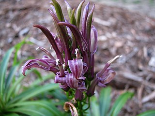
The Hawaiian lobelioids are a group of flowering plants in the bellflower family, Campanulaceae, all of which are endemic to the Hawaiian Islands. This is the largest plant radiation in the Hawaiian Islands, and indeed the largest on any island archipelago, with over 125 species. The six genera can be broadly separated based on growth habit: Clermontia are typically branched shrubs or small trees, up to 7 metres (23 ft) tall, with fleshy fruits; Cyanea and Delissea are typically unbranched or branching only at the base, with a cluster of relatively broad leaves at the apex and fleshy fruits; Lobelia and Trematolobelia have long thin leaves down a single, non-woody stem and capsular fruits with wind-dispersed seeds; and the peculiar Brighamia have a short, thick stem with a dense cluster of broad leaves, elongate white flowers, and capsular fruits.

The energy sector in Hawaii has rapidly adopted solar power due to the high costs of electricity, and good solar resources, and has one of the highest per capita rates of solar power in the United States. Hawaii's imported energy costs, mostly for imported petroleum and coal, are three to four times higher than the mainland, so Hawaii has motivation to become one of the highest users of solar energy. Hawaii was the first state in the United States to reach grid parity for photovoltaics. Its tropical location provides abundant ambient energy.

The Makauwahi Cave is the largest limestone cave found in Hawaii. It lies on the south coast of the island of Kauaʻi, in the Māhāʻulepū Valley close to Māhāʻulepū Beach, and is important for its paleoecological and archaeological values. It is reached via a sinkhole and has been described as “…maybe the richest fossil site in the Hawaiian Islands, perhaps in the entire Pacific Island region”.
Peridroma cinctipennis is a moth of the family Noctuidae. It was first described by Arthur Gardiner Butler in 1881. It is endemic to the Hawaiian islands of Kauai, Oahu, Molokai, Maui and Hawaii.
Peridroma selenias is a moth of the family Noctuidae. It was first described by Edward Meyrick in 1899. It is endemic to the Hawaiian islands of Kauai, Oahu and Hawaii.

Kawaikini is the highest point on the Hawaiian Island of Kauai and in Kauai County and measures 5,243 feet (1,598 m) in elevation. It is the summit of the island's inactive central shield volcano, Mount Waialeale. Other peaks on Kauai include: Waialeale, Namolokama Mountain, Kalalau Lookout, Keanapuka Mountain, Haupu and Nounou.