
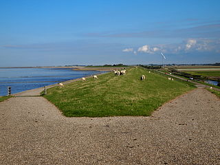
The Western Scheldt, in the province of Zeeland in the southwestern Netherlands, is the estuary of the Scheldt river. This river once had several estuaries, but the others are now disconnected from the Scheldt, leaving the Westerschelde as its only direct route to the sea. The Western Scheldt is an important shipping route to the Port of Antwerp, Belgium. Unlike the Eastern Scheldt estuary, it could not be closed off from the sea by a dam as part of the Delta Works. Instead, the dykes around it have been heightened and reinforced.

Zeelandic Flanders is the southernmost region of the province of Zeeland in the south-western Netherlands. It lies south of the Western Scheldt that separates the region from the remainder of Zeeland and the Netherlands to the north. Zeelandic Flanders is bordered to the south and to the east by Belgium.

Zuid-Beveland is part of the province of Zeeland in the Netherlands north of the Western Scheldt and south of the Eastern Scheldt.
Zuid Haffel is a polder and hamlet in the northwest of the Netherlands. It is located on the island of Texel, North Holland. Texel is also the municipality of the place.

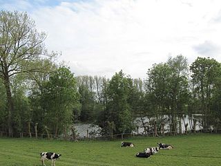
Kruiningen is a village in the Dutch province of Zeeland. It is located in the municipality of Reimerswaal, about 5 km south of the village of Yerseke.

Oud-Kamerik is a hamlet in the Dutch province of Utrecht. It is a part of the municipality of Woerden, and lies about 6 km northwest of the city of Woerden.

Gerverscop is a hamlet in the Dutch province of Utrecht. It is a part of the municipality of Woerden, and lies about 5 km northeast of Woerden. Until 1857, it was a separate municipality; it then was joined to the municipality of Harmelen.
Achthoven is a hamlet in the Dutch province of Utrecht. It is a part of the municipality of Vijfheerenlanden, and lies about 7 km south of IJsselstein.

Kievitswaard is a hamlet in the Dutch province of North Brabant. It is a part of the municipality of Altena, and lies about 10 km east of Dordrecht. Kievitswaard lies in the Biesbosch area.

Berkmeer is a hamlet in the Dutch province of North Holland. It is a part of the municipality of Koggenland, and lies about 5 km east of Heerhugowaard.

Walsoorden is a village in the Dutch province of Zeeland. It is a part of the municipality of Hulst, and lies about 22 km southwest of Bergen op Zoom.

Ossenisse is a village in the Dutch province of Zeeland. It is a part of the municipality of Hulst, and lies about 24 km west of Bergen op Zoom.

Nieuw- en Sint Joosland of Nieuwland is a village and a former municipality in the southeast of Walcheren, at the edge of the island, in the municipality Middelburg, in the Dutch province of Zeeland. It has about 1300 inhabitants. Because of its relatively late foundation, Nieuw- en Sint Joosland is not a churchvillage, but more of a wegdorp, despite its clear village centre.

Waarde is a village in the Dutch province of Zeeland. It is located in the municipality of Reimerswaal, about 4 km southeast of Kruiningen.

Mastenbroek is a polder in the Dutch province of Overijssel. It lies north of the city of Zwolle. "Mastenbroek" is also the name of an hamlet, built around a church in the middle of the polder.
Westhoek is a village in Waadhoeke in the province of Friesland, the Netherlands. It had a population of approximately 255 in 2021.

The Western Scheldt Tunnel is a 6.6-kilometre (4.1 mi) tunnel in the Netherlands that carries highway N62 under the Western Scheldt estuary between Ellewoutsdijk and Terneuzen. It is the longest tunnel for highway traffic in the Netherlands.

Lytse Geast is a hamlet in Tytsjerksteradiel in the province of Friesland, the Netherlands.

Kingmatille is a smock mill in Dronryp, Friesland, Netherlands which was moved to its present location in 1985. The mill is listed as a Rijksmonument, number 28614. The windmill is named after the nearby hamlet of Kingmatille.

Reimerswaal is a municipality in the province of Zeeland in the southwestern Netherlands on Zuid-Beveland, named after the lost city. The municipality had a population of 22,896 in 2021, and has a surface area of 242.42 km2 (93.60 sq mi) of which 140.62 km2 (54.29 sq mi) is water. The central town Yerseke is known for trade in mussels and oysters. Kruiningen is known for the former ferry from Kruiningen to Perkpolder which was in service up to 2003. The municipality of Reimerswaal was established in 1970, from the aggregation of the municipalities Krabbendijke, Kruiningen, Rilland-Bath, Waarde, and Yerseke.


