Paal | |
|---|---|
Hamlet | |
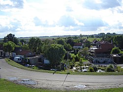 View on Paal | |
 Paal Location in the province of Zeeland in the Netherlands  Paal Paal (Netherlands) | |
| Coordinates: 51°21′16″N04°06′27″E / 51.35444°N 4.10750°E | |
| Country | Netherlands |
| Province | Zeeland |
| Municipality | Hulst |
| Area | |
• Total | 0.12 km2 (0.05 sq mi) |
| Elevation | 0.6 m (2.0 ft) |
| Population (2021) [1] | |
• Total | 75 |
| • Density | 630/km2 (1,600/sq mi) |
| Time zone | UTC+1 (CET) |
| • Summer (DST) | UTC+2 (CEST) |
| Postal code | 4569 [1] |
| Dialing code | 0114 |
Paal is a hamlet in the southwest Netherlands. It is a part of the municipality of Hulst, Zeeland, and is located 35 km north of Antwerp, Belgium.
The village was first mentioned in 1847 as Paal (De), and refers to a beacon. From at least 1676 until 1874 there was a ferry to Bergen op Zoom at the location. [3]
Paal used to be a fishing village which specialised in mussels. It was home to 412 people in 1840. In 1979, the dike was enlarged and the old harbour disappeared. In 1980, a marina was built instead. [4]
Paal used to be part of the municipality of Graauw en Langendam. In 2003, it was merged into Hulst. [4]

